Premium Framed Print > Animals > Mammals > Soricidae > Niger
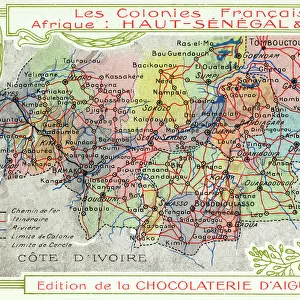
Premium Framed Print : Senegal and Niger, French Colonies in Africa - Map


![]()
Framed Photos from Mary Evans Picture Library
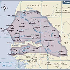
Senegal and Niger, French Colonies in Africa - Map
Senegal and Niger, French Colonies in Africa - Map showing main transport routes. Date: circa 1909
Mary Evans Picture Library makes available wonderful images created for people to enjoy over the centuries
Media ID 11580045
© Mary Evans / Grenville Collins Postcard Collection
Banks Colonies Colony Countries Edition Niger Railways Roads Senegal Senegalese Chocolaterie Daiguebelle
23"x19" (58x48cm) Premium Frame
FSC real wood frame with double mounted 16x12 print. Double mounted with white conservation mountboard. Frame moulding comprises stained composite natural wood veneers (Finger Jointed Pine) 39mm wide by 21mm thick. Archival quality Fujifilm CA photo paper mounted onto 1mm card. Overall outside dimensions are 23x19 inches (584x482mm). Rear features Framing tape to cover staples, 50mm Hanger plate, cork bumpers. Glazed with durable thick 2mm Acrylic to provide a virtually unbreakable glass-like finish. Acrylic Glass is far safer, more flexible and much lighter than typical mineral glass. Moreover, its higher translucency makes it a perfect carrier for photo prints. Acrylic allows a little more light to penetrate the surface than conventional glass and absorbs UV rays so that the image and the picture quality doesn't suffer under direct sunlight even after many years. Easily cleaned with a damp cloth. Please note that, to prevent the paper falling through the mount window and to prevent cropping of the original artwork, the visible print may be slightly smaller to allow the paper to be securely attached to the mount without any white edging showing and to match the aspect ratio of the original artwork.
FSC Real Wood Frame and Double Mounted with White Conservation Mountboard - Professionally Made and Ready to Hang
Estimated Image Size (if not cropped) is 39.6cm x 25.8cm (15.6" x 10.2")
Estimated Product Size is 58.4cm x 48.2cm (23" x 19")
These are individually made so all sizes are approximate
Artwork printed orientated as per the preview above, with landscape (horizontal) orientation to match the source image.
FEATURES IN THESE COLLECTIONS
> Africa
> Niger
> Related Images
> Africa
> Related Images
> Africa
> Senegal
> Related Images
> Animals
> Mammals
> Soricidae
> Niger
> Arts
> Landscape paintings
> Waterfall and river artworks
> River artworks
EDITORS COMMENTS
This vintage map print, circa 1909, showcases the French colonies of Senegal and Niger in Africa. The intricately detailed illustration highlights the geographical features and transport routes that connected these colonies during the colonial era. The map depicts the Senegal River, a major waterway that flows through both Senegal and Mauritania, and serves as a vital source of water and transportation. The riverbanks are marked with European settlements, including the important ports of Saint-Louis and Dakar in Senegal. The railway system, a key component of the colonial infrastructure, is also prominently featured. The Trans-Saharan Railway, which runs through Niger, is shown connecting the port of Dakar in Senegal with the Nigerian capital of Niamey. This railway facilitated the movement of goods and people between the coastal regions and the interior of the continent. Roads, marked as "routes," crisscross the map, connecting various towns and villages within the colonies. The map also indicates several important European trading companies, such as the Chocolaterie Daiguebelle, which had a significant presence in Senegal. This map provides a glimpse into the historical context of the French colonies in Africa during the late 19th and early 20th centuries. It illustrates the extensive transportation networks that were established to facilitate the movement of goods, people, and ideas between the European colonizers and the African populations they governed. The map also serves as a reminder of the complex and intricate history of colonialism in Africa and its lasting impact on the continent.
MADE IN THE UK
Safe Shipping with 30 Day Money Back Guarantee
FREE PERSONALISATION*
We are proud to offer a range of customisation features including Personalised Captions, Color Filters and Picture Zoom Tools
SECURE PAYMENTS
We happily accept a wide range of payment options so you can pay for the things you need in the way that is most convenient for you
* Options may vary by product and licensing agreement. Zoomed Pictures can be adjusted in the Basket.