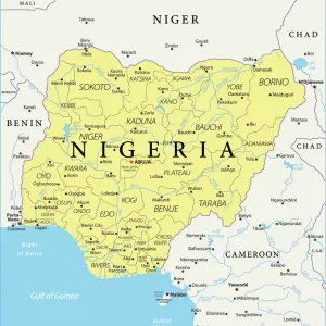
Framed Print > Animals > Mammals > Soricidae > Niger
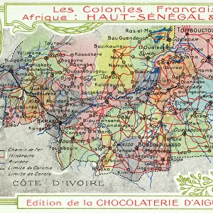
Framed Print : Senegal and Niger, French Colonies in Africa - Map


![]()
Framed Photos from Mary Evans Picture Library
Senegal and Niger, French Colonies in Africa - Map
Senegal and Niger, French Colonies in Africa - Map showing main transport routes. Date: circa 1909
Mary Evans Picture Library makes available wonderful images created for people to enjoy over the centuries
Media ID 11580045
© Mary Evans / Grenville Collins Postcard Collection
Banks Colonies Colony Countries Edition Niger Railways Roads Senegal Senegalese Chocolaterie Daiguebelle
22"x18" (58x48cm) Modern Frame
Introducing the stunning "Senegal and Niger, French Colonies in Africa - Map" print from our Media Storehouse Framed Prints collection. This captivating piece, sourced from Mary Evans Prints Online, takes you on a journey back in time to circa 1909. The map showcases the French colonies of Senegal and Niger in Africa, with intricate detail and precision. The design highlights the main transport routes, providing a fascinating insight into the historical connections between these territories. Our Framed Prints are meticulously crafted with museum-quality materials to ensure your new addition to your home or office is not only a beautiful conversation starter but also a long-lasting investment. Embrace the rich history of Africa and bring a piece of the past into your space with this exquisite framed map print.
Wood effect frame, card mounted, 16x12 archival quality photo print. Overall outside dimensions 22x18 inches (58x48cm). Environmentally and ozone friendly, 40mm wide x 15mm Polycore® moulding has the look of real wood, is durable and light and easy to hang. Biodegradable and made with non-chlorinated gases (no toxic fumes) it is efficient; producing 100 tons of polystyrene can save 300 tons of trees! Prints are glazed with lightweight, shatterproof, optical clarity acrylic (providing the same general protection from the environment as glass). The back is stapled hardboard with a sawtooth hanger attached. Note: To minimise original artwork cropping, for optimum layout, and to ensure print is secure, the visible print may be marginally smaller
Contemporary Framed and Mounted Prints - Professionally Made and Ready to Hang
Estimated Image Size (if not cropped) is 39.6cm x 25.8cm (15.6" x 10.2")
Estimated Product Size is 57.9cm x 47.8cm (22.8" x 18.8")
These are individually made so all sizes are approximate
Artwork printed orientated as per the preview above, with landscape (horizontal) orientation to match the source image.
FEATURES IN THESE COLLECTIONS
> Africa
> Niger
> Related Images
> Africa
> Related Images
> Africa
> Senegal
> Related Images
> Animals
> Mammals
> Soricidae
> Niger
> Arts
> Landscape paintings
> Waterfall and river artworks
> River artworks
EDITORS COMMENTS
This vintage map print, circa 1909, showcases the French colonies of Senegal and Niger in Africa. The intricately detailed illustration highlights the geographical features and transport routes that connected these colonies during the colonial era. The map depicts the Senegal River, a major waterway that flows through both Senegal and Mauritania, and serves as a vital source of water and transportation. The riverbanks are marked with European settlements, including the important ports of Saint-Louis and Dakar in Senegal. The railway system, a key component of the colonial infrastructure, is also prominently featured. The Trans-Saharan Railway, which runs through Niger, is shown connecting the port of Dakar in Senegal with the Nigerian capital of Niamey. This railway facilitated the movement of goods and people between the coastal regions and the interior of the continent. Roads, marked as "routes," crisscross the map, connecting various towns and villages within the colonies. The map also indicates several important European trading companies, such as the Chocolaterie Daiguebelle, which had a significant presence in Senegal. This map provides a glimpse into the historical context of the French colonies in Africa during the late 19th and early 20th centuries. It illustrates the extensive transportation networks that were established to facilitate the movement of goods, people, and ideas between the European colonizers and the African populations they governed. The map also serves as a reminder of the complex and intricate history of colonialism in Africa and its lasting impact on the continent.
MADE IN THE UK
Safe Shipping with 30 Day Money Back Guarantee
FREE PERSONALISATION*
We are proud to offer a range of customisation features including Personalised Captions, Color Filters and Picture Zoom Tools
SECURE PAYMENTS
We happily accept a wide range of payment options so you can pay for the things you need in the way that is most convenient for you
* Options may vary by product and licensing agreement. Zoomed Pictures can be adjusted in the Basket.