Premium Framed Print > Europe > France > Canton > Landes
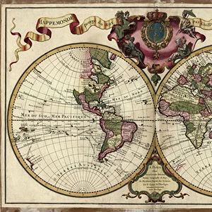
Premium Framed Print : 1852, Levasseur Map of Asia, topography, cartography, geography, land, illustration


![]()
Framed Photos from Liszt Collection
1852, Levasseur Map of Asia, topography, cartography, geography, land, illustration
1852, Levasseur Map of Asia
Liszt Collection of nineteenth-century engravings and images to browse and enjoy
Media ID 14007369
© Artokoloro Quint Lox Limited
1852 Antique Map Latitude Longitude Mappa Mundi Old Antique Plan Old Antique View Ols Antique Map Rare Old Maps Topo
17"x15" (43x38cm) Premium Frame
FSC real wood frame with double mounted 10x8 print. Double mounted with white conservation mountboard. Frame moulding comprises stained composite natural wood veneers (Finger Jointed Pine) 39mm wide by 21mm thick. Archival quality Fujifilm CA photo paper mounted onto 1mm card. Overall outside dimensions are 17x15 inches (431x381mm). Rear features Framing tape to cover staples, 50mm Hanger plate, cork bumpers. Glazed with durable thick 2mm Acrylic to provide a virtually unbreakable glass-like finish. Acrylic Glass is far safer, more flexible and much lighter than typical mineral glass. Moreover, its higher translucency makes it a perfect carrier for photo prints. Acrylic allows a little more light to penetrate the surface than conventional glass and absorbs UV rays so that the image and the picture quality doesn't suffer under direct sunlight even after many years. Easily cleaned with a damp cloth. Please note that, to prevent the paper falling through the mount window and to prevent cropping of the original artwork, the visible print may be slightly smaller to allow the paper to be securely attached to the mount without any white edging showing and to match the aspect ratio of the original artwork.
FSC Real Wood Frame and Double Mounted with White Conservation Mountboard - Professionally Made and Ready to Hang
Estimated Image Size (if not cropped) is 24.4cm x 17cm (9.6" x 6.7")
Estimated Product Size is 43.1cm x 38.1cm (17" x 15")
These are individually made so all sizes are approximate
Artwork printed orientated as per the preview above, with landscape (horizontal) orientation to match the source image.
FEATURES IN THESE COLLECTIONS
> Europe
> France
> Canton
> Landes
> Historic
> Space exploration
> Maps and Charts
> Early Maps
> Maps and Charts
> Related Images
> Maps and Charts
> World
EDITORS COMMENTS
This print showcases the exquisite "1852, Levasseur Map of Asia" a true masterpiece in the realms of topography, cartography, and geography. With its intricate details and stunning illustration, this vintage map takes us on a journey through time to explore the vast lands and diverse regions of Asia. The carefully plotted grid lines reveal latitude and longitude coordinates, allowing for precise navigation across this ancient world. Every contour and feature is meticulously depicted, offering an invaluable resource for historians and explorers alike. Its aged appearance adds a touch of historical charm that transports us back to an era when maps were cherished works of art. As we gaze upon this rare old map from the Liszt Collection, we cannot help but marvel at the level of craftsmanship involved in its creation. The paper's texture further enhances its authenticity while evoking a sense of nostalgia for bygone days. This remarkable piece invites us to embark on a visual exploration where history meets geography. It serves as a reminder that our planet's past holds countless stories waiting to be discovered. Whether you are an avid traveler or simply appreciate fine art with historical significance, this Levasseur Map will undoubtedly captivate your imagination and transport you into the heart of Asia's rich cultural heritage.
MADE IN THE UK
Safe Shipping with 30 Day Money Back Guarantee
FREE PERSONALISATION*
We are proud to offer a range of customisation features including Personalised Captions, Color Filters and Picture Zoom Tools
SECURE PAYMENTS
We happily accept a wide range of payment options so you can pay for the things you need in the way that is most convenient for you
* Options may vary by product and licensing agreement. Zoomed Pictures can be adjusted in the Basket.