Framed Print > Europe > France > Canton > Landes
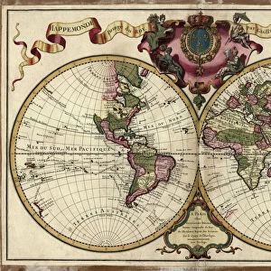
Framed Print : 1852, Levasseur Map of Asia, topography, cartography, geography, land, illustration


![]()
Framed Photos from Liszt Collection
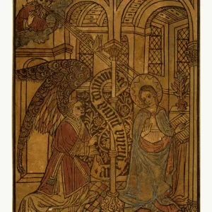
1852, Levasseur Map of Asia, topography, cartography, geography, land, illustration
1852, Levasseur Map of Asia
Liszt Collection of nineteenth-century engravings and images to browse and enjoy
Media ID 14007369
© Artokoloro Quint Lox Limited
1852 Antique Map Latitude Longitude Mappa Mundi Old Antique Plan Old Antique View Ols Antique Map Rare Old Maps Topo
14"x12" (38x32cm) Modern Frame
Discover the rich history of cartography with our stunning Framed Print from the Media Storehouse collection. This exquisite piece features the 1852 Levasseur Map of Asia, an essential work of topography, cartography, and geography from the esteemed Liszt Collection. Delve into the intricacies of Asian landmasses as depicted in this beautiful illustration, a testament to the meticulous detail and artistic craftsmanship of the time. Elevate your home or office decor with this captivating and educational framed print, a conversation starter that combines history and artistry in perfect harmony.
Wood effect frame, card mounted, 10x8 archival quality photo print. Overall outside dimensions 14x12 inches (38x32cm). Environmentally and ozone friendly, 40mm wide x 15mm Polycore® moulding has the look of real wood, is durable and light and easy to hang. Biodegradable and made with non-chlorinated gases (no toxic fumes) it is efficient; producing 100 tons of polystyrene can save 300 tons of trees! Prints are glazed with lightweight, shatterproof, optical clarity acrylic (providing the same general protection from the environment as glass). The back is stapled hardboard with a sawtooth hanger attached. Note: To minimise original artwork cropping, for optimum layout, and to ensure print is secure, the visible print may be marginally smaller
Contemporary Framed and Mounted Prints - Professionally Made and Ready to Hang
Estimated Image Size (if not cropped) is 24.4cm x 17cm (9.6" x 6.7")
Estimated Product Size is 37.6cm x 32.5cm (14.8" x 12.8")
These are individually made so all sizes are approximate
Artwork printed orientated as per the preview above, with landscape (horizontal) orientation to match the source image.
FEATURES IN THESE COLLECTIONS
> Europe
> France
> Canton
> Landes
> Historic
> Space exploration
> Maps and Charts
> Early Maps
> Maps and Charts
> Related Images
> Maps and Charts
> World
EDITORS COMMENTS
This print showcases the exquisite "1852, Levasseur Map of Asia" a true masterpiece in the realms of topography, cartography, and geography. With its intricate details and stunning illustration, this vintage map takes us on a journey through time to explore the vast lands and diverse regions of Asia. The carefully plotted grid lines reveal latitude and longitude coordinates, allowing for precise navigation across this ancient world. Every contour and feature is meticulously depicted, offering an invaluable resource for historians and explorers alike. Its aged appearance adds a touch of historical charm that transports us back to an era when maps were cherished works of art. As we gaze upon this rare old map from the Liszt Collection, we cannot help but marvel at the level of craftsmanship involved in its creation. The paper's texture further enhances its authenticity while evoking a sense of nostalgia for bygone days. This remarkable piece invites us to embark on a visual exploration where history meets geography. It serves as a reminder that our planet's past holds countless stories waiting to be discovered. Whether you are an avid traveler or simply appreciate fine art with historical significance, this Levasseur Map will undoubtedly captivate your imagination and transport you into the heart of Asia's rich cultural heritage.
MADE IN THE UK
Safe Shipping with 30 Day Money Back Guarantee
FREE PERSONALISATION*
We are proud to offer a range of customisation features including Personalised Captions, Color Filters and Picture Zoom Tools
SECURE PAYMENTS
We happily accept a wide range of payment options so you can pay for the things you need in the way that is most convenient for you
* Options may vary by product and licensing agreement. Zoomed Pictures can be adjusted in the Basket.