Premium Framed Print > Animals > Mammals > Cats (Domestic) > Somali
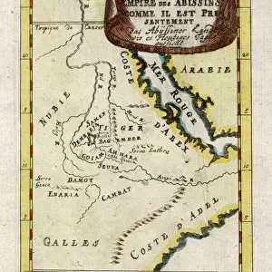
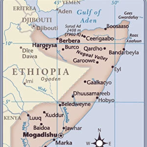
Premium Framed Print : De Djibouti a Addis-Abeba; Le Nord-Est Africain, 1914. Creator: Unknown


![]()
Framed Photos from Heritage Images
De Djibouti a Addis-Abeba; Le Nord-Est Africain, 1914. Creator: Unknown
De Djibouti a Addis-Abeba; Le Nord-Est Africain, 1914. From "Grande Geographie Bong Illustree", 1914
Heritage Images features heritage image collections
Media ID 36296321
© The Print Collector/Heritage Images
Abyssinia Abyssinian Cartography Ethiopia Map Making Mapmaking Somalia
17"x15" (43x38cm) Premium Frame
FSC real wood frame with double mounted 10x8 print. Double mounted with white conservation mountboard. Frame moulding comprises stained composite natural wood veneers (Finger Jointed Pine) 39mm wide by 21mm thick. Archival quality Fujifilm CA photo paper mounted onto 1mm card. Overall outside dimensions are 17x15 inches (431x381mm). Rear features Framing tape to cover staples, 50mm Hanger plate, cork bumpers. Glazed with durable thick 2mm Acrylic to provide a virtually unbreakable glass-like finish. Acrylic Glass is far safer, more flexible and much lighter than typical mineral glass. Moreover, its higher translucency makes it a perfect carrier for photo prints. Acrylic allows a little more light to penetrate the surface than conventional glass and absorbs UV rays so that the image and the picture quality doesn't suffer under direct sunlight even after many years. Easily cleaned with a damp cloth. Please note that, to prevent the paper falling through the mount window and to prevent cropping of the original artwork, the visible print may be slightly smaller to allow the paper to be securely attached to the mount without any white edging showing and to match the aspect ratio of the original artwork.
FSC Real Wood Frame and Double Mounted with White Conservation Mountboard - Professionally Made and Ready to Hang
Estimated Image Size (if not cropped) is 24.4cm x 17.6cm (9.6" x 6.9")
Estimated Product Size is 43.1cm x 38.1cm (17" x 15")
These are individually made so all sizes are approximate
Artwork printed orientated as per the preview above, with landscape (horizontal) orientation to match the source image.
FEATURES IN THESE COLLECTIONS
> Africa
> Djibouti
> Related Images
> Africa
> Ethiopia (Abyssinia)
> Maps
> Africa
> Ethiopia (Abyssinia)
> Related Images
> Africa
> Ethiopia
> Related Images
> Africa
> Somalia
> Related Images
> Animals
> Mammals
> Cats (Domestic)
> Somali
> Europe
> France
> Canton
> Nord
De Djibouti a Addis-Abeba; Le Nord-Est Africain,
EDITORS COMMENTS
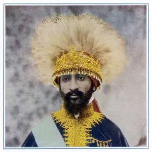
translated to "From Djibouti to Addis-Abeba: The Northeastern Africa," is an intriguing and historically significant map print from the early 20th century. The map, created in 1914, is a fascinating representation of the geographical knowledge of the time, with a focus on the northeastern region of Africa, encompassing present-day Ethiopia, Eritrea, Djibouti, and Somalia. The map's creator remains unknown, but it was published in the renowned French geographical journal "Grande Geographie Illustree," adding to its credibility and historical value. The map's vibrant colors and detailed cartography reflect the meticulous work of the mapmaker, showcasing the diverse topography, political boundaries, and major cities of the region. At the turn of the 20th century, Europe's colonial powers were actively expanding their influence in Africa, and this map reflects the geopolitical landscape of the time. The French presence is evident, with French Somaliland and French Equatorial Africa labeled on the map. The map also highlights the Abyssinian Empire, which was under the rule of Emperor Haile Selassie I, and the Italian colony of Eritrea. The map serves as a testament to the advancements in mapmaking during the 1900s and the European exploration and colonization of Africa. It offers a glimpse into the geographical knowledge of the time and the political realities of the region, making it an essential addition to any collection of historical maps or African studies. Despite its age, the map's intricate details and vivid colors continue to captivate and inform, making it a valuable historical artifact.
MADE IN THE UK
Safe Shipping with 30 Day Money Back Guarantee
FREE PERSONALISATION*
We are proud to offer a range of customisation features including Personalised Captions, Color Filters and Picture Zoom Tools
SECURE PAYMENTS
We happily accept a wide range of payment options so you can pay for the things you need in the way that is most convenient for you
* Options may vary by product and licensing agreement. Zoomed Pictures can be adjusted in the Basket.