Premium Framed Print > Africa > Algeria > Maps
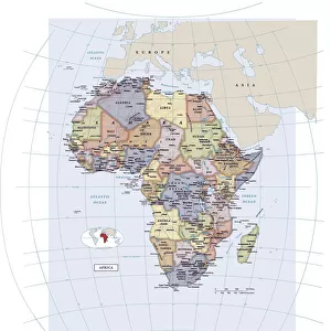
Premium Framed Print : Political Map of Africa


![]()
Framed Photos from Fine Art Storehouse
Political Map of Africa
Vector Illustration of the policital map of Africa
Reference map as created by the US Central Intelligence Agency
Unleash your creativity and transform your space into a visual masterpiece!
calvindexter
Media ID 20251035
Adventure Algeria Backgrounds Business Concepts Creativity Data Design Element Division Exploration Global Communications Government Icon Ideas Indian Ocean Infographic International Border Island Journey Kenya Land Libya Madagascar Newspaper Outline Politics Sign Silhouette South Africa Sudan Symbol Technology Topography Trip Unity Vector World Map Mauritania Nigeria Political Map Social Media South Atlantic Ocean
31"x27" (79x69cm) Premium Frame
FSC real wood frame with double mounted 24x20 print. Double mounted with white conservation mountboard. Frame moulding comprises stained composite natural wood veneers (Finger Jointed Pine) 39mm wide by 21mm thick. Archival quality Fujifilm CA photo paper mounted onto 1mm card. Overall outside dimensions are 31x27 inches (787x685mm). Rear features Framing tape to cover staples, 50mm Hanger plate, cork bumpers. Glazed with durable thick 2mm Acrylic to provide a virtually unbreakable glass-like finish. Acrylic Glass is far safer, more flexible and much lighter than typical mineral glass. Moreover, its higher translucency makes it a perfect carrier for photo prints. Acrylic allows a little more light to penetrate the surface than conventional glass and absorbs UV rays so that the image and the picture quality doesn't suffer under direct sunlight even after many years. Easily cleaned with a damp cloth. Please note that, to prevent the paper falling through the mount window and to prevent cropping of the original artwork, the visible print may be slightly smaller to allow the paper to be securely attached to the mount without any white edging showing and to match the aspect ratio of the original artwork.
FSC Real Wood Frame and Double Mounted with White Conservation Mountboard - Professionally Made and Ready to Hang
Estimated Image Size (if not cropped) is 59.9cm x 59.9cm (23.6" x 23.6")
Estimated Product Size is 68.5cm x 78.7cm (27" x 31")
These are individually made so all sizes are approximate
Artwork printed orientated as per the preview above, with landscape (horizontal) or portrait (vertical) orientation to match the source image.
FEATURES IN THESE COLLECTIONS
> Fine Art Storehouse
> Map
> Reference Maps
> Fine Art Storehouse
> Top Sellers - Art Prints
> Africa
> Algeria
> Related Images
> Africa
> Kenya
> Related Images
> Africa
> Libya
> Related Images
> Africa
> Madagascar
> Maps
> Africa
> Madagascar
> Related Images
> Africa
> Mauritania
> Maps
> Africa
> Mauritania
> Related Images
> Maps and Charts
> Popular Maps
EDITORS COMMENTS
This print showcases the intricate and detailed "Political Map of Africa". Created by the US Central Intelligence Agency, this vector illustration is a true masterpiece of cartography. The map encompasses the vast African continent, highlighting its diverse countries and their political boundaries. With its vibrant colors and precise design elements, this artwork sparks creativity and ignites a sense of exploration. It invites viewers on a journey to discover Africa's rich cultural heritage, breathtaking coastlines, and enchanting islands. Whether you are an adventurer or simply fascinated by world maps, this print will transport you to new horizons. Beyond its aesthetic appeal, this map symbolizes more than just geography; it represents government systems, politics, unity, division, global communications, and international borders. It serves as a powerful reminder of our interconnectedness in today's fast-paced world. Perfect for any business or technology setting seeking inspiration or adding visual interest to their space - be it an office backdrop or social media content - this print seamlessly combines artistry with informative data. Its topographical features beautifully depict Africa's physical geography while conveying essential information about each country. From Algeria to South Africa and from Libya to Madagascar – every nation is meticulously outlined within the silhouette of the continent itself. This stunning piece captures both the beauty and complexity that define Africa while offering endless possibilities for interpretation and appreciation.
MADE IN THE UK
Safe Shipping with 30 Day Money Back Guarantee
FREE PERSONALISATION*
We are proud to offer a range of customisation features including Personalised Captions, Color Filters and Picture Zoom Tools
SECURE PAYMENTS
We happily accept a wide range of payment options so you can pay for the things you need in the way that is most convenient for you
* Options may vary by product and licensing agreement. Zoomed Pictures can be adjusted in the Basket.