Premium Framed Print > Europe > Italy > Lazio > Rome
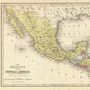
Premium Framed Print : Geography map: representation of the Yucatan ratings in southern Mexico and the Honduras coasts, made by Dutch cartographer Gerard van Keulen (1678-1726) 1709-1713. Biblioteca Angelica, Rome
 1709-1713. Biblioteca Angelica, Rome")
 1709-1713. Biblioteca Angelica, Rome")


![]()
Framed Photos from Fine Art Finder
Geography map: representation of the Yucatan ratings in southern Mexico and the Honduras coasts, made by Dutch cartographer Gerard van Keulen (1678-1726) 1709-1713. Biblioteca Angelica, Rome
VEN5030127 Geography map: representation of the Yucatan ratings in southern Mexico and the Honduras coasts, made by Dutch cartographer Gerard van Keulen (1678-1726) 1709-1713. Biblioteca Angelica, Rome; (add.info.: Geography map: representation of the Yucatan ratings in southern Mexico and the Honduras coasts, made by Dutch cartographer Gerard van Keulen (1678-1726) 1709-1713. Biblioteca Angelica, Rome); © Marage Photos
Media ID 38167632
© © Marage Photos / Bridgeman Images
Amerique Centrale Amerique Du Nord Carte Geographique Central America Etats Unis Geographie Honduras Mexicans Mexico Mexican Mexique Stockravenna 18eme Siecle Geographical Map
23"x19" (58x48cm) Premium Frame
FSC real wood frame with double mounted 16x12 print. Double mounted with white conservation mountboard. Frame moulding comprises stained composite natural wood veneers (Finger Jointed Pine) 39mm wide by 21mm thick. Archival quality Fujifilm CA photo paper mounted onto 1mm card. Overall outside dimensions are 23x19 inches (584x482mm). Rear features Framing tape to cover staples, 50mm Hanger plate, cork bumpers. Glazed with durable thick 2mm Acrylic to provide a virtually unbreakable glass-like finish. Acrylic Glass is far safer, more flexible and much lighter than typical mineral glass. Moreover, its higher translucency makes it a perfect carrier for photo prints. Acrylic allows a little more light to penetrate the surface than conventional glass and absorbs UV rays so that the image and the picture quality doesn't suffer under direct sunlight even after many years. Easily cleaned with a damp cloth. Please note that, to prevent the paper falling through the mount window and to prevent cropping of the original artwork, the visible print may be slightly smaller to allow the paper to be securely attached to the mount without any white edging showing and to match the aspect ratio of the original artwork.
FSC Real Wood Frame and Double Mounted with White Conservation Mountboard - Professionally Made and Ready to Hang
Estimated Image Size (if not cropped) is 39.6cm x 26.4cm (15.6" x 10.4")
Estimated Product Size is 58.4cm x 48.2cm (23" x 19")
These are individually made so all sizes are approximate
Artwork printed orientated as per the preview above, with landscape (horizontal) orientation to match the source image.
FEATURES IN THESE COLLECTIONS
> Fine Art Finder
> Artists
> Unknown Artist
> Europe
> Italy
> Lazio
> Rome
> Maps and Charts
> Early Maps
> Maps and Charts
> Related Images
> North America
> Honduras
> Maps
> North America
> Honduras
> Related Images
> North America
> Mexico
> Maps
> North America
> Mexico
> Related Images
> North America
> United States of America
> Maps
EDITORS COMMENTS
This stunning print showcases a geography map created by Dutch cartographer Gerard van Keulen between 1709-1713, depicting the Yucatan peninsula in southern Mexico and the coasts of Honduras. The intricate details and accuracy of this map are a testament to Van Keulen's skill and expertise in cartography during the early 18th century.
The map, housed in the Biblioteca Angelica in Rome, offers a glimpse into the geographical knowledge of that time period, highlighting important landmarks and coastal features of these regions. It serves as a valuable historical document, providing insight into how these areas were perceived and understood centuries ago.
Van Keulen's meticulous craftsmanship is evident in every line and symbol on this map, showcasing his dedication to accurately representing the landscape he was mapping. The combination of artistry and scientific precision makes this piece not only informative but also visually captivating.
As we study this geography map today, we can appreciate the legacy left behind by cartographers like Gerard van Keulen who played a crucial role in expanding our understanding of the world around us. This print serves as a reminder of their contributions to both science and artistry, preserving their work for future generations to admire and learn from.
MADE IN THE UK
Safe Shipping with 30 Day Money Back Guarantee
FREE PERSONALISATION*
We are proud to offer a range of customisation features including Personalised Captions, Color Filters and Picture Zoom Tools
SECURE PAYMENTS
We happily accept a wide range of payment options so you can pay for the things you need in the way that is most convenient for you
* Options may vary by product and licensing agreement. Zoomed Pictures can be adjusted in the Basket.