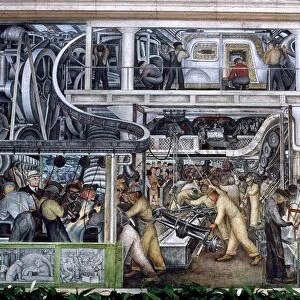
Glass Frame > North America > Honduras > Maps
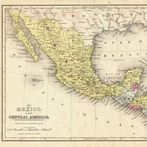
Glass Frame : Geography map: representation of the Yucatan ratings in southern Mexico and the Honduras coasts, made by Dutch cartographer Gerard van Keulen (1678-1726) 1709-1713. Biblioteca Angelica, Rome
 1709-1713. Biblioteca Angelica, Rome")
 1709-1713. Biblioteca Angelica, Rome")


![]()
Mounted Prints from Fine Art Finder
Geography map: representation of the Yucatan ratings in southern Mexico and the Honduras coasts, made by Dutch cartographer Gerard van Keulen (1678-1726) 1709-1713. Biblioteca Angelica, Rome
VEN5030127 Geography map: representation of the Yucatan ratings in southern Mexico and the Honduras coasts, made by Dutch cartographer Gerard van Keulen (1678-1726) 1709-1713. Biblioteca Angelica, Rome; (add.info.: Geography map: representation of the Yucatan ratings in southern Mexico and the Honduras coasts, made by Dutch cartographer Gerard van Keulen (1678-1726) 1709-1713. Biblioteca Angelica, Rome); © Marage Photos
Media ID 38167632
© © Marage Photos / Bridgeman Images
Amerique Centrale Amerique Du Nord Carte Geographique Central America Etats Unis Geographie Honduras Mexicans Mexico Mexican Mexique Stockravenna 18eme Siecle Geographical Map
7"x5" Glass Mount
Wall mounted or free-standing, these black edged glass frames feature a smooth chamfered edge and a stylish black border (on back face of the glass). Manufactured from 4mm thick glass, Glass Mounts are a durable, professional way of displaying and protecting your prints. Your 7x5 print is slotted into the back of the frame so can easily be changed if needed.
Tempered Glass Mounts are ideal for wall display, plus the smaller sizes can also be used free-standing via an integral stand
Estimated Image Size (if not cropped) is 17.7cm x 12.7cm (7" x 5")
Estimated Product Size is 20.3cm x 16.2cm (8" x 6.4")
These are individually made so all sizes are approximate
Artwork printed orientated as per the preview above, with landscape (horizontal) orientation to match the source image.
FEATURES IN THESE COLLECTIONS
> Fine Art Finder
> Artists
> Unknown Artist
> Maps and Charts
> Early Maps
> North America
> Honduras
> Maps
> North America
> Honduras
> Related Images
> North America
> Mexico
> Maps
> North America
> Mexico
> Related Images
> North America
> United States of America
> Maps
EDITORS COMMENTS
This stunning print showcases a geography map created by Dutch cartographer Gerard van Keulen between 1709-1713, depicting the Yucatan peninsula in southern Mexico and the coasts of Honduras. The intricate details and accuracy of this map are a testament to Van Keulen's skill and expertise in cartography during the early 18th century.
The map, housed in the Biblioteca Angelica in Rome, offers a glimpse into the geographical knowledge of that time period, highlighting important landmarks and coastal features of these regions. It serves as a valuable historical document, providing insight into how these areas were perceived and understood centuries ago.
Van Keulen's meticulous craftsmanship is evident in every line and symbol on this map, showcasing his dedication to accurately representing the landscape he was mapping. The combination of artistry and scientific precision makes this piece not only informative but also visually captivating.
As we study this geography map today, we can appreciate the legacy left behind by cartographers like Gerard van Keulen who played a crucial role in expanding our understanding of the world around us. This print serves as a reminder of their contributions to both science and artistry, preserving their work for future generations to admire and learn from.
MADE IN THE UK
Safe Shipping with 30 Day Money Back Guarantee
FREE PERSONALISATION*
We are proud to offer a range of customisation features including Personalised Captions, Color Filters and Picture Zoom Tools
SECURE PAYMENTS
We happily accept a wide range of payment options so you can pay for the things you need in the way that is most convenient for you
* Options may vary by product and licensing agreement. Zoomed Pictures can be adjusted in the Basket.