Premium Framed Print > Fine Art Finder > Maps (celestial & Terrestrial)
Premium Framed Print : Northern Europe, from an Atlas of the World in 33 maps, Venice, 1st September 1553


![]()
Framed Photos from Fine Art Finder
Northern Europe, from an Atlas of the World in 33 maps, Venice, 1st September 1553
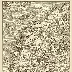
XOT330951 Northern Europe, from an Atlas of the World in 33 maps, Venice, 1st September 1553 (ink on vellum) (see also 330952) by Agnese, Battista (1514-64); 29x49 cm; Museo Correr, Venice, Italy; Italian, out of copyright
Media ID 12852670
© www.bridgemanart.com
Baltic Sea Chart Denmark Finland Iceland Mapping North Wind Norway Sea Monster Sweden
17"x15" (43x38cm) Premium Frame
FSC real wood frame with double mounted 10x8 print. Double mounted with white conservation mountboard. Frame moulding comprises stained composite natural wood veneers (Finger Jointed Pine) 39mm wide by 21mm thick. Archival quality Fujifilm CA photo paper mounted onto 1mm card. Overall outside dimensions are 17x15 inches (431x381mm). Rear features Framing tape to cover staples, 50mm Hanger plate, cork bumpers. Glazed with durable thick 2mm Acrylic to provide a virtually unbreakable glass-like finish. Acrylic Glass is far safer, more flexible and much lighter than typical mineral glass. Moreover, its higher translucency makes it a perfect carrier for photo prints. Acrylic allows a little more light to penetrate the surface than conventional glass and absorbs UV rays so that the image and the picture quality doesn't suffer under direct sunlight even after many years. Easily cleaned with a damp cloth. Please note that, to prevent the paper falling through the mount window and to prevent cropping of the original artwork, the visible print may be slightly smaller to allow the paper to be securely attached to the mount without any white edging showing and to match the aspect ratio of the original artwork.
FSC Real Wood Frame and Double Mounted with White Conservation Mountboard - Professionally Made and Ready to Hang
Estimated Image Size (if not cropped) is 24.4cm x 18.3cm (9.6" x 7.2")
Estimated Product Size is 43.1cm x 38.1cm (17" x 15")
These are individually made so all sizes are approximate
Artwork printed orientated as per the preview above, with landscape (horizontal) orientation to match the source image.
FEATURES IN THESE COLLECTIONS
> Fine Art Finder
> Artists
> Battista Agnese
> Fine Art Finder
> Maps (celestial & Terrestrial)
EDITORS COMMENTS
This print showcases a remarkable piece of cartography from the 16th century. Created by Battista Agnese in Venice on September 1st, 1553, this ink on vellum map offers a glimpse into Northern Europe as it was known during that time. Measuring at 29x49 cm, this intricate map is housed in the Museo Correr in Venice, Italy. It depicts various countries and regions including Scandinavia, England, Ireland, Iceland, Finland, Sweden, Norway, Denmark and the Baltic Sea. The level of detail is astonishing; one can observe tiny boats sailing across the sea and even fish swimming beneath its surface. What makes this artwork truly fascinating are the mythical elements incorporated within it. A menacing sea monster lurks near Iceland while a personification of North Wind blows fiercely above Scandinavia. These fantastical additions add an air of mystery to an otherwise factual representation. Agnese's mastery shines through his precise rendering of coastlines and meticulous labeling of cities and towns throughout Northern Europe. This historical artifact not only serves as a valuable resource for understanding past geographical knowledge but also provides insight into Renaissance-era cartography techniques. This print allows us to appreciate both the artistic skill involved in creating such maps as well as gain insights into how our ancestors perceived their world centuries ago.
MADE IN THE UK
Safe Shipping with 30 Day Money Back Guarantee
FREE PERSONALISATION*
We are proud to offer a range of customisation features including Personalised Captions, Color Filters and Picture Zoom Tools
SECURE PAYMENTS
We happily accept a wide range of payment options so you can pay for the things you need in the way that is most convenient for you
* Options may vary by product and licensing agreement. Zoomed Pictures can be adjusted in the Basket.