Glass Frame > Fine Art Finder > Maps (celestial & Terrestrial)
Glass Frame : Northern Europe, from an Atlas of the World in 33 maps, Venice, 1st September 1553


![]()
Mounted Prints from Fine Art Finder
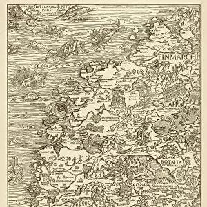
Northern Europe, from an Atlas of the World in 33 maps, Venice, 1st September 1553
XOT330951 Northern Europe, from an Atlas of the World in 33 maps, Venice, 1st September 1553 (ink on vellum) (see also 330952) by Agnese, Battista (1514-64); 29x49 cm; Museo Correr, Venice, Italy; Italian, out of copyright
Media ID 12852670
© www.bridgemanart.com
Baltic Sea Chart Denmark Finland Iceland Mapping North Wind Norway Sea Monster Sweden
7"x5" Glass Mount
Wall mounted or free-standing, these black edged glass frames feature a smooth chamfered edge and a stylish black border (on back face of the glass). Manufactured from 4mm thick glass, Glass Mounts are a durable, professional way of displaying and protecting your prints. Your 7x5 print is slotted into the back of the frame so can easily be changed if needed.
Tempered Glass Mounts are ideal for wall display, plus the smaller sizes can also be used free-standing via an integral stand
Estimated Image Size (if not cropped) is 17.7cm x 12.7cm (7" x 5")
Estimated Product Size is 20.3cm x 16.2cm (8" x 6.4")
These are individually made so all sizes are approximate
Artwork printed orientated as per the preview above, with landscape (horizontal) orientation to match the source image.
FEATURES IN THESE COLLECTIONS
> Fine Art Finder
> Artists
> Battista Agnese
> Fine Art Finder
> Maps (celestial & Terrestrial)
EDITORS COMMENTS
This print showcases a remarkable piece of cartography from the 16th century. Created by Battista Agnese in Venice on September 1st, 1553, this ink on vellum map offers a glimpse into Northern Europe as it was known during that time. Measuring at 29x49 cm, this intricate map is housed in the Museo Correr in Venice, Italy. It depicts various countries and regions including Scandinavia, England, Ireland, Iceland, Finland, Sweden, Norway, Denmark and the Baltic Sea. The level of detail is astonishing; one can observe tiny boats sailing across the sea and even fish swimming beneath its surface. What makes this artwork truly fascinating are the mythical elements incorporated within it. A menacing sea monster lurks near Iceland while a personification of North Wind blows fiercely above Scandinavia. These fantastical additions add an air of mystery to an otherwise factual representation. Agnese's mastery shines through his precise rendering of coastlines and meticulous labeling of cities and towns throughout Northern Europe. This historical artifact not only serves as a valuable resource for understanding past geographical knowledge but also provides insight into Renaissance-era cartography techniques. This print allows us to appreciate both the artistic skill involved in creating such maps as well as gain insights into how our ancestors perceived their world centuries ago.
MADE IN THE UK
Safe Shipping with 30 Day Money Back Guarantee
FREE PERSONALISATION*
We are proud to offer a range of customisation features including Personalised Captions, Color Filters and Picture Zoom Tools
SECURE PAYMENTS
We happily accept a wide range of payment options so you can pay for the things you need in the way that is most convenient for you
* Options may vary by product and licensing agreement. Zoomed Pictures can be adjusted in the Basket.