Poster Print > Arts > Artists > O > Abraham Ortelius
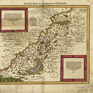
Poster Print : Orteliuss map of Ottoman Empire, 1570


![]()
Poster Prints from Science Photo Library
Orteliuss map of Ottoman Empire, 1570
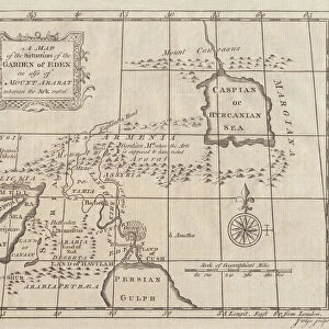
Orteliuss map of the Ottoman Empire. This map is from the 1570 first edition of Theatrum orbis terrarum ( Theatre of the World ). Drawn by the Flemish mapmaker Abraham Ortelius (1527-1598), and published by Gilles Coppens de Diest in Antwerp, this collection of 53 maps is considered to be the first true modern atlas
Science Photo Library features Science and Medical images including photos and illustrations
Media ID 6298063
© LIBRARY OF CONGRESS, GEOGRAPHY AND MAP DIVISION/SCIENCE PHOTO LIBRARY
1500s 1570 1570 Edition 16th Century Abraham Ortelius Africa African Age Of Discovery Antwerp Edition Arab Arabic Cartographic Cartography Country Dutch Empire First Edition First Modern Atlas Flemish Gilles Coppens De Diest Islamic Latin Latin Edition Middle East Moslem Muslim Nation Orteliuss Ottoman Empire Region Text Theatre Of The World Theatrum Orbis Terrarum Turkish Writing Ottoman
A2 (59.4 x 42cm) Poster Print
Introducing the Media Storehouse range of historic poster prints, featuring the Ortelius Map of the Ottoman Empire from 1570. This exquisite map is taken from the first edition of Theatrum orbis terrarum, or Theatre of the World, published by the renowned cartographer Abraham Ortelius. The map provides a fascinating glimpse into the geographic knowledge of the Ottoman Empire during the late 16th century. With intricate detail and vibrant colors, this poster print is a must-have for history enthusiasts, educators, and anyone with a passion for the exploration and mapping of our world. Bring the rich history of cartography into your home or office with this stunning and authentic reproduction.
A2 Poster (59.4 x 42cm, 23.4" x 16.5" inches) printed on 170gsm Satin Poster Paper. Securely packaged, rolled and inserted into a strong mailing tube and shipped tracked. Poster Prints are of comparable archival quality to our Photographic prints, they are simply printed on thinner Poster Paper. Whilst we only use Photographic Prints in our frames, you can frame Poster Prints if they are carefully supported to prevent sagging over time.
Poster prints are budget friendly enlarged prints in standard poster paper sizes (A0, A1, A2, A3 etc). Whilst poster paper is sometimes thinner and less durable than our other paper types, they are still ok for framing and should last many years. Our Archival Quality Photo Prints and Fine Art Paper Prints are printed on higher quality paper and the choice of which largely depends on your budget.
Estimated Image Size (if not cropped) is 56.7cm x 42cm (22.3" x 16.5")
Estimated Product Size is 59.4cm x 42cm (23.4" x 16.5")
These are individually made so all sizes are approximate
Artwork printed orientated as per the preview above, with landscape (horizontal) orientation to match the source image.
FEATURES IN THESE COLLECTIONS
> Africa
> Related Images
> Arts
> Artists
> O
> Abraham Ortelius
> Asia
> Related Images
> Asia
> Turkey
> Related Images
> Maps and Charts
> Abraham Ortelius
> Maps and Charts
> Early Maps
> Maps and Charts
> Popular Maps
> Maps and Charts
> Related Images
> Maps and Charts
> World
EDITORS COMMENTS
This print showcases Orteliuss map of the Ottoman Empire, a remarkable piece from the 1570 first edition of Theatrum orbis terrarum (Theatre of the World). Crafted by the talented Flemish cartographer Abraham Ortelius and published in Antwerp by Gilles Coppens de Diest, this collection of 53 maps is hailed as the pioneering modern atlas. Intricate details adorn this historical masterpiece, providing a glimpse into the world during the 16th century. The Latin text accompanying the map adds an air of authenticity to its composition. With its meticulous depiction of European, African, and Asian regions under Ottoman rule, it serves as a testament to both geographical accuracy and artistic finesse. Transporting us back in time, this artwork sheds light on an era marked by exploration and discovery. It offers valuable insights into how different nations coexisted within one empire - Muslim Arabs alongside Turks - showcasing their diverse cultures and histories. As we delve into this visual treasure trove brimming with history and geography intertwined, we are reminded that maps not only serve practical purposes but also hold immense cultural significance. This particular rendition provides a window into Europe's fascination with distant lands during the Age of Discovery while simultaneously capturing our imagination with its exquisite craftsmanship. Science Photo Library has once again brought forth an invaluable piece that invites us to explore our past through artistry and cartography.
MADE IN THE UK
Safe Shipping with 30 Day Money Back Guarantee
FREE PERSONALISATION*
We are proud to offer a range of customisation features including Personalised Captions, Color Filters and Picture Zoom Tools
SECURE PAYMENTS
We happily accept a wide range of payment options so you can pay for the things you need in the way that is most convenient for you
* Options may vary by product and licensing agreement. Zoomed Pictures can be adjusted in the Basket.