Home > Asia > Pakistan > Maps
Partition. Map of East and West Punjab

![]()
Wall Art and Photo Gifts from Mary Evans Picture Library
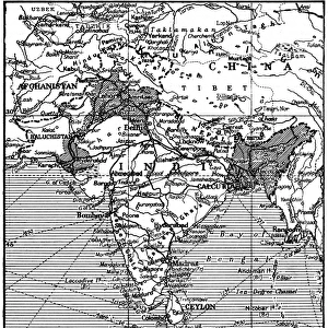
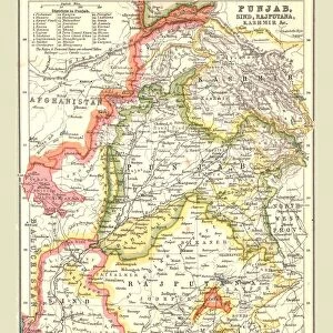
Partition. Map of East and West Punjab
The areas of the Western and Eastern Punjab where there were many outbreaks of violence between Muslims, Sikhs and Hindus following Partition and the creation of modern India and Pakistan
Mary Evans Picture Library makes available wonderful images created for people to enjoy over the centuries
Media ID 4410760
© Mary Evans Picture Library 2015 - https://copyrighthub.org/s0/hub1/creation/maryevans/MaryEvansPictureID/10238531
1947 Creation Exodus Hindu Hindus Muslim Muslims Pakistan Partition Punjab Sikh Sikhs Violence
FEATURES IN THESE COLLECTIONS
> Maps and Charts
> Early Maps
> Maps and Charts
> India
EDITORS COMMENTS
This evocative map print depicts the Eastern and Western regions of Punjab on the eve of the momentous event that would forever alter the political and demographic landscape of the Indian subcontinent. The year was 1947, and the partition of India and Pakistan was imminent. The map highlights the areas of intense violence and displacement that erupted between Muslims, Sikhs, and Hindus in the wake of this historical division. The Eastern and Western Punjab, shown in vibrant shades of red and green, were the epicenters of the chaos that ensued following the creation of modern India and Pakistan. The map serves as a stark reminder of the exodus that took place as millions of people were forced to leave their homes and cross the newly drawn borders, often facing unimaginable hardships and violence along the way. The map does not merely represent a geographical boundary but a tragic chapter in the history of the Indian subcontinent. The partition of Punjab led to the displacement of over 14 million people, making it one of the largest mass migrations in human history. The violence that erupted during this period claimed the lives of hundreds of thousands of people, leaving deep scars on the collective psyche of the region. This map print serves as a poignant reminder of the human cost of political divisions and the importance of understanding the complex historical context that shaped the modern nations of India and Pakistan. It is a testament to the resilience and determination of the people of the subcontinent, who have continued to rebuild their lives and communities in the face of adversity.
MADE IN THE UK
Safe Shipping with 30 Day Money Back Guarantee
FREE PERSONALISATION*
We are proud to offer a range of customisation features including Personalised Captions, Color Filters and Picture Zoom Tools
SECURE PAYMENTS
We happily accept a wide range of payment options so you can pay for the things you need in the way that is most convenient for you
* Options may vary by product and licensing agreement. Zoomed Pictures can be adjusted in the Basket.