Poster Print > Arts > Artists > C > Abraham Cresques
Poster Print : Catalan Atlas, 14th century


![]()
Poster Prints from Science Photo Library
Catalan Atlas, 14th century
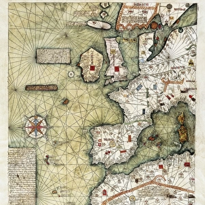
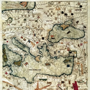
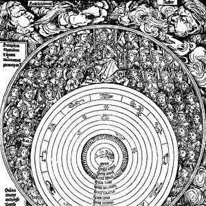
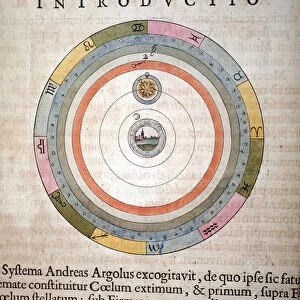
Catalan Atlas, 14th century. The 6-page Catalan Atlas (1375) was produced on vellum by the Jewish cartographer Abraham Cresques. It was commissioned by the rulers of the Kingdom of Aragon (north-eastern Spain). Two pages are on cosmography, and four on geography. This page shows the five known planets (plus the Moon and Sun) orbiting the Earth, the zodiac, moon phases, calendars, and the four seasons. The text is in Catalan. This version is a facsimile (exact reproduction) produced in 1959 by the Spanish scholars Joan Vernet and David Romano. The facsimile pages have been illuminated by hand in colour and gold leaf
Science Photo Library features Science and Medical images including photos and illustrations
Media ID 6345247
© LIBRARY OF CONGRESS/SCIENCE PHOTO LIBRARY
1300s 14th Century 1900s 1959 Autumn Calendar Cartographic Cartography Colour Cosmogony Cosmological Cosmology Geocentric Gold Leaf Illuminated Jewish Jupiter Mars Mediaeval Medieval Mercury Middle Ages Moon Planets Re Production Saturn Season Seasons Solar System Spain Spanish Spring Text Venus Winter Writing Zodiac 1375 Catalan Catalan Atlas Facsimile Mappa Mundi Ptolemaic System
A2 (59.4 x 42cm) Poster Print
Introducing the Media Storehouse collection of historic poster prints, featuring the enchanting Catalan Atlas from the Science Photo Library. Dated back to the 14th century, this exquisite map was meticulously crafted by Jewish cartographer Abraham Cresques on vellum. This six-page atlas is a captivating testament to the rich cartographic traditions of the Middle Ages. Bring the mysteries of ancient mapmaking into your home or office with our high-quality, museum-grade poster prints. Each print is printed on premium paper using archival inks, ensuring your investment will last for years to come. Transport yourself back in time and ignite your imagination with this stunning piece of cartographic history.
A2 Poster (59.4 x 42cm, 23.4" x 16.5" inches) printed on 170gsm Satin Poster Paper. Securely packaged, rolled and inserted into a strong mailing tube and shipped tracked. Poster Prints are of comparable archival quality to our Photographic prints, they are simply printed on thinner Poster Paper. Whilst we only use Photographic Prints in our frames, you can frame Poster Prints if they are carefully supported to prevent sagging over time.
Poster prints are budget friendly enlarged prints in standard poster paper sizes (A0, A1, A2, A3 etc). Whilst poster paper is sometimes thinner and less durable than our other paper types, they are still ok for framing and should last many years. Our Archival Quality Photo Prints and Fine Art Paper Prints are printed on higher quality paper and the choice of which largely depends on your budget.
Estimated Image Size (if not cropped) is 42cm x 55cm (16.5" x 21.7")
Estimated Product Size is 42cm x 59.4cm (16.5" x 23.4")
These are individually made so all sizes are approximate
Artwork printed orientated as per the preview above, with portrait (vertical) orientation to match the source image.
FEATURES IN THESE COLLECTIONS
> Arts
> Art Movements
> Medieval Art
> Arts
> Artists
> C
> Abraham Cresques
> Europe
> Spain
> Related Images
> Maps and Charts
> Early Maps
> Maps and Charts
> Spain
> Maps and Charts
> World
> Posters
> Scientific Posters
> Science
> Space Exploration
> Planets
> Earth
> Science
> Space Exploration
> Planets
> Jupiter
EDITORS COMMENTS
This print showcases the Catalan Atlas, a remarkable 14th-century masterpiece created by Abraham Cresques, a Jewish cartographer. Commissioned by the rulers of the Kingdom of Aragon in Spain, this six-page atlas was meticulously crafted on vellum and offers profound insights into cosmography and geography. In this particular page of the atlas, we are presented with an intricate depiction of our solar system. The five known planets at that time (Mercury, Venus, Mars, Jupiter, and Saturn), along with the Moon and Sun, gracefully orbit around Earth. Surrounding this celestial dance are details such as the zodiac signs, moon phases, calendars representing different seasons - spring to winter - all inscribed in Catalan. Although this version is a facsimile produced in 1959 by Spanish scholars Joan Vernet and David Romano, it faithfully captures every detail from the original work. The pages have been exquisitely illuminated by hand using vibrant colors and delicate gold leaf accents. The Catalan Atlas serves as a testament to humanity's fascination with both geographical exploration and astronomical understanding during medieval times. It represents an invaluable piece of history that not only reflects Catalonia's rich cultural heritage but also provides valuable insights into how people perceived their place within the cosmos centuries ago.
MADE IN THE UK
Safe Shipping with 30 Day Money Back Guarantee
FREE PERSONALISATION*
We are proud to offer a range of customisation features including Personalised Captions, Color Filters and Picture Zoom Tools
SECURE PAYMENTS
We happily accept a wide range of payment options so you can pay for the things you need in the way that is most convenient for you
* Options may vary by product and licensing agreement. Zoomed Pictures can be adjusted in the Basket.