Postcard > Europe > France > Canton > Landes
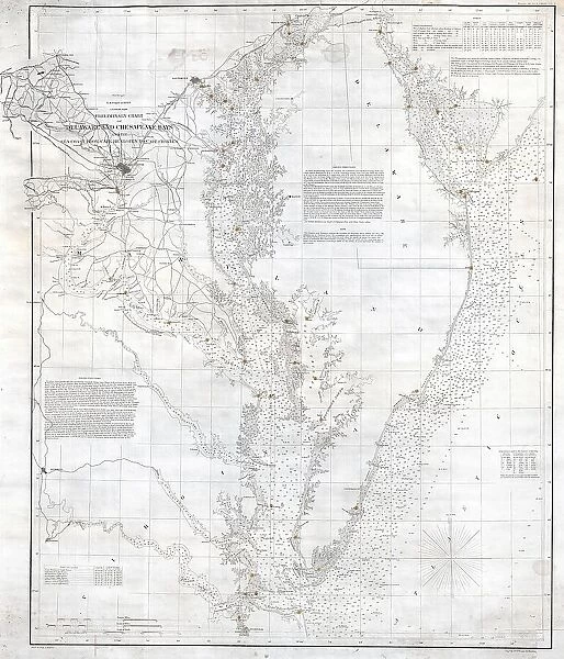
Postcard : 1855 U.S. Coast Survey Nautical Chart Or Map Of The Chesapeake Bay
![]()

Cards from Universal Images Group (UIG)
1855 U.S. Coast Survey Nautical Chart Or Map Of The Chesapeake Bay
1855, U.S. Coast Survey Nautical Chart or Map of the Chesapeake Bay
Universal Images Group (UIG) manages distribution for many leading specialist agencies worldwide
Media ID 38551428
© Artokoloro Quint Lox Limited
1855 Antique Map Latitude Longitude Mappa Mundi Old Antique Plan Old Antique View Ols Antique Map Rare Old Maps Topo
Postcards (8 pack of A6)
Set of 8, A6 Postcards, featuring the same image on all cards in a set. Printed on 350gsm premium white satin card, the back of the postcard includes space to write messages and an area for the address and stamp. Size of each postcard is 15cm x 10.6cm.
Photo postcards are a great way to stay in touch with family and friends.
Estimated Product Size is 10.6cm x 15cm (4.2" x 5.9")
These are individually made so all sizes are approximate
Artwork printed orientated as per the preview above, with landscape (horizontal) or portrait (vertical) orientation to match the source image.
FEATURES IN THESE COLLECTIONS
> Animals
> Fishes
> G
> Grouper
> Europe
> France
> Canton
> Landes
> Historic
> Space exploration
> Maps and Charts
> Early Maps
> Maps and Charts
> Related Images
> Maps and Charts
> World
> Universal Images Group (UIG)
> History
> Historical Maps
EDITORS COMMENTS
Step back in time to the mid-19th century with this stunning 1855 U.S. Coast Survey Nautical Chart of the Chesapeake Bay. This vintage map is a treasure trove of geographical and historical significance, offering a glimpse into the region's rich maritime heritage.
The chart is a masterclass in cartography, featuring intricate details of the bay's shoreline, waterways, and surrounding landscape. The grid system and latitude-longitude coordinates provide a sense of precision and accuracy, while the illustrations of lighthouses, buoys, and other navigational aids offer insight into the challenges faced by sailors and traders who traversed these waters.
This beautiful print is not only a fascinating piece of history but also an impressive work of art. The aged paper has developed a unique patina over time, giving it an air of nostalgia and character that adds to its charm. Whether you're an historian, cartography enthusiast or simply someone who appreciates vintage aesthetics, this map is sure to captivate.
As you gaze upon this historic chart, imagine yourself on board one of the many vessels that once sailed these waters - trading goods between Europe and America or exploring new territories along the eastern seaboard. Let your imagination run wild as you navigate through time to an era when exploration was at its peak.
MADE IN THE UK
Safe Shipping with 30 Day Money Back Guarantee
FREE PERSONALISATION*
We are proud to offer a range of customisation features including Personalised Captions, Color Filters and Picture Zoom Tools
SECURE PAYMENTS
We happily accept a wide range of payment options so you can pay for the things you need in the way that is most convenient for you
* Options may vary by product and licensing agreement. Zoomed Pictures can be adjusted in the Basket.


