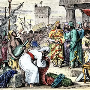
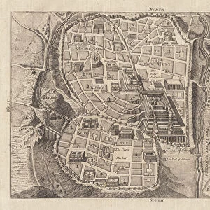
Postcard > Asia > Lebanon > Lebanon Heritage Sites > Tyre
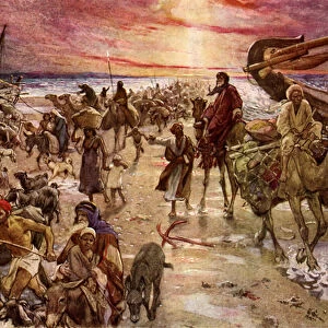
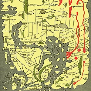
Postcard : Map of ancient Palestine kingdoms of Judah and Israel


![]()
Cards from North Wind
Map of ancient Palestine kingdoms of Judah and Israel
Map of Phoenicia and Judea in the time of King Solomon, 10th century BC.
Hand-colored woodcut of a 19th-century illustration
North Wind Picture Archives brings history to life with stock images and hand-colored illustrations
Media ID 5877781
© North Wind Picture Archives
African Ancient Ancient History Biblical City Holy Land Israel Jewish King Solomon Lebanon Mediterranean Mediterranean Sea Mid East Middle East Old Testament Palestine Phoenicia Phoenician Sea Port Solomon Syria Tyre 10th Century Bc Gaza Sidon
Postcards (8 pack of A6)
Set of 8, A6 Postcards, featuring the same image on all cards in a set. Printed on 350gsm premium white satin card, the back of the postcard includes space to write messages and an area for the address and stamp. Size of each postcard is 15cm x 10.6cm.
Photo postcards are a great way to stay in touch with family and friends.
Estimated Product Size is 10.6cm x 15cm (4.2" x 5.9")
These are individually made so all sizes are approximate
Artwork printed orientated as per the preview above, with landscape (horizontal) or portrait (vertical) orientation to match the source image.
FEATURES IN THESE COLLECTIONS
> North Wind Picture Archives
> Ancient history
> North Wind Picture Archives
> Maps
> Africa
> Related Images
> Arts
> Artists
> S
> Syrian Syrian
> Asia
> East Timor
> Maps
> Asia
> East Timor
> Related Images
> Asia
> Israel
> Related Images
> Asia
> Lebanon
> Lebanon Heritage Sites
> Tyre
> Asia
> Lebanon
> Related Images
EDITORS COMMENTS
This hand-colored woodcut print showcases a mesmerizing map of ancient Palestine, specifically the kingdoms of Judah and Israel during the reign of King Solomon in the 10th century BC. The intricate illustration takes us on a journey through time, providing a glimpse into the historic cities and regions that once thrived in this biblical land. The vintage aesthetic adds an air of authenticity to this remarkable piece of art. As we study the map, we are transported back to an era where African influences from Tyre and Phoenicia intertwined with Jewish heritage, creating a rich tapestry of cultures along the Mediterranean Sea. The strategic sea ports such as Sidon and Gaza come alive on this map, reminding us of their significance in trade routes connecting Syria, Lebanon, and beyond. It is fascinating to witness how these ancient civilizations flourished amidst political complexities within the Middle East. As we delve deeper into history through this visual masterpiece, it serves as a reminder of our collective past and its impact on shaping our present world. This depiction not only offers insights into Old Testament narratives but also sheds light on ancient Israel's connections with neighboring lands like Edom. With every glance at this extraordinary artwork capturing centuries-old stories etched onto paper, we gain a renewed appreciation for the rich tapestry that is human history.
MADE IN THE UK
Safe Shipping with 30 Day Money Back Guarantee
FREE PERSONALISATION*
We are proud to offer a range of customisation features including Personalised Captions, Color Filters and Picture Zoom Tools
SECURE PAYMENTS
We happily accept a wide range of payment options so you can pay for the things you need in the way that is most convenient for you
* Options may vary by product and licensing agreement. Zoomed Pictures can be adjusted in the Basket.