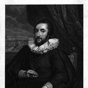
Photographic Print > Arts > Artists > R > Francois Rabelais
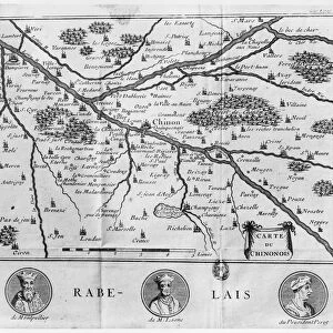
Photographic Print : Map of the French Department of Indre-et-Loire - No. 37


![]()
Photo Prints from Mary Evans Picture Library
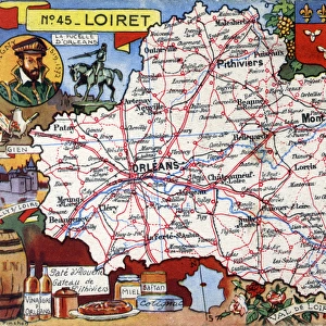
Map of the French Department of Indre-et-Loire - No. 37
Map of the French Department of Indre-et-Loire - No.37, featuring inset illustrations of Chenonceaux, Langeais, Loches, Amboise and portraits of Rene Descartes, French philosopher, mathematician, and scientist, dubbed the father of modern philosophy and Francois Rabelais, a major French Renaissance writer, physician, Renaissance humanist, monk and Greek scholar.
circa 1910s
Mary Evans Picture Library makes available wonderful images created for people to enjoy over the centuries
Media ID 14363912
© The Roseries Collection / Mary Evans Picture Library
Amboise Chart Chateau Chateaux Chenonceaux Department Descartes Francois Humanist Indre Loire Major Mathematician Monk Philosopher Philosophy Physician Plan Rabelais Renaissance Rene Scholar Scientist Indre Et Loire Langeais Loches
10"x8" (25x20cm) Photo Print
Discover the rich history and beauty of Indre-et-Loire, France, with this exquisite photographic print from Media Storehouse and The Roseries Collection, exclusively available at Mary Evans Prints Online. This captivating map, part of The Roseries Collection from Mary Evans Picture Library, showcases the French department of Indre-et-Loire in intricate detail. With inset illustrations of notable towns such as Chenonceaux, Langeais, Loches, and Amboise, this print transports you back in time. Adding to the historical charm, the map features portraits of renowned French philosopher and mathematician, Rene Descartes. Bring a piece of French heritage into your home or office with this stunning, high-quality photographic print.
Printed on archival quality paper for unrivalled stable artwork permanence and brilliant colour reproduction with accurate colour rendition and smooth tones. Printed on professional 234gsm Fujifilm Crystal Archive DP II paper. 10x8 for landscape images, 8x10 for portrait images.
Our Photo Prints are in a large range of sizes and are printed on Archival Quality Paper for excellent colour reproduction and longevity. They are ideal for framing (our Framed Prints use these) at a reasonable cost. Alternatives include cheaper Poster Prints and higher quality Fine Art Paper, the choice of which is largely dependant on your budget.
Estimated Image Size (if not cropped) is 17.9cm x 25.4cm (7" x 10")
Estimated Product Size is 20.3cm x 25.4cm (8" x 10")
These are individually made so all sizes are approximate
Artwork printed orientated as per the preview above, with portrait (vertical) orientation to match the source image.
FEATURES IN THESE COLLECTIONS
> Arts
> Art Movements
> Renaissance Art
> Arts
> Artists
> R
> Francois Rabelais
> Arts
> Contemporary art
> Modern art
> Portraits
> Arts
> Contemporary art
> Portraits
> Modern art
> Arts
> Street art graffiti
> Portraits
> Fine art
> Arts
> Street art graffiti
> Portraits
> Modern art
> Europe
> France
> Canton
> Indre
> Europe
> France
> Canton
> Loire
EDITORS COMMENTS
This elegant and intricately detailed map print, titled 'Map of the French Department of Indre-et-Loire - No. 37,' dates back to the 1910s. The map provides an extensive and accurate representation of the Indre-et-Loire department in France, located in the Centre-Val de Loire region. The map is adorned with charming inset illustrations of some of the most notable towns and châteaux within the department, including Chenonceaux, Langeais, Loches, and Amboise. Chenonceaux, depicted in the upper left corner, is famous for its unique architecture, with a portion of the castle arching gracefully over the Cher River. Langeais, shown in the lower left, is home to a magnificent fortress and was once a favorite residence of the French monarchy. Loches, illustrated in the lower right, boasts a stunning château and is known for its beautiful gardens and historic significance. Amboise, located in the upper right, was a favorite residence of King Francis I and is home to the Royal Château d'Amboise. The map also features portraits of two renowned figures associated with Indre-et-Loire: Rene Descartes and Francois Rabelais. Descartes, the father of modern philosophy, mathematics, and science, is depicted in the upper left corner, while Rabelais, a major French Renaissance writer, physician, humanist, monk, and Greek scholar, is shown in the lower right. This beautiful map print offers a captivating glimpse into the rich history and cultural significance of Indre-et-Loire, making it a must-have for anyone with an interest in French history, geography, or art.
MADE IN THE UK
Safe Shipping with 30 Day Money Back Guarantee
FREE PERSONALISATION*
We are proud to offer a range of customisation features including Personalised Captions, Color Filters and Picture Zoom Tools
SECURE PAYMENTS
We happily accept a wide range of payment options so you can pay for the things you need in the way that is most convenient for you
* Options may vary by product and licensing agreement. Zoomed Pictures can be adjusted in the Basket.