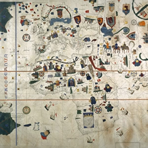
Photographic Print : Chart by Juan de la Cosa (1500). SPAIN. Madrid
. SPAIN. Madrid")
![]()
Photo Prints from Mary Evans Picture Library
Chart by Juan de la Cosa (1500). SPAIN. Madrid
Chart by Juan de la Cosa (1500). SPAIN. Madrid. Navy Museum
Mary Evans Picture Library makes available wonderful images created for people to enjoy over the centuries
Media ID 8275163
© Mary Evans Picture Library 2015 - https://copyrighthub.org/s0/hub1/creation/maryevans/MaryEvansPictureID/10683537
Artistic Beaux C Ulture Cartographic Cartographies Cartography Chart Cosa Geographic Geographical Geography Juan Maps Navigation Sail
12"x8" (30x20cm) Photo Print
Introducing the captivating addition to our Media Storehouse range of Photographic Prints: "Chart by Juan de la Cosa (1500). SPAIN. Madrid" from Mary Evans Prints Online. This exquisite image showcases an intriguing historical artifact - a world map created by the renowned cartographer Juan de la Cosa in 1500. Hailing from Madrid, Spain, this chart is now preserved in the Navy Museum, a testament to the rich cartographic history and exploration of the past. Our high-quality photographic print brings the intricate details of this ancient map to your home or office, making it an exceptional conversation starter and a beautiful work of art. Experience the allure of the unknown and the marvels of cartography with this stunning piece from Media Storehouse.
Printed on archival quality paper for unrivalled stable artwork permanence and brilliant colour reproduction with accurate colour rendition and smooth tones. Printed on professional 234gsm Fujifilm Crystal Archive DP II paper. 12x8 for landscape images, 8x12 for portrait images.
Our Photo Prints are in a large range of sizes and are printed on Archival Quality Paper for excellent colour reproduction and longevity. They are ideal for framing (our Framed Prints use these) at a reasonable cost. Alternatives include cheaper Poster Prints and higher quality Fine Art Paper, the choice of which is largely dependant on your budget.
Estimated Image Size (if not cropped) is 30.4cm x 15.4cm (12" x 6.1")
Estimated Product Size is 30.5cm x 20.3cm (12" x 8")
These are individually made so all sizes are approximate
Artwork printed orientated as per the preview above, with landscape (horizontal) orientation to match the source image.
EDITORS COMMENTS
This stunning chart, created by the Spanish cartographer Juan de la Cosa in 1500, is a testament to the rich maritime history of Spain during the Age of Discovery. Housed in the Navy Museum in Madrid, this exquisite piece of cartography is a fine example of the artistic and geographical advancements made during this period of intensive navigation and exploration. The chart, which measures approximately 1.2 meters in diameter, is adorned with intricate illustrations of various coastal regions and islands, meticulously detailed and colorfully rendered. The map covers the western Atlantic Ocean, from the northernmost tip of Europe to the southernmost tip of South America. It includes the Iberian Peninsula, the Canary Islands, the coasts of North and South America, and the Caribbean islands. Juan de la Cosa, a navigator and cartographer in the service of the Spanish Crown, created this chart to aid in the exploration and conquest of new lands. The chart's accuracy and detail were crucial for the success of Spanish expeditions, as they allowed navigators to plot their courses and identify potential ports and harbors. This chart is a significant cultural artifact, showcasing the interconnectedness of the world during the Age of Discovery. It reflects the Spanish Empire's growing influence and dominance in the Atlantic world, as well as the advancements made in cartography and navigation during this period. The intricate illustrations and precise cartography demonstrate the artistic and geographical achievements of Juan de la Cosa and his contemporaries, making this chart a valuable addition to the collections of the Navy Museum in Madrid.
MADE IN THE UK
Safe Shipping with 30 Day Money Back Guarantee
FREE PERSONALISATION*
We are proud to offer a range of customisation features including Personalised Captions, Color Filters and Picture Zoom Tools
SECURE PAYMENTS
We happily accept a wide range of payment options so you can pay for the things you need in the way that is most convenient for you
* Options may vary by product and licensing agreement. Zoomed Pictures can be adjusted in the Basket.