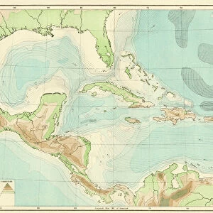
Photographic Print : 1855, Colton Map of Florida, topography, cartography, geography, land, illustration


![]()
Photo Prints from Liszt Collection
1855, Colton Map of Florida, topography, cartography, geography, land, illustration
1855, Colton Map of Florida
Liszt Collection of nineteenth-century engravings and images to browse and enjoy
Media ID 14007470
© Artokoloro Quint Lox Limited
1855 Antique Map Latitude Longitude Mappa Mundi Old Antique Plan Old Antique View Ols Antique Map Rare Old Maps Topo
10"x8" (25x20cm) Photo Print
Discover the captivating history of Florida with our exquisite 1855 Colton Map of Florida print from the Liszt Collection. This stunning piece of cartographic art showcases intricate topographical details, illustrating the geographical features of the Sunshine State during a pivotal period in its history. With meticulous attention to cartographic accuracy, this vintage map transports you back in time, offering a unique perspective on Florida's rich past. Add this beautiful, museum-quality print to your home or office to ignite conversations and inspire a deeper appreciation for the evolution of geography and land exploration.
Printed on archival quality paper for unrivalled stable artwork permanence and brilliant colour reproduction with accurate colour rendition and smooth tones. Printed on professional 234gsm Fujifilm Crystal Archive DP II paper. 10x8 for landscape images, 8x10 for portrait images.
Our Photo Prints are in a large range of sizes and are printed on Archival Quality Paper for excellent colour reproduction and longevity. They are ideal for framing (our Framed Prints use these) at a reasonable cost. Alternatives include cheaper Poster Prints and higher quality Fine Art Paper, the choice of which is largely dependant on your budget.
Estimated Product Size is 25.4cm x 20.3cm (10" x 8")
These are individually made so all sizes are approximate
Artwork printed orientated as per the preview above, with landscape (horizontal) orientation to match the source image.
EDITORS COMMENTS
This print showcases the intricate details of the 1855 Colton Map of Florida, a true masterpiece in cartography. The topography and geography of this southern state are beautifully illustrated, offering a glimpse into its land formations and natural features. This vintage map, with its ancient charm and historical significance, takes us back to a time when exploration and discovery were at their peak. The carefully crafted lines on this paper relic form an impressive grid system that denotes latitude and longitude coordinates, allowing for precise navigation across Florida's diverse regions. Its geometric precision is reminiscent of mappa mundi maps from centuries ago, adding an extra layer of fascination to this piece. As we delve into the past through this old antique view, we can't help but appreciate the artistry behind it. The decorative elements incorporated into the design make it not only informative but also aesthetically pleasing. It serves as a reminder of how maps were once cherished as valuable artifacts documenting our world's history. With its aged appearance and historic allure, this rare old map transports us to another era—a time when Florida was still being explored and understood by early settlers. Whether you're an avid collector or simply intrigued by historical relics like these, this print offers a unique window into our planet's past that is sure to captivate any viewer.
MADE IN THE UK
Safe Shipping with 30 Day Money Back Guarantee
FREE PERSONALISATION*
We are proud to offer a range of customisation features including Personalised Captions, Color Filters and Picture Zoom Tools
SECURE PAYMENTS
We happily accept a wide range of payment options so you can pay for the things you need in the way that is most convenient for you
* Options may vary by product and licensing agreement. Zoomed Pictures can be adjusted in the Basket.