Fine Art Print : 1855, Colton Map of Florida, topography, cartography, geography, land, illustration


![]()
Fine Art Prints from Liszt Collection
1855, Colton Map of Florida, topography, cartography, geography, land, illustration
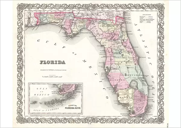
1855, Colton Map of Florida
Liszt Collection of nineteenth-century engravings and images to browse and enjoy
Media ID 14007470
© Artokoloro Quint Lox Limited
1855 Antique Map Latitude Longitude Mappa Mundi Old Antique Plan Old Antique View Ols Antique Map Rare Old Maps Topo
A2 (42x59cm) Fine Art Print
Discover the rich history of Florida with our exquisite Fine Art Print from the Media Storehouse collection. This captivating 1855 Colton Map of Florida showcases intricate topography, cartography, and geography details. Each line and contour is meticulously rendered, inviting you on a journey back in time. The illustration, sourced from the esteemed Liszt Collection, adds an extra layer of historical significance. Bring this stunning piece of cartographic art into your home or office and let it inspire your imagination. Experience the beauty and depth of Florida's past with our Fine Art Print.
Our Fine Art Prints are printed on 100% acid free, PH neutral paper with archival properties. This printing method is used by museums and art collections to exhibit photographs and art reproductions. Hahnemühle certified studio for digital fine art printing. Printed on 308gsm Photo Rag Paper.
Our fine art prints are high-quality prints made using a paper called Photo Rag. This 100% cotton rag fibre paper is known for its exceptional image sharpness, rich colors, and high level of detail, making it a popular choice for professional photographers and artists. Photo rag paper is our clear recommendation for a fine art paper print. If you can afford to spend more on a higher quality paper, then Photo Rag is our clear recommendation for a fine art paper print.
Estimated Image Size (if not cropped) is 51.3cm x 42cm (20.2" x 16.5")
Estimated Product Size is 59.4cm x 42cm (23.4" x 16.5")
These are individually made so all sizes are approximate
Artwork printed orientated as per the preview above, with landscape (horizontal) orientation to match the source image.
EDITORS COMMENTS
This print showcases the intricate details of the 1855 Colton Map of Florida, a true masterpiece in cartography. The topography and geography of this southern state are beautifully illustrated, offering a glimpse into its land formations and natural features. This vintage map, with its ancient charm and historical significance, takes us back to a time when exploration and discovery were at their peak. The carefully crafted lines on this paper relic form an impressive grid system that denotes latitude and longitude coordinates, allowing for precise navigation across Florida's diverse regions. Its geometric precision is reminiscent of mappa mundi maps from centuries ago, adding an extra layer of fascination to this piece. As we delve into the past through this old antique view, we can't help but appreciate the artistry behind it. The decorative elements incorporated into the design make it not only informative but also aesthetically pleasing. It serves as a reminder of how maps were once cherished as valuable artifacts documenting our world's history. With its aged appearance and historic allure, this rare old map transports us to another era—a time when Florida was still being explored and understood by early settlers. Whether you're an avid collector or simply intrigued by historical relics like these, this print offers a unique window into our planet's past that is sure to captivate any viewer.
MADE IN THE UK
Safe Shipping with 30 Day Money Back Guarantee
FREE PERSONALISATION*
We are proud to offer a range of customisation features including Personalised Captions, Color Filters and Picture Zoom Tools
SECURE PAYMENTS
We happily accept a wide range of payment options so you can pay for the things you need in the way that is most convenient for you
* Options may vary by product and licensing agreement. Zoomed Pictures can be adjusted in the Basket.