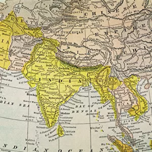
Photographic Print : 1801, Cary Map of Persia, Iran, Iraq, Afghanistan, John Cary, 1754 - 1835, English cartographer


![]()
Photo Prints from Liszt Collection
1801, Cary Map of Persia, Iran, Iraq, Afghanistan, John Cary, 1754 - 1835, English cartographer
Liszt Collection of nineteenth-century engravings and images to browse and enjoy
Media ID 14004873
© Artokoloro Quint Lox Limited
1754 1835 1754 – 1835 17541835 1801 Afghanistan English Cartographer Iran Iraq John Cary Antique Map Latitude Longitude Mappa Mundi Old Antique Plan Old Antique View Ols Antique Map Rare Old Maps Topo
10"x8" (25x20cm) Photo Print
Step back in time with our exquisite selection from the Media Storehouse range of Photographic Prints. This captivating piece showcases the 1801 Cary Map of Persia, Iran, Iraq, and Afghanistan. Meticulously crafted by renowned English cartographer John Cary in 1754, this rare and intriguing map offers a unique glimpse into the historical geography of the region. The rich details and vibrant colors of this antique map are brought to life in our high-quality photographic print, making it an essential addition to any home or office. Elevate your decor and transport yourself on a journey through history with this stunning piece.
Printed on archival quality paper for unrivalled stable artwork permanence and brilliant colour reproduction with accurate colour rendition and smooth tones. Printed on professional 234gsm Fujifilm Crystal Archive DP II paper. 10x8 for landscape images, 8x10 for portrait images.
Our Photo Prints are in a large range of sizes and are printed on Archival Quality Paper for excellent colour reproduction and longevity. They are ideal for framing (our Framed Prints use these) at a reasonable cost. Alternatives include cheaper Poster Prints and higher quality Fine Art Paper, the choice of which is largely dependant on your budget.
Estimated Product Size is 25.4cm x 20.3cm (10" x 8")
These are individually made so all sizes are approximate
Artwork printed orientated as per the preview above, with landscape (horizontal) orientation to match the source image.
EDITORS COMMENTS
This print showcases the remarkable "1801, Cary Map of Persia, Iran, Iraq, Afghanistan" created by the talented English cartographer John Cary (1754 - 1835). As an expert in his field, Cary meticulously crafted this map with precision and attention to detail. The map offers a fascinating glimpse into the topography and geography of these ancient lands. Its intricate illustration captures the diverse regions and their unique characteristics. With its grid lines denoting latitude and longitude, it serves as a valuable tool for navigation and exploration. With its vintage appeal and historical significance, this old antique map transports us back in time to an era when cartography was both artistry and science. The aged paper adds a touch of authenticity while evoking a sense of nostalgia for those who appreciate history. As we gaze upon this decorative piece, we are reminded of the journeys taken by explorers who relied on maps like these to navigate unfamiliar territories. It is through such maps that they discovered new lands and expanded our understanding of the world. This rare gem from the Liszt Collection allows us to connect with our past while appreciating the skillful craftsmanship that went into creating such masterpieces. Whether displayed in homes or offices, this print serves as a testament to human curiosity about our planet's vast landscapes throughout history
MADE IN THE UK
Safe Shipping with 30 Day Money Back Guarantee
FREE PERSONALISATION*
We are proud to offer a range of customisation features including Personalised Captions, Color Filters and Picture Zoom Tools
SECURE PAYMENTS
We happily accept a wide range of payment options so you can pay for the things you need in the way that is most convenient for you
* Options may vary by product and licensing agreement. Zoomed Pictures can be adjusted in the Basket.