Photo Mug > Animals > Insects > Hemiptera > Hall Scale
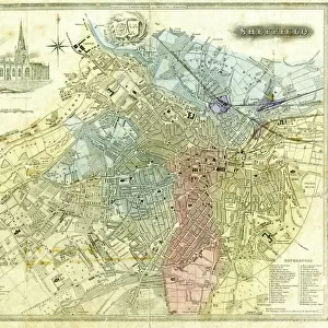
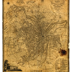
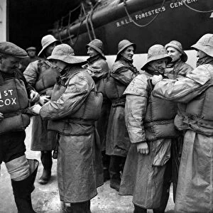
Photo Mug : A correct plan of the town of Sheffield by William Fairbank, 1771


![]()
Home Decor from Sheffield City Archives
A correct plan of the town of Sheffield by William Fairbank, 1771
Scale 440 yards : 3.3 inches.
Shows the Bull Stake, slaughterhouses, Town Mill, Irish Cross.
Original at Local Studies y09647
Sheffield City Archives and Local Studies Library has an unrivalled collection of images of Sheffield, England
Media ID 14048645
© Sheffield City Council
Bridge Castle Chapel Company Corn Croft Cutlers Fairbank Hall Hill King Lane Little Maps Mill Mills Moor Norfolk Power River Rivers Sheffield Spring Square Street Tilt Waingate Walk Water Waterwheels Wheel Wicker Yorkshire Alley Alsop Brighouse Change Cheney Colson Crofts Dixon Folds Jehu Ladys Mulberry Newhall Orchard Pepper Pudding Simon
Photo Mug
Introducing the Media Storehouse Photo Mug featuring an intriguing historical image of "A Correct Plan of the Town of Sheffield by William Fairbank, 1771" from the Sheffield City Archives. This captivating design showcases the architectural details and landmarks of Sheffield as they appeared over 250 years ago. Bring a piece of local history into your daily routine with this high-quality mug. The classic shape and large image area provide an excellent canvas for this detailed, archival map. Discover the Bull Stake, slaughterhouses, Town Mill, and Irish Cross depicted in this meticulously crafted plan. Each Media Storehouse Photo Mug is made from durable ceramic material, ensuring a long-lasting and sturdy addition to your kitchenware collection. Impress your friends and family with this unique, historical mug that makes a perfect gift for history enthusiasts, locals, or anyone who appreciates the richness of the past. Embrace the essence of Sheffield's history and enjoy your favorite beverage in style with the Media Storehouse Photo Mug.
A personalised photo mug blends sentimentality with functionality, making an ideal gift for cherished loved ones, close friends, or valued colleagues. Preview may show both sides of the same mug.
Elevate your coffee or tea experience with our premium white ceramic mug. Its wide, comfortable handle makes drinking easy, and you can rely on it to be both microwave and dishwasher safe. Sold in single units, preview may show both sides of the same mug so you can see how the picture wraps around.
Mug Size is 9.5cm high x 8cm diameter (3.7" x 3.1")
These are individually made so all sizes are approximate
FEATURES IN THESE COLLECTIONS
> Animals
> Insects
> Hemiptera
> Hall Scale
> Arts
> Artists
> I
> William Ireland
> Europe
> Republic of Ireland
> Maps
> Europe
> United Kingdom
> England
> Norfolk
> Related Images
> Europe
> United Kingdom
> England
> Norfolk
> Mill Street
> Europe
> United Kingdom
> England
> Yorkshire
> Old Town
> Europe
> United Kingdom
> England
> Yorkshire
> Related Images
> Europe
> United Kingdom
> England
> Yorkshire
> Sheffield
> Europe
> United Kingdom
> England
> Yorkshire
> Street
> Europe
> United Kingdom
> England
> Yorkshire
> Woodlands
> Sheffield City Archives
> Maps and Plans
> Maps of Sheffield
EDITORS COMMENTS
This print showcases a historically significant map titled "A correct plan of the town of Sheffield" by William Fairbank, dating back to 1771. The intricate details and precision of this map offer a glimpse into the past, providing valuable insights into the layout and features of Sheffield during that era. The scale of 440 yards to 3.3 inches allows for a comprehensive view, highlighting notable landmarks such as the Bull Stake, slaughterhouses, Town Mill, and Irish Cross. These elements serve as reminders of Sheffield's rich industrial heritage. The original copy can be found at Local Studies y09647 in the esteemed Sheffield City Archives. This remarkable piece combines various elements like maps, wicker structures, tilt mechanisms, waterwheels powered by flowing water from Simon Wheel Woodlands Castle Orchard. As we explore further within this image's frame, we encounter familiar street names such as Dixon Lane Folds Waingate Pudding Brighouse King Pond Mill Union Cheney Square Pepper Alley Norfolk Chapel Walk Change Mulberry Jehu Ladys Bridge Irish Cross Newhall Colson Crofts Spring Croft Cutlers Hall Old Company River Don Rivers Corn Mills Alsop Fields Little Moor Yorkshire Fairbank). It is important to note that this photograph should not be used for commercial purposes; rather it serves as an invaluable resource for historical research and preservation.
MADE IN THE UK
Safe Shipping with 30 Day Money Back Guarantee
FREE PERSONALISATION*
We are proud to offer a range of customisation features including Personalised Captions, Color Filters and Picture Zoom Tools
SECURE PAYMENTS
We happily accept a wide range of payment options so you can pay for the things you need in the way that is most convenient for you
* Options may vary by product and licensing agreement. Zoomed Pictures can be adjusted in the Basket.