Home > Europe > United Kingdom > England > Yorkshire > Old Town
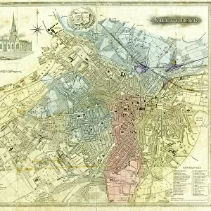
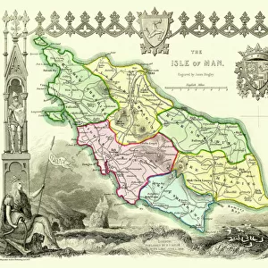
Old Map of Sheffield 1851 by John Tallis

![]()
Wall Art and Photo Gifts from MapSeeker
Old Map of Sheffield 1851 by John Tallis
A fine 1851 map by John Tallis of Victorian, industrial Sheffield in South Yorkshire that shows the steady growth of industry and housing to the left of the plan. There are two illustrations, of Sheffield from the south east and one of the Parish Church Sheffield
Welcome to the Mapseeker Image library and enter an historic gateway to one of the largest on-line collections of Historic Maps, Nostalgic Views, Vista's and Panorama's from a World gone by.
Media ID 20347616
Historic Map John Tallis John Tallis Map Old Town Plan Tallis Map Sheffield
FEATURES IN THESE COLLECTIONS
> Arts
> Artists
> T
> John Tallis
> Europe
> United Kingdom
> England
> South Yorkshire
> Related Images
> Europe
> United Kingdom
> England
> South Yorkshire
> Sheffield
> Europe
> United Kingdom
> England
> Yorkshire
> Old Town
> Europe
> United Kingdom
> England
> Yorkshire
> Related Images
> Europe
> United Kingdom
> England
> Yorkshire
> Sheffield
> Maps and Charts
> Related Images
> MapSeeker
> British Town And City Plans
> English & Welsh PORTFOLIO
EDITORS COMMENTS
This stunning print showcases an exquisite piece of history - the "Old Map of Sheffield 1851" by John Tallis. Transporting us back to Victorian times, this fine map provides a fascinating glimpse into the industrial city of Sheffield in South Yorkshire. The intricate details and craftsmanship highlight the steady growth of industry and housing on the left side of the plan. The map offers two captivating illustrations that further enrich our understanding of Sheffield's past. One illustration depicts a panoramic view of Sheffield from the southeast, allowing us to marvel at its architectural beauty and bustling streets. The other illustration features the Parish Church, a prominent landmark that stood as a testament to faith amidst rapid urbanization. As we explore this historic town plan, we are reminded of Sheffield's significant role in shaping Britain's industrial revolution. This meticulously crafted map not only serves as a visual guide but also sparks curiosity about how life must have been during this transformative era. Whether you are an avid historian or simply appreciate artistry, this print is sure to captivate your imagination. It serves as both a decorative piece for your home or office and an educational tool that transports you back in time to experience Victorian Sheffield through John Tallis' eyes.
MADE IN THE UK
Safe Shipping with 30 Day Money Back Guarantee
FREE PERSONALISATION*
We are proud to offer a range of customisation features including Personalised Captions, Color Filters and Picture Zoom Tools
SECURE PAYMENTS
We happily accept a wide range of payment options so you can pay for the things you need in the way that is most convenient for you
* Options may vary by product and licensing agreement. Zoomed Pictures can be adjusted in the Basket.