Photo Mug > Europe > France > Canton > Nord
Photo Mug : Le Djebel Nefousa; Le Nord-Est Africain, 1914. Creator: Unknown


![]()
Home Decor From Heritage Images
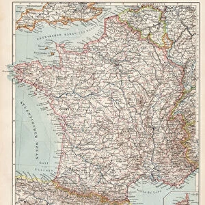
Le Djebel Nefousa; Le Nord-Est Africain, 1914. Creator: Unknown
Le Djebel Nefousa; Le Nord-Est Africain, 1914. From "Grande Geographie Bong Illustree", 1914
Heritage Images features heritage image collections
Media ID 36296357
© The Print Collector/Heritage Images
Cartography Libya Map Making Mapmaking
Photo Mug
Bring the enchanting beauty of the past into your daily routine with our Media Storehouse Photo Mugs. Featuring the captivating image "Le Djebel Nefousa; Le Nord-Est Africain," taken from Grande Geographie Bong Illustree in 1914, these mugs showcase the mystery and allure of a bygone era. With high-quality print technology, the vivid colors and intricate details of this historic photograph are beautifully preserved. Each mug holds your favorite beverage and serves as a unique conversation starter, allowing you to savor the past with every sip.
A personalised photo mug blends sentimentality with functionality, making an ideal gift for cherished loved ones, close friends, or valued colleagues. Preview may show both sides of the same mug.
Elevate your coffee or tea experience with our premium white ceramic mug. Its wide, comfortable handle makes drinking easy, and you can rely on it to be both microwave and dishwasher safe. Sold in single units, preview may show both sides of the same mug so you can see how the picture wraps around.
Mug Size is 8cm high x 9.5cm diameter (3.1" x 3.7")
These are individually made so all sizes are approximate
FEATURES IN THESE COLLECTIONS
> Africa
> Libya
> Related Images
> Europe
> France
> Canton
> Nord
> Maps and Charts
> Related Images
Le Djebel Nefousa; Le Nord-Est Africain,
EDITORS COMMENTS
a captivating and enigmatic map print from the early 20th century, transports us back in time to the unexplored territories of North-Eastern Africa. The creator of this masterpiece remains unknown, but it was published in the esteemed French geographical journal "Grande Geographie Bong Illustree" in 1914. This evocative map offers a glimpse into the cartographic explorations of the early 1900s, a time when the African continent was still being mapped and claimed by European powers. The map's title, "Le Djebel Nefousa; Le Nord-Est Africain," refers to the Jebel Nefousa mountain range in modern-day Libya, which forms a significant landmark in the region. The map's vibrant colors and intricate details bring the landscape to life, with the Sahara Desert depicted in shades of orange and brown, and the Nile River winding its way through the green expanse of Egypt. The map also highlights various locations of historical and geographical significance, such as the cities of Tripoli, Benghazi, and Alexandria, as well as the Red Sea and the Mediterranean Coast. The mapmaking process during this era was a testament to human curiosity and the desire to explore and understand the world around us. This print serves as a reminder of the rich history of cartography and the role it played in shaping our understanding of the world. The unknown creator of "Le Djebel Nefousa; Le Nord-Est Africain" has left us with a beautiful and intriguing piece of history that continues to fascinate and inspire.
MADE IN THE UK
Safe Shipping with 30 Day Money Back Guarantee
FREE PERSONALISATION*
We are proud to offer a range of customisation features including Personalised Captions, Color Filters and Picture Zoom Tools
SECURE PAYMENTS
We happily accept a wide range of payment options so you can pay for the things you need in the way that is most convenient for you
* Options may vary by product and licensing agreement. Zoomed Pictures can be adjusted in the Basket.