Photo Mug > Granger Art on Demand > Maps
Photo Mug : MAP: AFRICA, ARABIA, INDIA. Map of North and East Africa, Arabia, and part of India


![]()
Home Decor from Granger
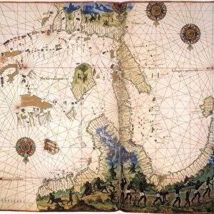
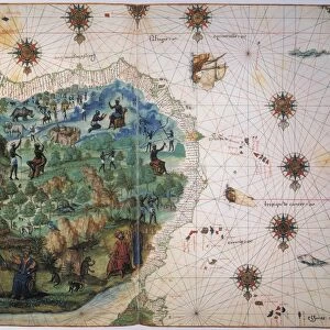
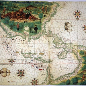
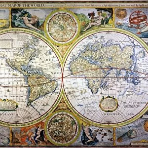
MAP: AFRICA, ARABIA, INDIA. Map of North and East Africa, Arabia, and part of India
MAP: AFRICA, ARABIA, INDIA.
Map of North and East Africa, Arabia, and part of India from the Vallard Atlas, c1547; the map, drawn upside-down as if viewed from Europe, depicts the legendary king of Abyssinia, Prester John
Granger holds millions of images spanning more than 25,000 years of world history, from before the Stone Age to the dawn of the Space Age
Media ID 12321010
1547 Arabia Arabian Asian Coastline Ethiopian India Portolan Chart Prester Topography Abyssinia
Photo Mug
Add a touch of world exploration to your daily routine with our Media Storehouse Photo Mugs. Featuring the captivating Map of Africa, Arabia, and India from the Vallard Atlas of 1547, these mugs showcase intricate details of North and East Africa, Arabia, and part of India. Each mug is printed with high-quality, vibrant images that bring the beauty of the world right to your hands. Perfect for tea or coffee, these mugs make for unique and thoughtful gifts for travel enthusiasts, history buffs, or anyone who appreciates the wonders of our diverse planet.
A personalised photo mug blends sentimentality with functionality, making an ideal gift for cherished loved ones, close friends, or valued colleagues. Preview may show both sides of the same mug.
Elevate your coffee or tea experience with our premium white ceramic mug. Its wide, comfortable handle makes drinking easy, and you can rely on it to be both microwave and dishwasher safe. Sold in single units, preview may show both sides of the same mug so you can see how the picture wraps around.
Mug Size is 8cm high x 9.5cm diameter (3.1" x 3.7")
These are individually made so all sizes are approximate
EDITORS COMMENTS
This print showcases a historical map titled "MAP: AFRICA, ARABIA, INDIA". Dating back to 1547 and sourced from the renowned Vallard Atlas, this map provides a unique perspective on North and East Africa, Arabia, and part of India. Interestingly, the cartographer chose to depict the map upside-down as if viewed from Europe. One notable feature of this ancient map is the depiction of the legendary king of Abyssinia known as Prester John. This mythical ruler adds an element of intrigue and mystery to an already fascinating piece. The intricate details captured in this print allow us to explore not only geographical aspects but also cultural connections between these regions during the Renaissance period. The visual representation includes significant landmarks such as coastlines, rivers, and topographical features that were crucial for navigation during that era. It offers a glimpse into how explorers perceived these territories centuries ago. As we delve into this historical artifact through Granger Art on Demand's lens, we are transported back in time when maps were hand-drawn with meticulous precision. This print serves as a reminder of our ever-evolving understanding of geography while honoring the craftsmanship behind ancient cartography.
MADE IN THE UK
Safe Shipping with 30 Day Money Back Guarantee
FREE PERSONALISATION*
We are proud to offer a range of customisation features including Personalised Captions, Color Filters and Picture Zoom Tools
SECURE PAYMENTS
We happily accept a wide range of payment options so you can pay for the things you need in the way that is most convenient for you
* Options may vary by product and licensing agreement. Zoomed Pictures can be adjusted in the Basket.