Fine Art Print > Granger Art on Demand > Maps
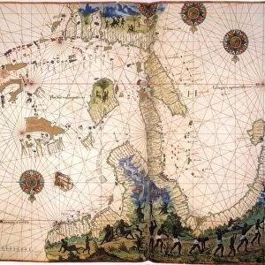
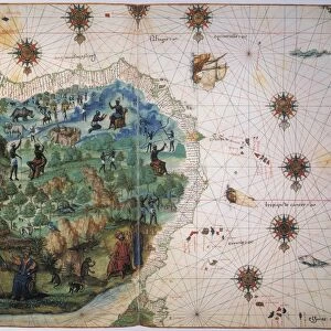
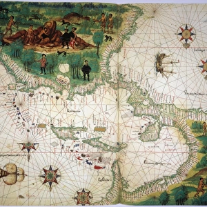
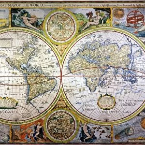
Fine Art Print : MAP: AFRICA, ARABIA, INDIA. Map of North and East Africa, Arabia, and part of India


![]()
Fine Art Prints from Granger
MAP: AFRICA, ARABIA, INDIA. Map of North and East Africa, Arabia, and part of India
MAP: AFRICA, ARABIA, INDIA.
Map of North and East Africa, Arabia, and part of India from the Vallard Atlas, c1547; the map, drawn upside-down as if viewed from Europe, depicts the legendary king of Abyssinia, Prester John
Granger holds millions of images spanning more than 25,000 years of world history, from before the Stone Age to the dawn of the Space Age
Media ID 12321010
1547 Arabia Arabian Asian Coastline Ethiopian India Portolan Chart Prester Topography Abyssinia
A2 (42x59cm) Fine Art Print
Discover the rich history and cultural diversity of Africa, Arabia, and India with our exquisite Fine Art Print from Media Storehouse. This captivating map, taken from the Vallard Atlas of 1547, showcases the intricate detail of the regions from that era. The upside-down perspective, as if viewed from Europe, adds an intriguing twist to this historical piece. Bring a touch of the old world into your home or office with this beautifully printed and framed map, a timeless addition to any decor.
Our Fine Art Prints are printed on 100% acid free, PH neutral paper with archival properties. This printing method is used by museums and art collections to exhibit photographs and art reproductions. Hahnemühle certified studio for digital fine art printing. Printed on 308gsm Photo Rag Paper.
Our fine art prints are high-quality prints made using a paper called Photo Rag. This 100% cotton rag fibre paper is known for its exceptional image sharpness, rich colors, and high level of detail, making it a popular choice for professional photographers and artists. Photo rag paper is our clear recommendation for a fine art paper print. If you can afford to spend more on a higher quality paper, then Photo Rag is our clear recommendation for a fine art paper print.
Estimated Image Size (if not cropped) is 59.4cm x 38.6cm (23.4" x 15.2")
Estimated Product Size is 59.4cm x 42cm (23.4" x 16.5")
These are individually made so all sizes are approximate
Artwork printed orientated as per the preview above, with landscape (horizontal) orientation to match the source image.
EDITORS COMMENTS
This print showcases a historical map titled "MAP: AFRICA, ARABIA, INDIA". Dating back to 1547 and sourced from the renowned Vallard Atlas, this map provides a unique perspective on North and East Africa, Arabia, and part of India. Interestingly, the cartographer chose to depict the map upside-down as if viewed from Europe. One notable feature of this ancient map is the depiction of the legendary king of Abyssinia known as Prester John. This mythical ruler adds an element of intrigue and mystery to an already fascinating piece. The intricate details captured in this print allow us to explore not only geographical aspects but also cultural connections between these regions during the Renaissance period. The visual representation includes significant landmarks such as coastlines, rivers, and topographical features that were crucial for navigation during that era. It offers a glimpse into how explorers perceived these territories centuries ago. As we delve into this historical artifact through Granger Art on Demand's lens, we are transported back in time when maps were hand-drawn with meticulous precision. This print serves as a reminder of our ever-evolving understanding of geography while honoring the craftsmanship behind ancient cartography.
MADE IN THE UK
Safe Shipping with 30 Day Money Back Guarantee
FREE PERSONALISATION*
We are proud to offer a range of customisation features including Personalised Captions, Color Filters and Picture Zoom Tools
SECURE PAYMENTS
We happily accept a wide range of payment options so you can pay for the things you need in the way that is most convenient for you
* Options may vary by product and licensing agreement. Zoomed Pictures can be adjusted in the Basket.