Photo Mug > Fine Art Storehouse > Map
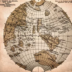
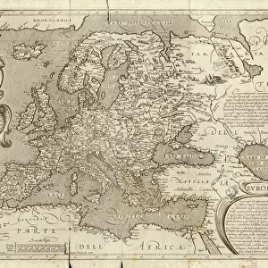
Photo Mug : Old, Black and White Illustration of Eastern Hemisphere, From 1800 s


![]()
Home Decor from Fine Art Storehouse
Old, Black and White Illustration of Eastern Hemisphere, From 1800 s
Old black and white illustration of the Old World (Eastern Hemisphere), from 1875
Unleash your creativity and transform your space into a visual masterpiece!
ideabug
Media ID 14777511
© ideabug
Arctic Ocean Atlantic Ocean Australia Chart Circle Continent Dirty Document East Eastern Hemisphere Ephemera Hemisphere Historical Document Image Created 1870 1879 Indian Ocean Intricacy Island Old World Outline Pacific Ocean Paper Peninsula Sepia Toned Shape Square Stained Topographic Map Topography World Map 1875 Antarctic Sea Image Created 19th Century Obsolete
Photo Mug
Step back in time with our Media Storehouse Photo Mug featuring an exquisite old black and white illustration of the Eastern Hemisphere from the 1870s. This captivating design, sourced from the Fine Art Storehouse, showcases a captivating old world charm. Each mug holds your favorite beverage while offering a daily dose of history and art. Perfect for history buffs, art enthusiasts, or anyone who appreciates the beauty of the past, this mug is sure to bring a touch of timeless elegance to your daily routine.
A personalised photo mug blends sentimentality with functionality, making an ideal gift for cherished loved ones, close friends, or valued colleagues. Preview may show both sides of the same mug.
Elevate your coffee or tea experience with our premium white ceramic mug. Its wide, comfortable handle makes drinking easy, and you can rely on it to be both microwave and dishwasher safe. Sold in single units, preview may show both sides of the same mug so you can see how the picture wraps around.
Mug Size is 9.5cm high x 8cm diameter (3.7" x 3.1")
These are individually made so all sizes are approximate
FEATURES IN THESE COLLECTIONS
> Fine Art Storehouse
> Map
> Historical Maps
EDITORS COMMENTS
This black and white illustration takes us back in time to the 1800s, offering a glimpse into the Eastern Hemisphere as it was perceived over a century ago. The image, created in 1875, showcases an intricate and detailed depiction of the Old World's topography and physical geography. As we examine this historical document, we can see the stained paper that has aged with time, giving it an authentic vintage feel. The sepia-toned square-shaped print reveals continents such as Asia, Europe, Africa, Australia, along with various islands and peninsulas scattered across oceans like the Pacific, Indian, Atlantic, and Arctic. The artist's attention to detail is evident in every stroke of this antique illustration. From the delicate outlines of each landmass to the carefully crafted cartographic elements such as sea charts and topographic maps - all contribute to its overall beauty. Though slightly faded and worn from years gone by, this old-world map still holds immense charm. It serves not only as a reminder of our planet's ever-changing landscape but also as a testament to humanity's fascination with exploration and discovery. This remarkable piece of ephemera transports us back in time while simultaneously reminding us how far we have come since then. A true treasure for history enthusiasts or anyone captivated by the allure of travel destinations from days long past.
MADE IN THE UK
Safe Shipping with 30 Day Money Back Guarantee
FREE PERSONALISATION*
We are proud to offer a range of customisation features including Personalised Captions, Color Filters and Picture Zoom Tools
SECURE PAYMENTS
We happily accept a wide range of payment options so you can pay for the things you need in the way that is most convenient for you
* Options may vary by product and licensing agreement. Zoomed Pictures can be adjusted in the Basket.