Fraud Blocker Skip to main content

Eastern Hemisphere Collection

The Eastern Hemisphere, a captivating realm of history and diversity, unfolds before our eyes

Background imageEastern Hemisphere Collection: World eastern hemispheres 1883

World eastern hemispheres 1883
Warrens Common School Geography

Background imageEastern Hemisphere Collection: 3D rendering of planet Earth, centered on Africa and Europe

3D rendering of planet Earth, centered on Africa and Europe
3D rendering of planet Earth with clouds, centered on Africa and Europe

Background imageEastern Hemisphere Collection: Old, Map of Eastern and Western Hemispheres, From 1875

Old, Map of Eastern and Western Hemispheres, From 1875
Old black and white illustration of the Eastern Hemisphere and the Western Hemisphere, from the 1800 s

Background imageEastern Hemisphere Collection: The World (colour litho)

The World (colour litho)
5207115 The World (colour litho) by American School, (19th century); Private Collection; (add.info.: The World. Illustration for Farrows Military Encyclopedia by Edwards Farrow)

Background imageEastern Hemisphere Collection: Map of the Eastern Hemisphere (coloured engraving)

Map of the Eastern Hemisphere (coloured engraving)
6014056 Map of the Eastern Hemisphere (coloured engraving) by American School, (19th century); Private Collection; (add.info.: Map of the Eastern Hemisphere)

Background imageEastern Hemisphere Collection: Old, Black and White Illustration of Eastern Hemisphere, From 1800 s

Old, Black and White Illustration of Eastern Hemisphere, From 1800 s
Old black and white illustration of the Old World (Eastern Hemisphere), from 1875

Background imageEastern Hemisphere Collection: Eastern hemisphere map 1881

Eastern hemisphere map 1881
Harpers School Geography, New York, Harpers and Brothers, 1881

Background imageEastern Hemisphere Collection: 3D rendering of planet Earth centered on Atlantic Ocean

3D rendering of planet Earth centered on Atlantic Ocean
3D rendering of planet Earth with clouds, centered on the Atlantic Ocean, with North America, South America, Africa and Europe partially visible

Background imageEastern Hemisphere Collection: 3D rendering of planet Earth with clouds, Oceania view

3D rendering of planet Earth with clouds, Oceania view

Background imageEastern Hemisphere Collection: Stylized Earth globe with grid, showing Oceania and Australia

Stylized Earth globe with grid, showing Oceania and Australia

Background imageEastern Hemisphere Collection: World map dating from the late 17th or early 18th century and published in Amsterdam showing

World map dating from the late 17th or early 18th century and published in Amsterdam showing the western and eastern hemispheres. Amongst many inaccuracies, the California area is shown as an island

Background imageEastern Hemisphere Collection: Eastern Hemisphere, Asia

Eastern Hemisphere, Asia

Background imageEastern Hemisphere Collection: Eastern Hemisphere 1852 Map

Eastern Hemisphere 1852 Map

Background imageEastern Hemisphere Collection: Map Of Eastern Hemisphere, 1492

Map Of Eastern Hemisphere, 1492
Map of the Eastern Hemisphere from Behaims Globe, 1492. (Kean Collection/Getty Images)

Background imageEastern Hemisphere Collection: 3D rendering of planet Earth with clouds, centered on Asia

3D rendering of planet Earth with clouds, centered on Asia

Background imageEastern Hemisphere Collection: Blue Marble image of Earth (2005)

Blue Marble image of Earth (2005)
Blue Marble image of Earth. Composite satellite image of Earths eastern hemisphere, centred on the Indian Ocean. North is at top

Background imageEastern Hemisphere Collection: africa, animals, antique, archival, art, asia, australia, border, cartography, continents

africa, animals, antique, archival, art, asia, australia, border, cartography, continents, culture, decorative, depicted, depicting, depiction, diversity, document, eastern hemisphere, europe

Background imageEastern Hemisphere Collection: Map drawing Africa North America Australia hemispheres 1881

Map drawing Africa North America Australia hemispheres 1881
Warrens Common School Geography

Background imageEastern Hemisphere Collection: World in zones hemispheres 1881

World in zones hemispheres 1881
Coltons Common School Geography 1881 New York Sheldon and Co

Background imageEastern Hemisphere Collection: Map drawing technique 1881

Map drawing technique 1881
Coltons Common School Geography 1881 New York Sheldon and Co

Background imageEastern Hemisphere Collection: The world in hemispheres map 1875

The world in hemispheres map 1875
The Independent Course Comprehensive Geography by James Monteith, A.S. Barnes & Co, New York & Chicago 1875

Background imageEastern Hemisphere Collection: Easter hemisphere map 1867

Easter hemisphere map 1867
Mitchellas Modern Atlas - Published by E.H. Butler and Co - Philadelphia 1867

Background imageEastern Hemisphere Collection: A synthesized view of Earth showing the Arctic, Europe and Asia

A synthesized view of Earth showing the Arctic, Europe and Asia

Background imageEastern Hemisphere Collection: Stylized Earth globe with grid, showing Asia and Europe

Stylized Earth globe with grid, showing Asia and Europe

Background imageEastern Hemisphere Collection: Composite image of the eastern hemisphere on planet Earth

Composite image of the eastern hemisphere on planet Earth
March 30, 2014 - Composite image of the eastern hemisphere on planet Earth

Background imageEastern Hemisphere Collection: Full Earth showing Europe and Asia

Full Earth showing Europe and Asia (with stars)

Background imageEastern Hemisphere Collection: Full Earth at night showing city lights of Asia and Australia

Full Earth at night showing city lights of Asia and Australia

Background imageEastern Hemisphere Collection: Full Earth from space above the African continent

Full Earth from space above the African continent

Background imageEastern Hemisphere Collection: Earth from space showing eastern hemisphere

Earth from space showing eastern hemisphere

Background imageEastern Hemisphere Collection: View of the Earth from space showing the eastern hemisphere

View of the Earth from space showing the eastern hemisphere

Background imageEastern Hemisphere Collection: Full Earth Showing Africa and Europe during the day

Full Earth Showing Africa and Europe during the day

Background imageEastern Hemisphere Collection: A full view of Earth showing global data for land surface, polar sea ice, and chlorophyll

A full view of Earth showing global data for land surface, polar sea ice, and chlorophyll
A view of the full Earth containing layers of global data for everything from the land surface, to polar sea ice, to the light reflected by the chlorophyll in the billions of microscopic plants that

Background imageEastern Hemisphere Collection: Artists concept comparing the size of Mars with that of the Earth

Artists concept comparing the size of Mars with that of the Earth. Mars diameter is half that of the Earth s, it has ten percent the mass and is 1.5 times the distance from the Sun

Background imageEastern Hemisphere Collection: Full Earth at night showing city lights centered on Europe

Full Earth at night showing city lights centered on Europe

Background imageEastern Hemisphere Collection: A global view over Europe and Scandinavia with Arctic sea ice

A global view over Europe and Scandinavia with Arctic sea ice shown on March 9, 2006. Land areas display the average seasonal landcover from March, 2004

Background imageEastern Hemisphere Collection: Full Earth at night showing Africa and Europe

Full Earth at night showing Africa and Europe

Background imageEastern Hemisphere Collection: 3D rendering of planet Earth with clouds, centered on Africa

3D rendering of planet Earth with clouds, centered on Africa

Background imageEastern Hemisphere Collection: View of Earth 650 million years ago during the Marinoan glaciation

View of Earth 650 million years ago during the Marinoan glaciation
This is how the Earth may have appeared about 650 million years ago during a period when snow and ice may have covered most, if not all, of the Earths surface and oceans

Background imageEastern Hemisphere Collection: Global view of Earth over North Africa, Europe, the Middle East, and India

Global view of Earth over North Africa, Europe, the Middle East, and India

Background imageEastern Hemisphere Collection: Digitally enhanced image of the full Earth with a lightening bolt

Digitally enhanced image of the full Earth with a lightening bolt

Background imageEastern Hemisphere Collection: 3D rendering of planet Earth, centered on the Pacific Ocean

3D rendering of planet Earth, centered on the Pacific Ocean
3D rendering of planet Earth with clouds, centered on the Pacific Ocean

Background imageEastern Hemisphere Collection: Full Earth showing evaporation over the Atlantic Ocean and the surrounding continents

Full Earth showing evaporation over the Atlantic Ocean and the surrounding continents during the daylight hours

Background imageEastern Hemisphere Collection: 3D rendering of planet Earth, centered on Europe

3D rendering of planet Earth, centered on Europe
3D rendering of planet Earth with clouds, centered on Europe

Background imageEastern Hemisphere Collection: Full view of the Earth showing topographic data

Full view of the Earth showing topographic data
Full view of the Earth derived from AVHRR and topographic data

Background imageEastern Hemisphere Collection: Full Earth showing city lights of Africa, Europe, and the Middle East

Full Earth showing city lights of Africa, Europe, and the Middle East

Background imageEastern Hemisphere Collection: Full Earth at night showing city lights centered on Asia

Full Earth at night showing city lights centered on Asia

Background imageEastern Hemisphere Collection: Planet Earth inside supermarket trolley

Planet Earth inside supermarket trolley. Africa, Europe and Asia view, white background

Background imageEastern Hemisphere Collection: Stylized Earth globe with grid, showing Europe and Africa

Stylized Earth globe with grid, showing Europe and Africa


All Professionally Made to Order for Quick Shipping

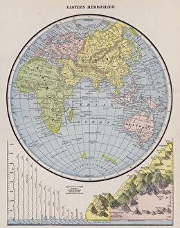
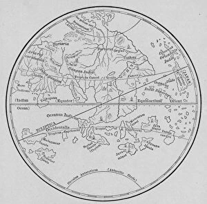
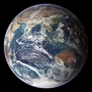
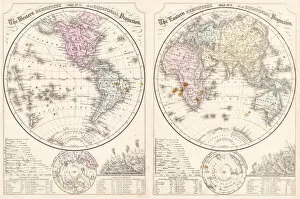
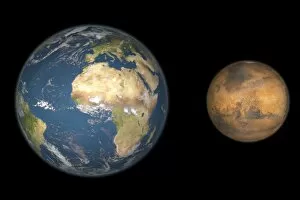
The Eastern Hemisphere, a captivating realm of history and diversity, unfolds before our eyes. Travel back to 1883 as we explore the World's eastern hemispheres through an intricate map from 1881. Witness the beauty of our planet Earth in a stunning 3D rendering, with Africa and Europe at its heart. Immerse yourself in the past with "The World" lithograph, bursting with vibrant colors that bring life to every continent. Delve deeper into cartography as you study an enchanting colored engraving showcasing the intricacies of the Eastern Hemisphere. Step even further back in time to the 1800s, where an old black and white illustration reveals a glimpse of this ancient world. Marvel at an antique map from 1875 depicting both Eastern and Western Hemispheres, each holding their own secrets waiting to be discovered. Venture into Africa's vast landscapes teeming with majestic animals while traversing Asia's rich cultural tapestry. Embark on a journey through Australia's untamed wilderness and witness borders merging continents together seamlessly. As we shift perspectives towards the Atlantic Ocean-centered view in another mesmerizing 3D rendering, let us not forget history's quirks. An intriguing world map dating back centuries displays inaccuracies like California portrayed as an island – reminding us of humanity's evolving understanding of geography. Finally, focus your attention solely on Asia within the Eastern Hemisphere - a land steeped in tradition yet ever-changing. And for those who seek historical accuracy, delve into a meticulously crafted map from 1852 that captures this hemisphere during its transformative era. In this amalgamation of archival artistry and geographical wonders lies our fascination with the Eastern Hemisphere - forever inviting exploration across time and space.