Photo Mug > Africa > Egypt > Maps
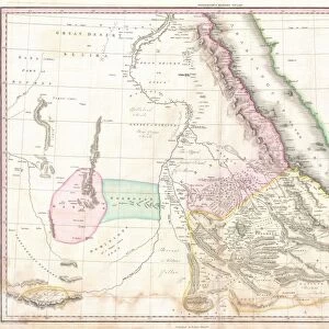
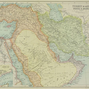
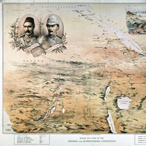
Photo Mug : Antique map of Middle East with Arabia, Egypt, Nubia, and Abyssinia


![]()
Home Decor from Fine Art Storehouse
Antique map of Middle East with Arabia, Egypt, Nubia, and Abyssinia
Unleash your creativity and transform your space into a visual masterpiece!
Hemera Technologies
Media ID 13609417
© Getty Images
Abyssinia Arabia Border Coordinates Direction Document Egypt Ethiopia Geography Horn Horn Of Africa Indian Ocean Israel Jordan Jordan Middle East Latitude Legend Libya Location Longitude Middle East Nile River Nubia Persian Gulf Place Positioning Red Sea Scale Sudan Lybia
Photo Mug
Add a touch of history to your daily routine with our Media Storehouse Photo Mug featuring an exquisite antique map of the Middle East. This beautifully detailed map, sourced from the Fine Art Storehouse by Hemera Technologies, showcases the ancient lands of Arabia, Egypt, Nubia, and Abyssinia. Each sip from this high-quality mug brings a journey through time, making it a unique and thoughtful gift for history enthusiasts or anyone who appreciates the beauty of the past. Embrace the rich history of the Middle East with every use.
A personalised photo mug blends sentimentality with functionality, making an ideal gift for cherished loved ones, close friends, or valued colleagues. Preview may show both sides of the same mug.
Elevate your coffee or tea experience with our premium white ceramic mug. Its wide, comfortable handle makes drinking easy, and you can rely on it to be both microwave and dishwasher safe. Sold in single units, preview may show both sides of the same mug so you can see how the picture wraps around.
Mug Size is 8cm high x 9.5cm diameter (3.1" x 3.7")
These are individually made so all sizes are approximate
FEATURES IN THESE COLLECTIONS
> Fine Art Storehouse
> Map
> Historical Maps
> Africa
> Egypt
> Related Images
> Africa
> Ethiopia (Abyssinia)
> Maps
> Africa
> Ethiopia (Abyssinia)
> Related Images
> Africa
> Ethiopia
> Related Images
> Africa
> Libya
> Related Images
> Africa
> Related Images
> Africa
> Sudan
> Related Images
EDITORS COMMENTS
This antique map of the Middle East takes us on a journey through time, unraveling the rich history and geography of this fascinating region. Printed by Hemera Technologies, it showcases Arabia, Egypt, Nubia, and Abyssinia in intricate detail. The map's archival quality transports us back to an era when cartography was both an art form and a scientific endeavor. Its delicate engravings depict borders, coordinates, and legends that guide our exploration. From the Persian Gulf to the Red Sea and from Israel to Sudan, every place is meticulously labeled with its longitude and latitude. As we trace the Nile River snaking through Egypt or follow the Horn of Africa jutting into the Indian Ocean, we are reminded of how physical geography has shaped civilizations over centuries. The absence of people in this image allows us to focus solely on nature's influence on human history. With its warm color palette and horizontal composition, this vintage print exudes a sense of nostalgia that invites contemplation. It serves as a reminder that understanding our past is essential for comprehending our present reality. Whether you are an avid historian or simply appreciate fine art photography, this antique map offers endless possibilities for discovery. Let it transport you across ancient lands while igniting your curiosity about cultures long gone but not forgotten.
MADE IN THE UK
Safe Shipping with 30 Day Money Back Guarantee
FREE PERSONALISATION*
We are proud to offer a range of customisation features including Personalised Captions, Color Filters and Picture Zoom Tools
SECURE PAYMENTS
We happily accept a wide range of payment options so you can pay for the things you need in the way that is most convenient for you
* Options may vary by product and licensing agreement. Zoomed Pictures can be adjusted in the Basket.