Photo Mug > Europe > United Kingdom > England > London > Towns > The Hyde
Photo Mug : Historic map of London


![]()
Home Decor from Fine Art Storehouse
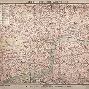
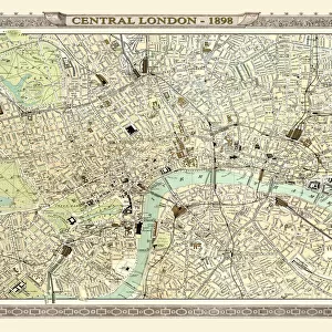
Historic map of London
Antique illustration map map/plan of the inner city of London from 1898
Unleash your creativity and transform your space into a visual masterpiece!
Nikola Nastasic
Media ID 13591679
© Nikola Nastasic
1890 1899 60595 66698 78279 City Map City Of London City Of Westminster Greater London Hyde Park London Image Created 1890 1899 Inner London Inside Inside Of Kensington And Chelsea Lambeth London England Navigational Equipment Northern Europe Regents Park Sepia Toned Southeast England Styles Thames River Thoroughfare Urban Road Urban Scene Vignette Image Created 19th Century Obsolete Retro Styled Victorian Style
Photo Mug
Add a touch of history to your daily routine with our Media Storehouse Photo Mugs featuring an exquisite antique illustration map of London by Nikola Nastasic from our Fine Art Storehouse collection. This historic map, dating back to 1898, showcases the inner city of London in intricate detail, making each sip from this mug a journey through time. Perfect for tea or coffee, these high-quality mugs not only keep your beverages warm but also serve as a unique conversation starter. Bring a piece of the past into your present and relive the charm of London's rich history with every use.
A personalised photo mug blends sentimentality with functionality, making an ideal gift for cherished loved ones, close friends, or valued colleagues. Preview may show both sides of the same mug.
Elevate your coffee or tea experience with our premium white ceramic mug. Its wide, comfortable handle makes drinking easy, and you can rely on it to be both microwave and dishwasher safe. Sold in single units, preview may show both sides of the same mug so you can see how the picture wraps around.
Mug Size is 8cm high x 9.5cm diameter (3.1" x 3.7")
These are individually made so all sizes are approximate
FEATURES IN THESE COLLECTIONS
> Fine Art Storehouse
> The Magical World of Illustration
> Nastasic Images & Illustrations
> Fine Art Storehouse
> Map
> Historical Maps
> Europe
> United Kingdom
> England
> London
> Boroughs
> City of London
> Europe
> United Kingdom
> England
> London
> Towns
> The Hyde
EDITORS COMMENTS
This print showcases a historic map of London, taking us back to the enchanting streets and landmarks of the city in 1898. With its antique illustration style, this retro cartography piece exudes the charm and elegance of the 19th century. The vignette effect adds a touch of nostalgia, transporting us to a bygone era. Engraved with precision and attention to detail, this image captures the essence of Victorian London. From Regents Park to Hyde Park, City of Westminster to Lambeth, Kensington and Chelsea to City of London, every neighborhood is meticulously depicted on this fascinating city map. It offers a glimpse into the past, revealing how urban scenes have evolved over time. The sepia-toned hues further enhance the vintage appeal while evoking a sense of history and tradition. As we explore this engraving's intricate lines and symbols, we can almost imagine navigating through these old streets using antiquated navigational equipment. With its horizontal layout and impressive size (measuring at 614407902 pixels), this print allows for an immersive experience as we delve into London's rich heritage. Whether you are an avid historian or simply appreciate art that tells stories from another time, Nikola Nastasic's creation will transport you back in time to witness London as it once was – bustling with life along the banks of River Thames and within its labyrinthine roads.
MADE IN THE UK
Safe Shipping with 30 Day Money Back Guarantee
FREE PERSONALISATION*
We are proud to offer a range of customisation features including Personalised Captions, Color Filters and Picture Zoom Tools
SECURE PAYMENTS
We happily accept a wide range of payment options so you can pay for the things you need in the way that is most convenient for you
* Options may vary by product and licensing agreement. Zoomed Pictures can be adjusted in the Basket.