Home > Europe > United Kingdom > England > London > Towns > Hither Green
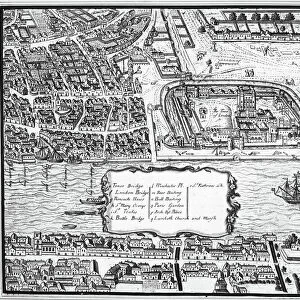
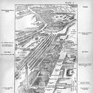
London Map, 1804

![]()
Wall Art and Photo Gifts from Mary Evans Picture Library
London Map, 1804
A map of London, showing the Westminster-Piccadilly area in 1804. Date: 1804
Mary Evans Picture Library makes available wonderful images created for people to enjoy over the centuries
Media ID 14127874
© Mary Evans Picture Library
1804 Berkeley Westminster Picadilly
FEATURES IN THESE COLLECTIONS
> Europe
> United Kingdom
> England
> London
> Boroughs
> City of Westminster
> Europe
> United Kingdom
> England
> London
> Towns
> Hither Green
> Europe
> United Kingdom
> England
> Maps
> Europe
> United Kingdom
> England
> Westminster
> Maps and Charts
> Early Maps
EDITORS COMMENTS
1. Title: A Glimpse into the Past: A Detailed Map of London's Westminster-Piccadilly Area in 1804 2. Description: This print showcases an intricately detailed map of London's Westminster-Piccadilly area as it appeared in 1804. The map, created by the renowned cartographer James Wyld, offers a fascinating glimpse into the history of one of the world's most iconic cities. 3. Setting the Scene: The map transports us back in time to the early 19th century, an era marked by the Regency period and the height of the British Empire. London, the bustling metropolis, was undergoing significant growth and transformation. 4. Key Features: The map highlights several prominent landmarks and structures that were integral to London's urban fabric during that period. These include the iconic Westminster Bridge, St. James's Park, Green Park, Berkeley Square, and Piccadilly. 5. Historical Context: Westminster Bridge, completed in 1750, was a marvel of engineering and connected the South Bank of the Thames to the Houses of Parliament. St. James's Park, established in 1532, served as a royal hunting ground and later became a popular recreational space for Londoners. 6. The Regency Quarter: The map also reveals the layout of the fashionable Regency quarter, with its elegant squares and grand houses. Berkeley Square, a favorite among the aristocracy, is depicted in meticulous detail, showcasing its picturesque gardens and impressive architecture. 7. Piccadilly Circus: The map also features Piccadilly, a fashionable shopping street that was home to numerous shops, inns, and theatres. The area around Piccadilly Circus was a hub of activity, with its vibrant markets and lively social scene. 8. Conclusion: This beautifully preserved map offers a unique perspective on London's rich history and serves as an invaluable resource for historians, urban planners, and anyone interested in the evolution of one of the world's most historic cities.
MADE IN THE UK
Safe Shipping with 30 Day Money Back Guarantee
FREE PERSONALISATION*
We are proud to offer a range of customisation features including Personalised Captions, Color Filters and Picture Zoom Tools
FREE COLORIZATION SERVICE
You can choose advanced AI Colorization for this picture at no extra charge!
SECURE PAYMENTS
We happily accept a wide range of payment options so you can pay for the things you need in the way that is most convenient for you
* Options may vary by product and licensing agreement. Zoomed Pictures can be adjusted in the Basket.