Mouse Mat > Europe > United Kingdom > Wales > Maps
Mouse Mat : 1796 Cary Folding Case Map Of England And Wales


![]()
Home Decor from Universal Images Group (UIG)
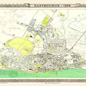
1796 Cary Folding Case Map Of England And Wales
1796, Cary Folding Case Map of England and Wales, John Cary, 1754 - 1835, English cartographer
Universal Images Group (UIG) manages distribution for many leading specialist agencies worldwide
Media ID 38548321
© Artokoloro Quint Lox Limited
1754 – 1835 1796 English Cartographer John Cary Antique Map Latitude Longitude Mappa Mundi Old Antique Plan Old Antique View Ols Antique Map Rare Old Maps Topo
Mouse Mat
A high quality photographic print manufactured into a durable wipe clean mouse mat (27x22cm) with a non slip backing, which works with all mice.
Archive quality photographic print in a durable wipe clean mouse mat with non slip backing. Works with all computer mice
Estimated Image Size (if not cropped) is 21cm x 25.4cm (8.3" x 10")
Estimated Product Size is 21.8cm x 26.9cm (8.6" x 10.6")
These are individually made so all sizes are approximate
Artwork printed orientated as per the preview above, with portrait (vertical) orientation to match the source image.
FEATURES IN THESE COLLECTIONS
> Animals
> Fishes
> G
> Grouper
> Europe
> France
> Canton
> Landes
> Europe
> United Kingdom
> England
> Maps
> Europe
> United Kingdom
> Wales
> Maps
> Europe
> United Kingdom
> Wales
> Related Images
> Historic
> Space exploration
> Maps and Charts
> Early Maps
> Maps and Charts
> Related Images
> Maps and Charts
> Wales
> Maps and Charts
> World
EDITORS COMMENTS
Step back in time to the late 18th century with this stunning print of John Cary's 1796 Folding Case Map of England and Wales. This beautifully detailed map is a testament to the cartographer's skill and dedication to capturing the intricate topography of the region.
Measuring approximately [insert dimensions], this map is a treasure trove of geographical information, featuring roads, rivers, towns, and cities. The map also includes latitude and longitude lines, providing a sense of scale and precision that was revolutionary for its time.
The folding case design allows for easy portability, making it an ideal companion for travelers and explorers venturing into the English countryside. The worn edges and aged paper give this print a unique vintage charm, as if it has been passed down through generations.
This historic map is not only a beautiful piece of art but also a valuable resource for historians, geographers, and anyone fascinated by the evolution of cartography. It serves as a reminder of our shared human desire to understand and navigate our surroundings.
Hang this magnificent print in your home or office as a conversation starter or use it as inspiration for your next adventure.
MADE IN THE UK
Safe Shipping with 30 Day Money Back Guarantee
FREE PERSONALISATION*
We are proud to offer a range of customisation features including Personalised Captions, Color Filters and Picture Zoom Tools
SECURE PAYMENTS
We happily accept a wide range of payment options so you can pay for the things you need in the way that is most convenient for you
* Options may vary by product and licensing agreement. Zoomed Pictures can be adjusted in the Basket.