Mouse Mat > Animals > Mammals > Cricetidae > California Mouse
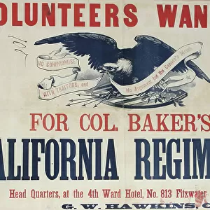
Mouse Mat : Map of the mining district of California, 1851. Creator: William A. Jackson


![]()
Home Decor from Heritage Images
Map of the mining district of California, 1851. Creator: William A. Jackson
Map of the mining district of California, 1851. This map, produced in two parts in the early years after the California Gold Rush of 1849, shows the regions where gold was discovered in the territory. Accompanying the map was a 16-page appendix that gave further information on the location and significance of the gold strikes. The discovery of gold at Sutter's Mill on the American River in January 1848 attracted migrants from the east coast of the United States, as well as from Europe, Central and South America, Australia, and Asia. The Treaty of Guadalupe Hidalgo ending the Mexican-American War, signed within two weeks of the discovery at Sutter's Mill, made California a U.S. territory after centuries of control by Spain and Mexico. The influx of some 300, 000 people accelerated the pace of political change in the territory. Captain William A. Jackson, the cartographer, was an engineer who had personal experience of the mines. The map and appendix shown here were published in 1851 and are revised from the first edition produced in 1850. Accompanied by: Appendix to Jackson's map of the mining districts of California. 16 p ; 15 cm. LC Trails
Heritage Images features heritage image collections
Media ID 35128045
© Heritage Art/Heritage Images
1850s California California United States Of America Californian Cartographic Cartography District Gold Rush Jackson Map Making Mapmaking Mariposa Migrating Migration Mine Mineral Mines Mining Pacific Coast Territorial Territory Valley William A American River Compass Rose Meeting Of Frontiers Napa Valley Sacramento Valley West Coast
Mouse Mat
A high quality photographic print manufactured into a durable wipe clean mouse mat (27x22cm) with a non slip backing, which works with all mice.
Archive quality photographic print in a durable wipe clean mouse mat with non slip backing. Works with all computer mice
Estimated Image Size (if not cropped) is 20.8cm x 25.4cm (8.2" x 10")
Estimated Product Size is 21.8cm x 26.9cm (8.6" x 10.6")
These are individually made so all sizes are approximate
Artwork printed orientated as per the preview above, with portrait (vertical) orientation to match the source image.
FEATURES IN THESE COLLECTIONS
> Animals
> Mammals
> Cricetidae
> California Mouse
> Arts
> Artists
> P
> William Page
> Arts
> Landscape paintings
> Waterfall and river artworks
> River artworks
> Europe
> Spain
> Related Images
> Historic
> Colonial America illustrations
> Colonial America
EDITORS COMMENTS
This map, created by engineer and cartographer Captain William A. Jackson in 1851, offers a glimpse into the early days of the California Gold Rush. The map, divided into two parts, meticulously illustrates the regions in California where gold was discovered following the pivotal discovery at Sutter's Mill on the American River in January 1848. The influx of over 300,000 people from the United States and abroad, as well as from Europe, Central and South America, Australia, and Asia, was accelerated by the Treaty of Guadalupe Hidalgo, which made California a U.S. territory after centuries of Spanish and Mexican rule. Captain Jackson, with firsthand knowledge of the mines, produced this map along with an accompanying 16-page appendix. The appendix provided valuable information on the location and significance of the gold strikes, making it an essential resource for the thousands of prospectors seeking their fortune in the new territory. This map and appendix, published in 1851, represent a crucial moment in California's history as it transitioned from a Spanish and Mexican colony to an American territory. The detailed and accurate representation of the mining districts in this map serves as a testament to Captain Jackson's expertise and the significance of the California Gold Rush in shaping the history of the United States.
MADE IN THE UK
Safe Shipping with 30 Day Money Back Guarantee
FREE PERSONALISATION*
We are proud to offer a range of customisation features including Personalised Captions, Color Filters and Picture Zoom Tools
SECURE PAYMENTS
We happily accept a wide range of payment options so you can pay for the things you need in the way that is most convenient for you
* Options may vary by product and licensing agreement. Zoomed Pictures can be adjusted in the Basket.