Mouse Mat > Arts > Minimalist artwork > Monochrome artwork > Fine art
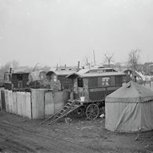
Mouse Mat : Chart of the West Indies, with the adjacent Coast of South America, 1830. Artist: J&C Walker


![]()
Home Decor from Heritage Images
Chart of the West Indies, with the adjacent Coast of South America, 1830. Artist: J&C Walker
Chart of the West Indies, with the adjacent Coast of South America, 1830. Map of the Caribbean, showing the tracks of Christopher Columbus
Heritage Images features heritage image collections
Media ID 14943908
© The Print Collector / Heritage-Images
Caribbean Cartography Discovery Exploration Explorer Genoese Indies Island Journey Map Making Route Voyage Walker West Indies Print Collector8
Mouse Mat
A high quality photographic print manufactured into a durable wipe clean mouse mat (27x22cm) with a non slip backing, which works with all mice.
Archive quality photographic print in a durable wipe clean mouse mat with non slip backing. Works with all computer mice
Estimated Image Size (if not cropped) is 25.4cm x 18.2cm (10" x 7.2")
Estimated Product Size is 26.9cm x 21.8cm (10.6" x 8.6")
These are individually made so all sizes are approximate
Artwork printed orientated as per the preview above, with landscape (horizontal) orientation to match the source image.
FEATURES IN THESE COLLECTIONS
> Arts
> Minimalist artwork
> Monochrome artwork
> Fine art
> Arts
> Minimalist artwork
> Monochrome artwork
> Monochrome paintings
> Europe
> Italy
> Related Images
> Europe
> Spain
> Related Images
> Maps and Charts
> Italy
EDITORS COMMENTS
This print, titled "Chart of the West Indies, with the adjacent Coast of South America, 1830" takes us on a visual journey back in time. Created by J&C Walker, renowned cartographers of the 19th century, this intricate map showcases the exploration and discovery that shaped our understanding of the Caribbean and South America. The artist's attention to detail is evident as we explore this monochrome engraving. The chart depicts not only the coastlines but also highlights important geographical features such as islands and routes taken by Christopher Columbus during his historic voyages. It serves as a testament to the significant role played by Italian explorer Columbus in uncovering new lands for Spain. As we gaze upon this piece, it transports us to an era when travel was filled with uncertainty and excitement. We can almost imagine ourselves sailing alongside these brave explorers as they ventured into uncharted territories. The map's historical significance lies not only in its depiction of physical landscapes but also in its representation of cultural exchange between Europe and the Americas. It reminds us of how exploration led to colonization and forever changed both continents' destinies. This print from Heritage Images offers a glimpse into centuries past while showcasing J&C Walker's mastery in map-making. It invites us to appreciate not only their artistic skill but also their contribution to our knowledge of world geography.
MADE IN THE UK
Safe Shipping with 30 Day Money Back Guarantee
FREE PERSONALISATION*
We are proud to offer a range of customisation features including Personalised Captions, Color Filters and Picture Zoom Tools
SECURE PAYMENTS
We happily accept a wide range of payment options so you can pay for the things you need in the way that is most convenient for you
* Options may vary by product and licensing agreement. Zoomed Pictures can be adjusted in the Basket.