Mouse Mat > Africa > Madagascar > Maps
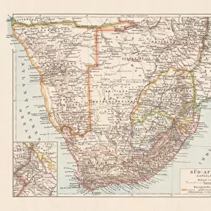
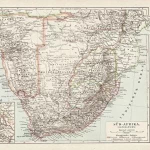
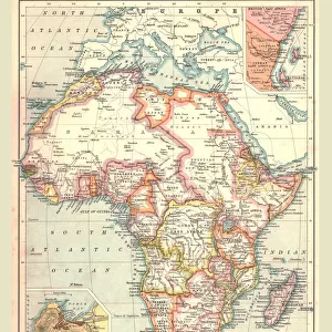
Mouse Mat : Antique map of Africa in the 19th Century, 1873


![]()
Home Decor from Fine Art Storehouse
Antique map of Africa in the 19th Century, 1873
Vintage engraving of a Victorian Antique map of Africa in the 19th Century, 1873
Unleash your creativity and transform your space into a visual masterpiece!
duncan1890
Media ID 13609255
© This content is subject to copyright
1870 1879 Aged Bad Condition Central Africa Colour Colours Condition Damaged East Africa Equipment Faded Image Created 1870 1879 Madagascar Navigational Equipment North Africa Retro Southern Africa Styles Supplies Victorian Obsolete Retro Styled Victorian Style
Mouse Mat
A high quality photographic print manufactured into a durable wipe clean mouse mat (27x22cm) with a non slip backing, which works with all mice.
Archive quality photographic print in a durable wipe clean mouse mat with non slip backing. Works with all computer mice
Estimated Image Size (if not cropped) is 21.8cm x 25.4cm (8.6" x 10")
Estimated Product Size is 21.8cm x 26.9cm (8.6" x 10.6")
These are individually made so all sizes are approximate
Artwork printed orientated as per the preview above, with portrait (vertical) orientation to match the source image.
FEATURES IN THESE COLLECTIONS
> Fine Art Storehouse
> Map
> Historical Maps
> Africa
> Madagascar
> Maps
> Africa
> Madagascar
> Related Images
> Africa
> Related Images
> Europe
> United Kingdom
> Maps
> Europe
> United Kingdom
> Paintings
> Historic
> Historical fashion trends
> Victorian fashion trends
> Historic
> Victorian era fashion
> Maps and Charts
> Related Images
EDITORS COMMENTS
This print showcases an antique map of Africa from the 19th century, specifically dating back to 1873. The vintage engraving captures the essence of Victorian cartography, despite its current bad condition. The image portrays a fascinating glimpse into the past, with intricate details and vibrant colors that were characteristic of that era. Although time has taken its toll on this piece, it still holds immense historical value. Its damaged state adds to its charm and serves as a reminder of the passage of time. From Central Africa to East Africa, North Africa to Southern Africa, every region is meticulously depicted on this aged map. The engraving skillfully illustrates navigational equipment used during that period and provides insight into how maps were created in those days. Madagascar also finds its place on this antiquated masterpiece. With a retro style reminiscent of old-fashioned illustrations and paintings, this vertical print transports us back in time. Its faded colors only enhance its nostalgic appeal while maintaining an archival quality. Duncan1890's work allows us to appreciate the beauty found within these forgotten relics from history. This print offers a unique opportunity for art enthusiasts and history buffs alike to own a piece that encapsulates both artistic styles and historical significance in one frame
MADE IN THE UK
Safe Shipping with 30 Day Money Back Guarantee
FREE PERSONALISATION*
We are proud to offer a range of customisation features including Personalised Captions, Color Filters and Picture Zoom Tools
SECURE PAYMENTS
We happily accept a wide range of payment options so you can pay for the things you need in the way that is most convenient for you
* Options may vary by product and licensing agreement. Zoomed Pictures can be adjusted in the Basket.