Mounted Print > Arts > Landscape paintings > Waterfall and river artworks > River artworks
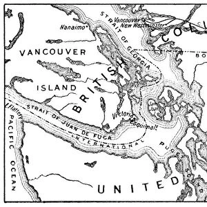
Mounted Print : CANADA: MAP, 1872. Map of the boundary between British and American territory on the Pacific coast, settled by the decision of the Emperor of Germany by arbitration in 1872, which gave the disputed San Juan Island to the United States. Wood engraving, American, 1872


![]()
Mounted Prints from Granger
CANADA: MAP, 1872. Map of the boundary between British and American territory on the Pacific coast, settled by the decision of the Emperor of Germany by arbitration in 1872, which gave the disputed San Juan Island to the United States. Wood engraving, American, 1872
Granger holds millions of images spanning more than 25,000 years of world history, from before the Stone Age to the dawn of the Space Age
Media ID 7540315
1872 Boundary British Empire Canada Canadian Coast Colonialism North West Pacific Northwest Territory San Juan Island
14"x12" Mount with 12"x10" Print
Step back in time with our vintage Map of Canada from 1872. This intricately detailed wood engraving, sourced from The Granger Collection, depicts the boundary between British and American territory on the Pacific coast. Witness the historical decision made by the Emperor of Germany through arbitration, which granted the disputed San Juan Island to the United States. Add this captivating piece of history to your home or office as a mounted photo, a conversation starter and a reminder of the past.
Printed on 12"x10" paper and suitable for use in a 14"x12" frame (frame not included). Prints are mounted with card both front and back. Featuring a custom cut aperture to match chosen image. Professional 234gsm Fujifilm Crystal Archive DP II paper.
Photo prints supplied in custom cut card mount ready for framing
Estimated Image Size (if not cropped) is 27.7cm x 25.4cm (10.9" x 10")
Estimated Product Size is 35.6cm x 30.5cm (14" x 12")
These are individually made so all sizes are approximate
Artwork printed orientated as per the preview above, with landscape (horizontal) orientation to match the source image.
FEATURES IN THESE COLLECTIONS
> Arts
> Landscape paintings
> Waterfall and river artworks
> River artworks
> Maps and Charts
> British Empire Maps
> Maps and Charts
> Related Images
> North America
> Canada
> Maps
> North America
> Canada
> Related Images
> North America
> Related Images
EDITORS COMMENTS
This historic print showcases a significant moment in the territorial disputes between Canada and the United States during the late 19th century. The wood engraving, created by an American artist in 1872, depicts a detailed map of the boundary between British and American territory on the Pacific coast. This boundary was settled through arbitration by the Emperor of Germany in that same year. The map highlights the disputed San Juan Island, which ultimately became part of the United States as per Germany's decision. The intricate details captured in this engraving allow us to visualize how colonial powers negotiated their claims over vast territories. The image serves as a reminder of both cooperation and conflict between nations during this era of expansionism. It symbolizes not only political maneuvering but also represents English influence within North America's northwest region. As we reflect upon this historical artifact from Granger Art on Demand, it is essential to acknowledge its significance beyond commercial use. This print invites us to explore complex themes such as colonialism, national boundaries, and diplomatic resolutions while appreciating its artistic value as a wood engraving from 1872.
MADE IN THE UK
Safe Shipping with 30 Day Money Back Guarantee
FREE PERSONALISATION*
We are proud to offer a range of customisation features including Personalised Captions, Color Filters and Picture Zoom Tools
SECURE PAYMENTS
We happily accept a wide range of payment options so you can pay for the things you need in the way that is most convenient for you
* Options may vary by product and licensing agreement. Zoomed Pictures can be adjusted in the Basket.