Metal Print > Europe > France > Canton > Landes
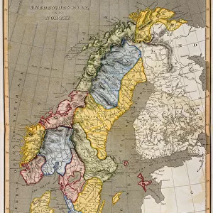
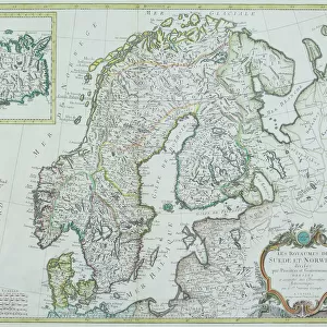
Metal Print : 1855, Colton Map of Scandinavia, Norway, Sweden, Finland, topography, cartography


![]()
Metal Prints from Liszt Collection
1855, Colton Map of Scandinavia, Norway, Sweden, Finland, topography, cartography
1855, Colton Map of Scandinavia, Norway, Sweden, Finland
Liszt Collection of nineteenth-century engravings and images to browse and enjoy
Media ID 14005495
© Artokoloro Quint Lox Limited
1855 Finland Norway Sweden Antique Map Latitude Longitude Mappa Mundi Old Antique Plan Old Antique View Ols Antique Map Rare Old Maps Topo
20"x16" (51x41cm) Metal Print
Discover the historic beauty of Scandinavia with our Media Storehouse Metal Print of the 1855 Colton Map. This exquisite piece showcases intricate topographical details of Norway, Sweden, and Finland, meticulously crafted by the renowned cartographer J.H. Colton. Hailing from the prestigious Liszt Collection, this vintage map transports you back in time, making it a perfect addition to your home or office decor. The high-quality Metal Print preserves the map's rich details and authentic colors, ensuring a stunning visual representation of Scandinavia's history. Elevate your space with this captivating piece of cartographic art.
Your image is printed photographically and bonded to a 3.5mm thick, Dibond board (black polyethylene sandwiched between two sheets of white coated aluminium). The panel is then sealed with a gloss protective covering. Supplied complete with a wall mount which holds the print 10mm from the wall.
Made with durable metal and luxurious printing techniques, metal prints bring images to life and add a modern touch to any space
Estimated Product Size is 40.6cm x 50.8cm (16" x 20")
These are individually made so all sizes are approximate
Artwork printed orientated as per the preview above, with landscape (horizontal) or portrait (vertical) orientation to match the source image.
FEATURES IN THESE COLLECTIONS
> Europe
> Finland
> Related Images
> Europe
> France
> Canton
> Landes
> Europe
> Norway
> Related Images
> Europe
> Sweden
> Related Images
EDITORS COMMENTS
This print showcases a remarkable piece of history - the 1855 Colton Map of Scandinavia, Norway, Sweden, and Finland. With its intricate topography and meticulous cartography, this map offers a fascinating glimpse into the geographical features and land formations of these Nordic countries during that era. The vintage charm of this ancient map is evident in its aged paper texture and retro artistic style. It serves as a testament to the artistry and skill involved in creating such detailed illustrations before the advent of modern technology. As you explore this historic treasure, you can't help but be transported back in time to an age when navigation relied on maps like these for exploration and discovery. The grid lines depicting latitude and longitude add a touch of geometric precision to the overall composition. This rare antique map not only provides valuable insights into Scandinavia's past but also serves as an intriguing decorative piece for any space. Its historical significance makes it a must-have for collectors or anyone with an appreciation for world history. Whether displayed in your home or office, this stunning print from Liszt Collection invites you to embark on a journey through time while admiring the beauty of our planet's diverse regions.
MADE IN THE UK
Safe Shipping with 30 Day Money Back Guarantee
FREE PERSONALISATION*
We are proud to offer a range of customisation features including Personalised Captions, Color Filters and Picture Zoom Tools
SECURE PAYMENTS
We happily accept a wide range of payment options so you can pay for the things you need in the way that is most convenient for you
* Options may vary by product and licensing agreement. Zoomed Pictures can be adjusted in the Basket.