Metal Print > Maps and Charts > World
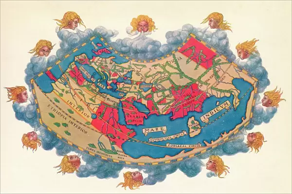
Metal Print : Ptolemys Map of the World cA. D 150. (1912) Artist: Claudius Ptolemy
 Artist: Claudius Ptolemy")


![]()
Metal Prints from Heritage Images
Ptolemys Map of the World cA. D 150. (1912) Artist: Claudius Ptolemy
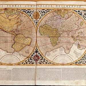
Ptolemys Map of the World cA.D 150. The Ptolemy world map is a map of the known world to Hellenistic society in the 2nd century AD. It was based on the description contained in Ptolemys book Geographia, written c150. Perhaps the most significant contributions of Ptolemys maps are the first uses of longitudinal and latitudinal lines. Taken from A Book of Discovery, published by T. C. & E. C. Jack Ltd. 1912
Heritage Images features heritage image collections
Media ID 14959354
© The Print Collector
2nd Century Blowing Cartography Claudius Claudius Of Ptolemaeus Claudius Ptolemy Hellenistic Jack Longitude Map Making Ptolemy Tc And Ec Tc And Ec Jack Wind World Map Latitude
15"x10" (38x25cm) Metal Print
Step back in time with our stunning Metal Print of Ptolemy's Map of the World, circa A.D 150. This captivating piece, featuring the renowned work of ancient Greek cartographer Claudius Ptolemy from Heritage Images, brings history to life. Discover the intricate details of the known world to Hellenistic society, as depicted in this iconic map. Elevate your space with this unique and thought-provoking addition to your decor.
Your image is printed photographically and bonded to a 3.5mm thick, Dibond board (black polyethylene sandwiched between two sheets of white coated aluminium). The panel is then sealed with a gloss protective covering. Supplied complete with a wall mount which holds the print 10mm from the wall.
Made with durable metal and luxurious printing techniques, metal prints bring images to life and add a modern touch to any space
Estimated Product Size is 38.1cm x 25.4cm (15" x 10")
These are individually made so all sizes are approximate
Artwork printed orientated as per the preview above, with landscape (horizontal) or portrait (vertical) orientation to match the source image.
FEATURES IN THESE COLLECTIONS
> Heritage Images
> Maps Charts & Plans
> Maps and Charts
> Related Images
> Maps and Charts
> World
EDITORS COMMENTS
This print showcases Ptolemy's Map of the World, created around AD 150. The artist behind this remarkable piece is none other than Claudius Ptolemy himself. This ancient map provides a glimpse into the known world during Hellenistic society in the 2nd century AD, as described in Ptolemy's book Geographia. What sets Ptolemy's maps apart are their pioneering use of longitudinal and latitudinal lines, which were groundbreaking for cartography at that time. These lines allowed for more accurate navigation and measurement of distances across vast territories. In this close-up shot, we see vibrant hues of blue and red dominating the scene. The wind seems to be blowing fiercely, adding an element of dynamism to the image. A lone male figure stands beside the map, perhaps contemplating its significance or marveling at its intricate details. Dating back over a millennium ago, this artifact serves as a testament to human curiosity and exploration throughout history. It represents an era when knowledge was painstakingly gathered through observation and meticulous documentation. Preserved within these weathered contours lies not just geographical information but also stories of civilizations long gone. This print from 1912 captures both the beauty and historical importance encapsulated within Ptolemy's Map of the World—a true treasure for any lover of art, history, or geography alike.
MADE IN THE UK
Safe Shipping with 30 Day Money Back Guarantee
FREE PERSONALISATION*
We are proud to offer a range of customisation features including Personalised Captions, Color Filters and Picture Zoom Tools
SECURE PAYMENTS
We happily accept a wide range of payment options so you can pay for the things you need in the way that is most convenient for you
* Options may vary by product and licensing agreement. Zoomed Pictures can be adjusted in the Basket.