Fraud Blocker Skip to main content

Ptolemy Collection

"Ptolemy: Unraveling the Mysteries of the Universe through Time" Step into the world of Ptolemy

Background imagePtolemy Collection: Johannes Keplers model of the universe. Line engraving from his Mysterium Cosmographicum, 1596

Johannes Keplers model of the universe. Line engraving from his Mysterium Cosmographicum, 1596
KEPLERs UNIVERSE, 1596. Johannes Keplers model of the universe. Line engraving from his Mysterium Cosmographicum, 1596

Background imagePtolemy Collection: Oronce Fines world map, 1531

Oronce Fines world map, 1531
Oronce Fines world map. Map of the worlds northern and southern hemispheres by the French mathematician and cartographer Oronce Fine (1494-1555)

Background imagePtolemy Collection: Ptolemys Map of the World cA. D 150. (1912) Artist: Claudius Ptolemy

Ptolemys Map of the World cA. D 150. (1912) Artist: Claudius Ptolemy
Ptolemys Map of the World cA.D 150. The Ptolemy world map is a map of the known world to Hellenistic society in the 2nd century AD

Background imagePtolemy Collection: Ptolemy & Cleopatra Wall

Ptolemy & Cleopatra Wall
Ptolemy and Cleopatra make offerings to divinities

Background imagePtolemy Collection: With the sun at the center; Copernicus appears at lower right and Ptolemy at lower left

With the sun at the center; Copernicus appears at lower right and Ptolemy at lower left
COPERNICAN UNIVERSE, 1660. With the sun at the center; Copernicus appears at lower right and Ptolemy at lower left. Copperplate engraving from Andreas Cellarius Atlas Coelestis seu Harmonia

Background imagePtolemy Collection: PTOLEMY, Claudius Ptolemaeus ( c. AD 100 - c

PTOLEMY, Claudius Ptolemaeus ( c. AD 100 - c
" PTOLEMY, Claudius Ptolemaeus ( c. AD 100 - c. AD 170). Egyptian astronomer, mathematician and geographer. Map of the Ancient World. From the work " Ptolomeus Geographicorum Libri"

Background imagePtolemy Collection: Northern hemisphere star chart, 1537

Northern hemisphere star chart, 1537
Northern hemisphere star chart, 16th century. Star chart (planisphere) of the northern hemisphere, based on Albrecht Durers star charts of 1515. The illustrations show the constellations

Background imagePtolemy Collection: World Known to Ptolemy

World Known to Ptolemy
1545 map from Basel, Switzerland, depicting the world as known to Ptolemy in the 2nd century

Background imagePtolemy Collection: PTOLEMYs SYSTEM (2)

PTOLEMYs SYSTEM (2)
Earth is depicted at the centre of the cosmos, circled by the seven planets known to him : our globe is made up of four elements - earth, air, fire and water

Background imagePtolemy Collection: PTOLEMYs SYSTEM (1)

PTOLEMYs SYSTEM (1)
A representation of his system, showing Earth at the centre of the cosmos, circled by the planets and by the signs of the Zodiac

Background imagePtolemy Collection: The School of Athens. (Fresco in Stanza della Segnatura), ca 1510-1511. Creator: Raphael

The School of Athens. (Fresco in Stanza della Segnatura), ca 1510-1511. Creator: Raphael
The School of Athens. (Fresco in Stanza della Segnatura), ca 1510-1511. Private Collection

Background imagePtolemy Collection: Library of Alexandria

Library of Alexandria
Ptolemy I Soter inaugurates the great library at Alexandria Date: circa 370 BC

Background imagePtolemy Collection: Ptolemy World map, 1467

Ptolemy World map, 1467. Found in the collection of Biblioteka Narodowa, Warszawa

Background imagePtolemy Collection: A diagram of the Universe by the 17th century English Neoplatonist Robert Fludd showing the links

A diagram of the Universe by the 17th century English Neoplatonist Robert Fludd showing the links between the hidden
FLUDDs UNIVERSE. A diagram of the Universe by the 17th century English Neoplatonist Robert Fludd showing the links between the hidden God and the manifest world

Background imagePtolemy Collection: EXPL2A-00014

EXPL2A-00014
Ptolemys map of the world, illustrating a concept of the flat earth. Hand-colored 19th-century woodcut reproduction

Background imagePtolemy Collection: with the sun at the center. Engraving, Dutch, 17th century

with the sun at the center. Engraving, Dutch, 17th century
COPERNICAN UNIVERSE with the sun at the center. Engraving, Dutch, 17th century

Background imagePtolemy Collection: Southern Hemisphere, by Carel Allard, Amsterdam

Southern Hemisphere, by Carel Allard, Amsterdam
CELESTIAL PLANISPHERE. Southern Hemisphere, by Carel Allard, Amsterdam

Background imagePtolemy Collection: COPERNICAN UNIVERSE, 1660. Copernican map of the Universe, with the sun at the center

COPERNICAN UNIVERSE, 1660. Copernican map of the Universe, with the sun at the center: copperplate engraving from Andreas Cellarius " Atlas Coelestis seu Harmonia Macrocosmica

Background imagePtolemy Collection: APIAN: WORLD MAP, 1530. Heart-shaped map of the world, with small portraits of Amerigo Vespucci

APIAN: WORLD MAP, 1530. Heart-shaped map of the world, with small portraits of Amerigo Vespucci (upper left) and Ptolemy (upper right) by Peter Apian, 1530

Background imagePtolemy Collection: Southern hemisphere star chart, 1537

Southern hemisphere star chart, 1537
Southern hemisphere star chart, 16th century. Star chart (planisphere) of the southern hemisphere, based on Albrecht Durers star charts of 1515. The illustrations show the constellations

Background imagePtolemy Collection: Urania, the Muse of Astronomy represented in front of Argus, holding a telescope

Urania, the Muse of Astronomy represented in front of Argus, holding a telescope
GIA4709988 Urania, the Muse of Astronomy represented in front of Argus, holding a telescope. They weigh and compare the system of Copernicus (left)

Background imagePtolemy Collection: World map by Claudius Ptolemy (90-168). Engraving, 16th cent

World map by Claudius Ptolemy (90-168). Engraving, 16th cent
Claudius Ptolemy (90-168) Greco-Egyptian geographer. World map. Engraving, 16th century

Background imagePtolemy Collection: Celestial Map of the Planets (coloured engraving)

Celestial Map of the Planets (coloured engraving)
BAL42828 Celestial Map of the Planets (coloured engraving) by Eimmart, Georg Christoph II (1638-1705); O Shea Gallery, London, UK; German, out of copyright

Background imagePtolemy Collection: PTOLEMY (2nd CENTURY A. D. ). Alexandrian astronomer, mathematician and geographer

PTOLEMY (2nd CENTURY A. D. ). Alexandrian astronomer, mathematician and geographer: colored line engraving, French
PTOLEMY (2nd CENTURY A.D.). Alexandrian astronomer, mathematician and geographer: colored line engraving, French, 1584

Background imagePtolemy Collection: PSCI2A-00097

PSCI2A-00097
Ptolemys earth-centered cosmological system, explained by Muller, 1400s. Hand-colored 19th century woodcut reproduction of the 1543 edition

Background imagePtolemy Collection: World Map 1587

World Map 1587
Mercators projection, with parallel latitudinals, mentioning recent navigations such as Magellan

Background imagePtolemy Collection: Map of Ptolemy published in 1482

Map of Ptolemy published in 1482
GIA4812936 Map of Ptolemy published in 1482. by Unknown Artist, (15th century); Pinacoteca di Brera, Milan, Italy; (add.info.: Map of Ptolemy published in 1482.); eGiancarlo Costa; out of copyright

Background imagePtolemy Collection: Claude Ptolemy (ca. 100 - ca. 170), Greek scholar and astronomer

Claude Ptolemy (ca. 100 - ca. 170), Greek scholar and astronomer
XEE4403713 Claude Ptolemy (ca. 100 - ca. 170), Greek scholar and astronomer, in the Alexandria Observatory (Egypt). Barcelona 1877

Background imagePtolemy Collection: PTOLEMAIC UNIVERSE, 1660. Depiction of the Ptolemaic universe with the earth at the center

PTOLEMAIC UNIVERSE, 1660. Depiction of the Ptolemaic universe with the earth at the center: engraving from Andreas Cellarius " Atlas Coelestis seu Harmonia Macrocosmica, " Amsterdam, 1660

Background imagePtolemy Collection: The constellation of Auriga

The constellation of Auriga
5307771 The constellation of Auriga.; (add.info.: Engraving depicting the modern constellation of Auriga which was among those listed by the astronomer Ptolemy)

Background imagePtolemy Collection: Page of the manuscript 'Tractatus de sphaera' by Johannes of Sacrobosco (1190 - 1250)

Page of the manuscript "Tractatus de sphaera" by Johannes of Sacrobosco (1190 - 1250)
GIA5036614 Page of the manuscript "Tractatus de sphaera" by Johannes of Sacrobosco (1190 - 1250), known as John of Halifax or John of Holywood, representing the system of Ptolemy

Background imagePtolemy Collection: World map of Claudius Ptolemaeus (Claude Ptolemee, 90-168 ap JC)

World map of Claudius Ptolemaeus (Claude Ptolemee, 90-168 ap JC), Greek astronomer and astrologer (in red)
NWI4852574 World map of Claudius Ptolemaeus (Claude Ptolemee, 90-168 ap JC), Greek astronomer and astrologer (in red), contrasted with the real positions of cities and countries (in black)

Background imagePtolemy Collection: Sciences: Ptolemee (Claudius Ptolemaeus, 90-168), geocentric model of the solar system explained

Sciences: Ptolemee (Claudius Ptolemaeus, 90-168), geocentric model of the solar system explained by Muller
NWI4948435 Sciences: Ptolemee (Claudius Ptolemaeus, 90-168), geocentric model of the solar system explained by Muller, 15th century

Background imagePtolemy Collection: An astronomical quadrant

An astronomical quadrant
3732400 An astronomical quadrant; (add.info.: Illustration of an astronomical quadrant, an instrument used to measure angles up to 90 degrees. Dated 18th Century.); Universal History Archive/UIG.

Background imagePtolemy Collection: Page from the first printed edition of Ptolemy Almagest

Page from the first printed edition of Ptolemy Almagest
5311875 Page from the first printed edition of Ptolemy Almagest; (add.info.: Page from the first printed edition of Ptolemy Almagest, Venice, 1515, a catalogue of stars)

Background imagePtolemy Collection: Allegory of astronomy representing an astrologer and Ptolemy studying the celestial sphere

Allegory of astronomy representing an astrologer and Ptolemy studying the celestial sphere, 1515 (engraving)
FGL5461979 Allegory of astronomy representing an astrologer and Ptolemy studying the celestial sphere, 1515 (engraving); (add.info.: engraving by E. Schon 1515.).

Background imagePtolemy Collection: Geographical map of Italy. Miniature from the 15th century, based on the manuscript 'Geographia'

Geographical map of Italy. Miniature from the 15th century, based on the manuscript 'Geographia' (Geography)
BEN5469694 Geographical map of Italy. Miniature from the 15th century, based on the manuscript 'Geographia' (Geography) by Claudius Ptolemaeus (Claudius Ptolemaeus, 90-168)

Background imagePtolemy Collection: Tapestry of the Astrolabes, c.1451-1500 (silk wool)

Tapestry of the Astrolabes, c.1451-1500 (silk wool)
CUL4938892 Tapestry of the Astrolabes, c.1451-1500 (silk wool); Museo de Santa Cruz, Toledo, Spain; (add.info.: Tapestry of the astrolabe)

Background imagePtolemy Collection: World map after Ptolemy, 1513 (coloured woodcut)

World map after Ptolemy, 1513 (coloured woodcut)
7339798 World map after Ptolemy, 1513 (coloured woodcut) by Unknown Artist, (16th century); 44x58 cm; National Maritime Museum, London, UK; (add.info.: Creator: unknown)

Background imagePtolemy Collection: Cosmographia (Geography) by Ptolemy, 1477 (book)

Cosmographia (Geography) by Ptolemy, 1477 (book)
7415661 Cosmographia (Geography) by Ptolemy, 1477 (book); Bibliotheque Nationale, Paris, France; (add.info.: Claude Ptolemy (c.90-168) Cosmographia (Geography) Printed by Dominicus de Lapis Bologna

Background imagePtolemy Collection: An astronomical quadrant

An astronomical quadrant
3740720 An astronomical quadrant; (add.info.: Illustration of an astronomical quadrant, an instrument used to measure angles up to 90 degrees. Dated 18th Century.); Universal History Archive/UIG.

Background imagePtolemy Collection: Early Geographers' idea of the world

Early Geographers' idea of the world
3522071 Early Geographers' idea of the world; (add.info.: Early Geographers' idea of the world. Dated 18th Century); Universal History Archive/UIG.

Background imagePtolemy Collection: Planisphere de Claude Ptolemee (Claudius Ptolemaeus, 100-170)

Planisphere de Claude Ptolemee (Claudius Ptolemaeus, 100-170) - Gravure extraite de "Atlas Coelestis seu Harmonia
AIS5331518 Planisphere de Claude Ptolemee (Claudius Ptolemaeus, 100-170) - Gravure extraite de "Atlas Coelestis seu Harmonia Macrocosmica" (1661), de Andreas Cellarius - CELLARIUS

Background imagePtolemy Collection: An engraving depicting an imaginative reconstruction of Ptolemy of Alexandria in his observatory

An engraving depicting an imaginative reconstruction of Ptolemy of Alexandria in his observatory. Claudius Ptolemy (d)
5311629 An engraving depicting an imaginative reconstruction of Ptolemy of Alexandria in his observatory. Claudius Ptolemy (d)

Background imagePtolemy Collection: World map of Claude Ptolemee (Claudius Ptolemaeus, 90-168) illustrating the flat earth

World map of Claude Ptolemee (Claudius Ptolemaeus, 90-168) illustrating the flat earth
NWI4846095 World map of Claude Ptolemee (Claudius Ptolemaeus, 90-168) illustrating the flat earth. Colourful engraving of the 19th century.; (add.info)

Background imagePtolemy Collection: Map by Claude Ptolemee (Claudius Ptolemaeus, 90-168) showing the flat land without the American

Map by Claude Ptolemee (Claudius Ptolemaeus, 90-168) showing the flat land without the American continent
NWI4846822 Map by Claude Ptolemee (Claudius Ptolemaeus, 90-168) showing the flat land without the American continent, north and south poles, around 150

Background imagePtolemy Collection: Compare representations of the different cosmological systems, 1671 (engraving)

Compare representations of the different cosmological systems, 1671 (engraving)
FAT4300500 Compare representations of the different cosmological systems, 1671 (engraving); (add.info.: Compare representations of the different cosmological systems: Ptolemee, Plato, Tycho de Brahe)

Background imagePtolemy Collection: Page from the first printed edition of Ptolemy Almagest

Page from the first printed edition of Ptolemy Almagest
5311874 Page from the first printed edition of Ptolemy Almagest; (add.info.: Page from the first printed edition of Ptolemy Almagest, Venice, 1515)


All Professionally Made to Order for Quick Shipping

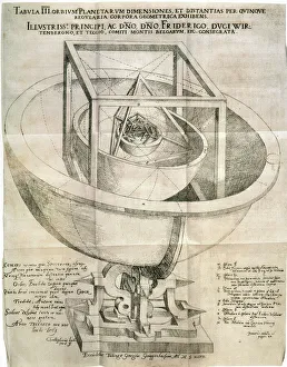
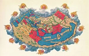
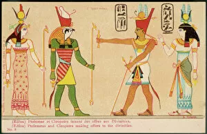
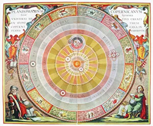
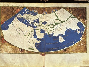
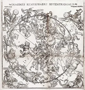
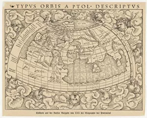
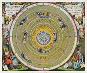
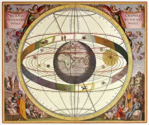
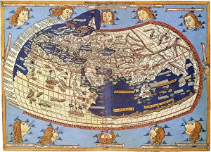
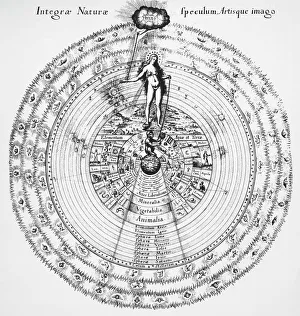
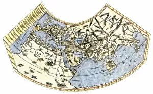
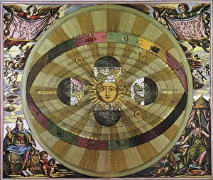
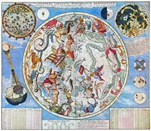
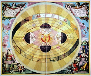
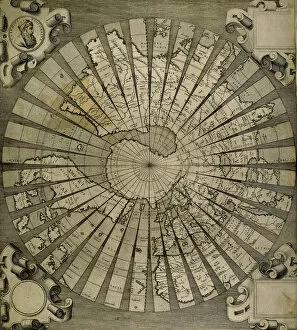
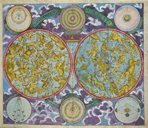
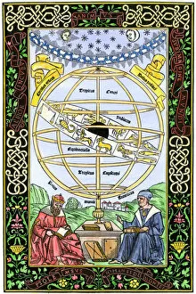
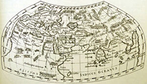
"Ptolemy: Unraveling the Mysteries of the Universe through Time" Step into the world of Ptolemy, a renowned ancient astronomer and geographer whose contributions shaped our understanding of the cosmos. From Johannes Kepler's model of the universe to Oronce Fine's intricate world map, Ptolemy's influence spans centuries. In Raphael's masterpiece "The School of Athens, " we catch a glimpse amidst esteemed philosophers, his ideas resonating with scholars even in 1510. His groundbreaking work is further showcased in Claudius Ptolemy's Map of the World from AD 150, an impressive testament to his cartographic skills. Marvel at Andreas Cellarius' copperplate engraving where Copernicus and Ptolemy stand side by side, representing two contrasting views on celestial motion. With the sun at its center, this depiction challenges Ptolemaic beliefs but acknowledges their historical significance. Delve deeper into Ptolemy's legacy as you explore Northern hemisphere star charts and discover worlds known to him during his time. Witness how he meticulously constructed his system that explained planetary movements with precision and elegance. But perhaps one cannot speak about Ptolemy without mentioning Cleopatra - their names forever intertwined in history. The grandeur of their reigns immortalized on walls that tell tales of power and love. Lastly, let us not forget the legendary Library of Alexandria - a beacon for knowledge seekers throughout antiquity. It was here that countless manuscripts were preserved, including works by none other than Claudius Ptolemaeus himself. Pioneering both astronomy and geography during an era when exploration was limited, Ptolemy left an indelible mark on scientific thought. As we gaze upon these artifacts from different eras, we are reminded that human curiosity knows no bounds – always seeking answers to unravel mysteries yet unknown.