Home > Maps and Charts > World
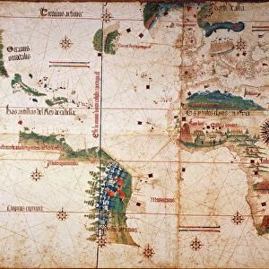
1755, Bellin Map of the Great Lakes, topography, cartography, geography, land, illustration

![]()
Wall Art and Photo Gifts from Liszt Collection
1755, Bellin Map of the Great Lakes, topography, cartography, geography, land, illustration
1755, Bellin Map of the Great Lakes
Liszt Collection of nineteenth-century engravings and images to browse and enjoy
Media ID 14006671
© Artokoloro Quint Lox Limited
1755 Antique Map Atlas Chart Geographic Latitude Longitude Mappa Mundi Old Antique Plan Old Antique View Old Map Ols Antique Map Rare Old Maps Topo
FEATURES IN THESE COLLECTIONS
> Maps and Charts
> Early Maps
> Maps and Charts
> World
EDITORS COMMENTS
This print showcases the 1755 Bellin Map of the Great Lakes, a true masterpiece in topography, cartography, and geography. With intricate details and precise measurements, this illustration offers a fascinating glimpse into the land formations of that era. Its vintage charm takes us back to ancient times when maps were meticulously hand-drawn on paper. The Bellin Map not only serves as a historical artifact but also as an artistic representation of our world's past. Its decorative elements and carefully crafted navigation tools make it a true work of art. As we explore its aged contours, we embark on a journey through time and space. This rare old map is more than just an antique; it holds immense value for those interested in history or geographical studies. Its depiction of latitude and longitude lines along with its geometric accuracy make it an invaluable resource for researchers and scholars alike. As we gaze upon this remarkable piece from the Liszt Collection, we are reminded of the importance of discovery and exploration throughout human history. The Great Lakes region comes alive before our eyes, reminding us of how far we have come in understanding our planet's vast landscapes. Whether you are an avid collector or simply appreciate the beauty found within historical artifacts, this print captures the essence of adventure and curiosity that lies within all explorers at heart.
MADE IN THE UK
Safe Shipping with 30 Day Money Back Guarantee
FREE PERSONALISATION*
We are proud to offer a range of customisation features including Personalised Captions, Color Filters and Picture Zoom Tools
SECURE PAYMENTS
We happily accept a wide range of payment options so you can pay for the things you need in the way that is most convenient for you
* Options may vary by product and licensing agreement. Zoomed Pictures can be adjusted in the Basket.