Home > North America > United States of America > Virginia > Chesapeake
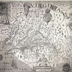
1630, Hondius Map of Virginia and the Chesapeake, topography, cartography, geography

![]()
Wall Art and Photo Gifts from Liszt Collection
1630, Hondius Map of Virginia and the Chesapeake, topography, cartography, geography
1630, Hondius Map of Virginia and the Chesapeake
Liszt Collection of nineteenth-century engravings and images to browse and enjoy
Media ID 14006552
© Artokoloro Quint Lox Limited
1630 Antique Map Atlas Chart Geographic Latitude Longitude Mappa Mundi Old Antique Plan Old Antique View Old Map Ols Antique Map Rare Old Maps Topo
FEATURES IN THESE COLLECTIONS
> Maps and Charts
> Early Maps
> Maps and Charts
> World
> North America
> United States of America
> Virginia
> Chesapeake
EDITORS COMMENTS
This print showcases the exquisite beauty and historical significance of the 1630 Hondius Map of Virginia and the Chesapeake. With its intricate topography, meticulous cartography, and detailed geography, this map offers a fascinating glimpse into the past. The land is meticulously illustrated with precision, capturing every contour and feature of this region. The grid lines denote latitude and longitude, adding a geometric element to this artistic masterpiece. As an ancient artifact from history's pages, it takes us back in time to explore the world as it was known then. Printed on vintage paper, this old map exudes a sense of nostalgia that transports us to bygone eras. Its decorative elements add charm and character while evoking a sense of adventure and discovery. This rare piece serves as both an educational tool for understanding our planet's evolution over time and a stunning work of art. As we gaze upon this historic treasure, we can't help but imagine early explorers embarking on their journeys through uncharted territories. It reminds us of humanity's insatiable thirst for knowledge about our surroundings—a desire that has driven exploration throughout history. Whether you are a lover of antique maps or simply appreciate the beauty found in historical artifacts, this print is sure to captivate your imagination. Let it transport you back in time as you marvel at the rich tapestry woven by centuries-old cartographers who sought to understand our world better.
MADE IN THE UK
Safe Shipping with 30 Day Money Back Guarantee
FREE PERSONALISATION*
We are proud to offer a range of customisation features including Personalised Captions, Color Filters and Picture Zoom Tools
SECURE PAYMENTS
We happily accept a wide range of payment options so you can pay for the things you need in the way that is most convenient for you
* Options may vary by product and licensing agreement. Zoomed Pictures can be adjusted in the Basket.