Jigsaw Puzzle > Europe > France > Canton > Landes
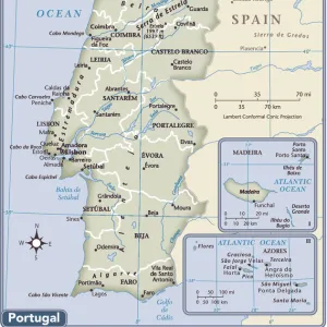
Jigsaw Puzzle : 1865 Spruner Map Of Spain And Portugal Topography


![]()
Jigsaw Puzzles from Universal Images Group (UIG)
1865 Spruner Map Of Spain And Portugal Topography
1865, Spruner Map of Spain and Portugal
Universal Images Group (UIG) manages distribution for many leading specialist agencies worldwide
Media ID 38551730
© Artokoloro Quint Lox Limited
1865 Antique Map Latitude Longitude Mappa Mundi Old Antique Plan Old Antique View Ols Antique Map Rare Old Maps Topo
Jigsaw Puzzle (500 Pieces)
"Unravel the rich history and geography of Spain and Portugal with our stunning jigsaw puzzle featuring a vintage map from 1865. This intricate piece, sourced from Universal Images Group (UIG), showcases the topography of the Iberian Peninsula in exquisite detail. With its unique blend of historical significance and visual appeal, this puzzle is perfect for anyone who loves geography, history, or simply a good challenge. Piece together the past and discover the beauty of Spain and Portugal like never before."
500 piece puzzles are custom made in the UK and hand-finished on 100% recycled 1.5 mm millboard. There is a level of repetition in jigsaw shapes with each matching piece away from its pair. The completed puzzle measures 38x50cm and is delivered packaged in an attractive presentation box specially designed to fit most letter box slots
Jigsaw Puzzles are an ideal gift for any occasion
Estimated Product Size is 50.2cm x 38cm (19.8" x 15")
These are individually made so all sizes are approximate
Artwork printed orientated as per the preview above, with landscape (horizontal) or portrait (vertical) orientation to match the source image.
FEATURES IN THESE COLLECTIONS
> Animals
> Fishes
> G
> Grouper
> Europe
> France
> Canton
> Landes
> Europe
> Portugal
> Related Images
> Historic
> Space exploration
> Maps and Charts
> Early Maps
> Maps and Charts
> Related Images
> Maps and Charts
> Spain
> Universal Images Group (UIG)
> History
> Historical Maps
EDITORS COMMENTS
Step back in time to the mid-19th century with this stunning 1865 Spruner Map of Spain and Portugal Topography. This beautifully illustrated map, courtesy of Universal Images Group (UIG), offers a fascinating glimpse into the geographical landscape of Iberia during a pivotal moment in history.
The intricate details on this vintage map reveal the region's mountain ranges, rivers, and coastal routes, providing insight into the topography that has shaped the cultures and civilizations that have flourished here. From the Pyrenees Mountains to the Atlantic coast, every contour line and geographic feature is meticulously rendered in exquisite detail.
This historic map not only serves as a valuable resource for cartographers and historians but also makes for a captivating piece of decorative art. Its aged appearance adds an air of nostalgia and romance, evoking memories of ancient explorers charting new territories.
Whether you're an enthusiast of geography, history, or simply appreciate beautiful illustrations, this 1865 Spruner Map of Spain and Portugal Topography is sure to captivate your imagination. Take a journey through time and discover the rich cultural heritage hidden within its borders.
MADE IN THE UK
Safe Shipping with 30 Day Money Back Guarantee
FREE PERSONALISATION*
We are proud to offer a range of customisation features including Personalised Captions, Color Filters and Picture Zoom Tools
SECURE PAYMENTS
We happily accept a wide range of payment options so you can pay for the things you need in the way that is most convenient for you
* Options may vary by product and licensing agreement. Zoomed Pictures can be adjusted in the Basket.