Jigsaw Puzzle > Europe > United Kingdom > England > London > Royalty
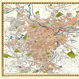
Jigsaw Puzzle : Old Map of Sheffield 1898 from the Royal Atlas by Bartholomew


![]()
Jigsaw Puzzles from MapSeeker
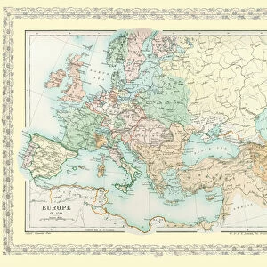
Old Map of Sheffield 1898 from the Royal Atlas by Bartholomew
A fine very detailed plan of the City of Sheffield remastered from an original contained within " The Royal Atlas of England and Wales" ; edited by J.G. Bartholomew, published by George Newnes, Limited, London
Welcome to the Mapseeker Image library and enter an historic gateway to one of the largest on-line collections of Historic Maps, Nostalgic Views, Vista's and Panorama's from a World gone by.
Media ID 20348024
Bartholomew Bartholomew Map Historic Map Old Town Plan Royal Atlas Royal Atlas Map Sheffield
Jigsaw Puzzle (400 Pieces)
Discover the rich history of Sheffield with our Old Map of Sheffield 1898 from the Royal Atlas by Bartholomew, now available as a captivating jigsaw puzzle from Media Storehouse. This intricately detailed puzzle, derived from the original map contained within "The Royal Atlas of England and Wales," offers an engaging and educational experience. Transport yourself back in time as you piece together the intricacies of Sheffield's urban landscape from over a century ago. The Old Map of Sheffield 1898 is not just a puzzle, but a journey through history. Bring the past to life in the comfort of your own home.
400 piece puzzles are custom made in the UK and hand-finished on 100% recycled 1.5 mm millboard. There is a level of repetition in jigsaw shapes with each matching piece away from its pair. The completed puzzle measures 31x47cm and is delivered packaged in an attractive presentation box specially designed to fit most letter box slots
Jigsaw Puzzles are an ideal gift for any occasion
Estimated Product Size is 47.2cm x 31.5cm (18.6" x 12.4")
These are individually made so all sizes are approximate
Artwork printed orientated as per the preview above, with landscape (horizontal) or portrait (vertical) orientation to match the source image.
FEATURES IN THESE COLLECTIONS
> Arts
> Photorealistic artworks
> Detailed art pieces
> Masterful detailing in art
> Europe
> United Kingdom
> England
> London
> Royalty
> Europe
> United Kingdom
> England
> Maps
> Europe
> United Kingdom
> England
> Sheffield
> Europe
> United Kingdom
> Wales
> Maps
> Europe
> United Kingdom
> Wales
> Posters
> Maps and Charts
> Related Images
> Maps and Charts
> Wales
> MapSeeker
> British Town And City Plans
> English & Welsh PORTFOLIO
EDITORS COMMENTS
Step back in time with this exquisite print of the 'Old Map of Sheffield 1898' from the renowned Royal Atlas by Bartholomew. This fine and highly detailed plan offers a captivating glimpse into the city's rich history, meticulously remastered from an original contained within 'The Royal Atlas of England and Wales. ' Published by George Newnes, Limited in London, this old map showcases the charming town plan of Sheffield as it stood over a century ago. Every intricate detail has been faithfully preserved, allowing you to explore the streets and landmarks that shaped this vibrant city. Immerse yourself in nostalgia as you trace your finger along its winding roads, revealing long-lost neighborhoods and forgotten corners. From bustling market squares to grand architectural marvels, each element on this historic map tells a story waiting to be discovered. Whether you are a seasoned historian or simply captivated by Sheffield's past, this print is sure to ignite your imagination. Hang it proudly on your wall or gift it to someone who shares your passion for heritage and cartography
MADE IN THE UK
Safe Shipping with 30 Day Money Back Guarantee
FREE PERSONALISATION*
We are proud to offer a range of customisation features including Personalised Captions, Color Filters and Picture Zoom Tools
SECURE PAYMENTS
We happily accept a wide range of payment options so you can pay for the things you need in the way that is most convenient for you
* Options may vary by product and licensing agreement. Zoomed Pictures can be adjusted in the Basket.