Home > Arts > Artists > H > Jodocus Hondius
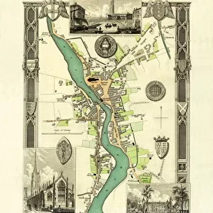
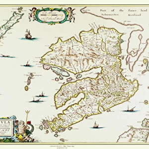
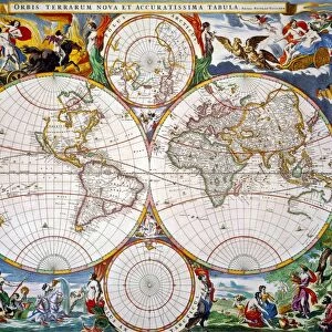
Old County Map of Cambridgeshire 1648 by Johan Blaeu from the Atlas Novus

![]()
Wall Art and Photo Gifts from MapSeeker
Old County Map of Cambridgeshire 1648 by Johan Blaeu from the Atlas Novus
This detailed and most attractive reproduction map of Cambridgeshire has been carefully art worked from a scan of an antique original. The famous firm of Dutch cartographers and publishers was established in the late 16th century by Willem Janszoon Blaeu in Amsterdam. Blaeu was a maker of globes and scientific instruments and purchased some of his early map plates from Jodocus Hondius. From this small beginning was to emerge one of the largest and most prolific map publishing houses of the seventeenth century
Welcome to the Mapseeker Image library and enter an historic gateway to one of the largest on-line collections of Historic Maps, Nostalgic Views, Vista's and Panorama's from a World gone by.
Media ID 20348146
Blaeu Blaeu Family County Map County Map Of England English County Map Historic Map Johan Blaeu Johan Blaeu Map Old Blaue Map Old County Map Old English County Map Cambridgeshire
FEATURES IN THESE COLLECTIONS
> Arts
> Artists
> B
> Willem Blaeu
> Arts
> Artists
> H
> Jodocus Hondius
> Arts
> Photorealistic artworks
> Detailed art pieces
> Masterful detailing in art
> Europe
> United Kingdom
> England
> Cambridgeshire
> Related Images
> Europe
> United Kingdom
> England
> Maps
> Maps and Charts
> Early Maps
> Maps and Charts
> Willem Janszoon Blaeu
> MapSeeker
> Maps from the British Isles
> England and Counties PORTFOLIO
EDITORS COMMENTS
This beautifully crafted reproduction of the "Old County Map of Cambridgeshire 1648" by Johan Blaeu takes us back in time to explore the rich history and intricate details of this English county. Carefully art worked from a scan of an antique original, this map captures the essence of Cambridgeshire as it was over three centuries ago. Johan Blaeu, a renowned Dutch cartographer and publisher, established his firm in Amsterdam during the late 16th century. Originally a maker of globes and scientific instruments, Blaeu's passion for maps led him to purchase map plates from Jodocus Hondius. Little did he know that this small beginning would pave the way for one of the largest and most prolific map publishing houses of the seventeenth century. The Blaeu family's dedication to cartography is evident in every detail of this historic piece. From its elegant design to its accurate depiction of towns, rivers, and landmarks, this map offers a glimpse into Cambridgeshire's past like never before. Whether you are an avid historian or simply fascinated by old maps, this print will transport you back in time. Discover how Cambridgeshire has evolved throughout centuries while marveling at Johan Blaeu's exceptional craftsmanship. Perfect for display in your home or office, this Old County Map serves as both a decorative piece and an educational tool. Immerse yourself in the historical charm it exudes and let your imagination wander through ancient streets and landscapes
MADE IN THE UK
Safe Shipping with 30 Day Money Back Guarantee
FREE PERSONALISATION*
We are proud to offer a range of customisation features including Personalised Captions, Color Filters and Picture Zoom Tools
SECURE PAYMENTS
We happily accept a wide range of payment options so you can pay for the things you need in the way that is most convenient for you
* Options may vary by product and licensing agreement. Zoomed Pictures can be adjusted in the Basket.