Jigsaw Puzzle > Arts > Photorealistic artworks > Detailed art pieces > Masterful detailing in art
Jigsaw Puzzle : General Map of Kharkiv Province: Showing Postal and Major Roads, Stations and the... 1821. Creators: Vasilii Petrovich Piadyshev, Iwanoff


![]()
Jigsaw Puzzles from Heritage Images
General Map of Kharkiv Province: Showing Postal and Major Roads, Stations and the... 1821. Creators: Vasilii Petrovich Piadyshev, Iwanoff
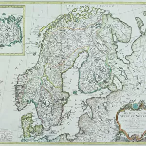
General Map of Kharkiv Province: Showing Postal and Major Roads, Stations and the Distance in Versts between Them, 1821. This 1821 map of Kharkiv Provinceis from a larger work, Geograficheskii atlas Rossiiskoi imperii, tsarstva Pol'skogo i velikogo kniazhestva Finliandskogo(Geographical atlas of the Russian Empire, the Kingdom of Poland, and the Grand Duchy of Finland), containing 60 maps of the Russian Empire. Compiled and engraved by Colonel V.P. Piadyshev, it reflects the detailed mapping carried out by Russian military cartographers in the first quarter of the 19th century. The map shows population centers (seven gradations by size), postal stations, roads (four types), state, provincial and district borders, factories, monasteries, and forts. Distances are shown in versts, a Russian measure, now no longer used, equal to 1.07 kilometers.Legends and place-names are in Russian and French
Heritage Images features heritage image collections
Media ID 35129061
© Heritage Art/Heritage Images
1820s Border Borders Cartographer Cartographic Cartography Communication Cyrillic Factories Fort Forts Iwanoff Legend Legendary Map Making Mapmaker Mapmaking Military Topographical Depot Monasteries Monastery Piadyshev Vasilii Petrovich Postal Station Roads Russian Empire Russian Federation Siberia Russia Thoroughfare Vasilii Petrovich Piadyshev Vp Piadyshev Fortifications Meeting Of Frontiers Postal Service
Jigsaw Puzzle (500 Pieces)
Discover the historical charm of the past with our exquisite jigsaw puzzle from Media Storehouse. This intricately detailed puzzle features a captivating General Map of Kharkiv Province, dating back to 1821. Created by renowned cartographers Vasilii Petrovich Piadyshev and Iwanoff, this map showcases the province's postal and major roads, stations, and the distances between them. Travel back in time as you piece together this beautiful puzzle, revealing the intricate network of transportation in Kharkiv Province during the early 19th century. A perfect addition to any home or office, this puzzle is not only a fun and engaging activity but also a beautiful conversation starter. Immerse yourself in history with Media Storehouse's General Map of Kharkiv Province jigsaw puzzle.
500 piece puzzles are custom made in the UK and hand-finished on 100% recycled 1.5 mm millboard. There is a level of repetition in jigsaw shapes with each matching piece away from its pair. The completed puzzle measures 38x50cm and is delivered packaged in an attractive presentation box specially designed to fit most letter box slots
Jigsaw Puzzles are an ideal gift for any occasion
Estimated Product Size is 50.2cm x 38cm (19.8" x 15")
These are individually made so all sizes are approximate
Artwork printed orientated as per the preview above, with landscape (horizontal) or portrait (vertical) orientation to match the source image.
FEATURES IN THESE COLLECTIONS
> Arts
> Photorealistic artworks
> Detailed art pieces
> Masterful detailing in art
> Europe
> Finland
> Related Images
> Europe
> Poland
> Related Images
EDITORS COMMENTS
This historic map print, titled "General Map of Kharkiv Province: Showing Postal and Major Roads, Stations and the Distance in Versts between Them," dates back to 1821. It is an extract from the larger work, "Geograficheskii atlas Rossiiskoi imperii, tsarstva Pol'skogo i velikogo kniazhestva Finliandskogo" (Geographical atlas of the Russian Empire, the Kingdom of Poland, and the Grand Duchy of Finland), which contained sixty maps of the Russian Empire. The map was compiled and engraved by Colonel Vasilii Petrovich Piadyshev and Iwanoff. The meticulously detailed map of Kharkiv Province showcases population centers, graded by size, postal stations, roads of various types, state, provincial, and district borders, factories, monasteries, and forts. Distances are indicated in versts, a Russian measurement now obsolete, equivalent to approximately 1.07 kilometers. This map is a testament to the extensive mapping efforts carried out by Russian military cartographers during the first quarter of the 19th century. The map's legends and place-names are in both Russian and French, reflecting the multinational character of the Russian Empire at the time. The map offers a fascinating glimpse into the geography and infrastructure of Kharkiv Province during the early 19th century, providing valuable context for historical research and scholarly pursuits. Its intricate details and rich historical significance make it an essential addition to any collection focused on Russian cartography, history, or geography.
MADE IN THE UK
Safe Shipping with 30 Day Money Back Guarantee
FREE PERSONALISATION*
We are proud to offer a range of customisation features including Personalised Captions, Color Filters and Picture Zoom Tools
SECURE PAYMENTS
We happily accept a wide range of payment options so you can pay for the things you need in the way that is most convenient for you
* Options may vary by product and licensing agreement. Zoomed Pictures can be adjusted in the Basket.