Greetings Card > Europe > France > Canton > Landes
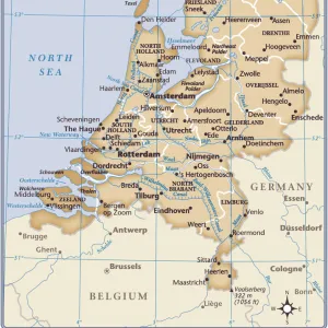
Greetings Card : 1748 Homann Heirs Map Of Holland Netherlands


![]()
Cards From Universal Images Group (UIG)
1748 Homann Heirs Map Of Holland Netherlands
1748, Homann Heirs Map of Holland, Netherlands
Universal Images Group (UIG) manages distribution for many leading specialist agencies worldwide
Media ID 38547965
© Artokoloro Quint Lox Limited
1748 Netherlands Antique Map Latitude Longitude Mappa Mundi Old Antique Plan Old Antique View Ols Antique Map Rare Old Maps Topo
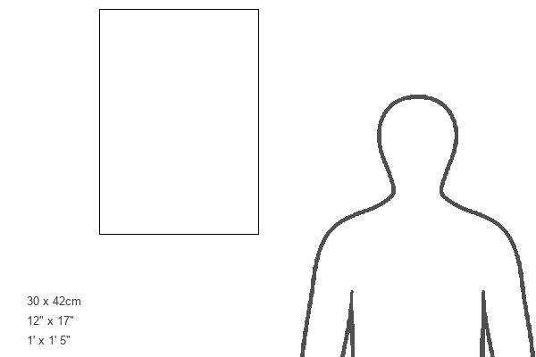
Greetings Card Large (A4)
"Add a touch of history to your greetings with our unique range of cards featuring iconic maps from the Media Storehouse collection. This stunning 1748 Homann Heirs Map of Holland, Netherlands is a beautiful representation of the region's rich heritage. Perfect for sending to friends and family who love history, travel, or simply appreciate the beauty of vintage cartography. Each card is carefully crafted with high-quality paper and printing to ensure a premium finish."
Create your own large greetings card. Size when folded is A4 (21x30cm or 8.3x11.7 inches)
Greetings Cards suitable for Birthdays, Weddings, Anniversaries, Graduations, Thank You and much more
Estimated Image Size (if not cropped) is 29.7cm x 21cm (11.7" x 8.3")
Estimated Product Size is 29.7cm x 42cm (11.7" x 16.5")
These are individually made so all sizes are approximate
Artwork printed orientated as per the preview above, with landscape (horizontal) orientation to match the source image.
FEATURES IN THESE COLLECTIONS
> Animals
> Fishes
> G
> Grouper
> Europe
> France
> Canton
> Landes
> Europe
> Netherlands
> Maps
> Europe
> Netherlands
> Related Images
> Historic
> Space exploration
> Maps and Charts
> Early Maps
> Maps and Charts
> Netherlands
> Maps and Charts
> Related Images
> Maps and Charts
> World
> Universal Images Group (UIG)
> History
> Historical Maps
EDITORS COMMENTS
Step back in time and explore the charming landscape of Holland, Netherlands as depicted on this stunning 1748 Homann Heirs map. This beautifully illustrated print showcases the region's intricate topography, highlighting its winding rivers, canals, and rolling hills. The meticulous attention to detail is a testament to the cartographic skills of Johann Baptist Homann's heirs, who carefully crafted this map over two centuries ago.
As you gaze upon this vintage treasure, imagine the journeys that took place along these waterways and roads. Merchants and travelers navigated these routes, carrying goods and stories from far-flung lands. The map's geometric grid provides a sense of order amidst the natural beauty of the Dutch countryside.
This antique print is not only a work of art but also a window into history. It offers a glimpse into the lives of those who lived in Holland during an era when trade and exploration were shaping the world we know today. Whether you're an historian, geography enthusiast, or simply someone with an appreciation for vintage aesthetics, this beautiful map is sure to captivate your imagination.
MADE IN THE UK
Safe Shipping with 30 Day Money Back Guarantee
FREE PERSONALISATION*
We are proud to offer a range of customisation features including Personalised Captions, Color Filters and Picture Zoom Tools
SECURE PAYMENTS
We happily accept a wide range of payment options so you can pay for the things you need in the way that is most convenient for you
* Options may vary by product and licensing agreement. Zoomed Pictures can be adjusted in the Basket.