Greetings Card > Arts > Artists > M > Gerardus Mercator
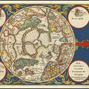
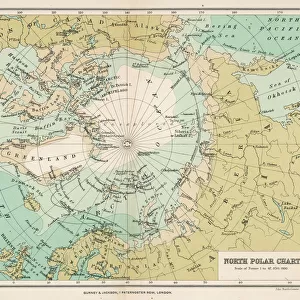
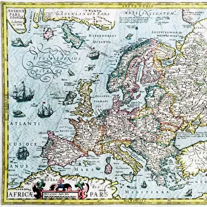
Greetings Card : Septentrionalium Terrarum descriptio, 1595, by Gerardus Merc


![]()
Cards from Mary Evans Picture Library
Septentrionalium Terrarum descriptio, 1595, by Gerardus Merc
Gerardus Mercator (1512-1594). Flemish cartographer. Septentrionalium Terrarum descriptio. Map of the Arctic with the North Pole and surrounding lands within and outside the Arctic Circle, 1595
Mary Evans Picture Library makes available wonderful images created for people to enjoy over the centuries
Media ID 14330268
© Thaliastock / Mary Evans
1595 Arctic Area Carthography Cartographer Cartography Circle Descriptio Earth Flanders Flemish Gerard Gerardus Globe Kremer Latin Letter Letters Mathematician Mercator Netherlands Philosopher Philosophy Pole Surrounding Terrarum Terrestrial
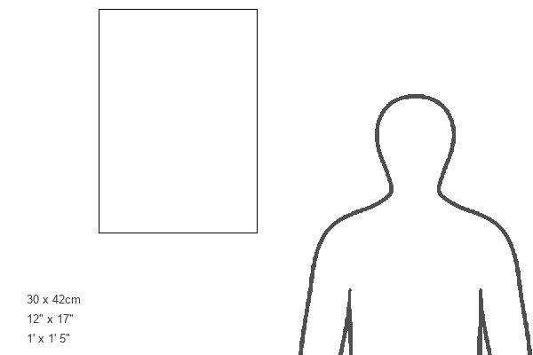
Greetings Card Large (A4)
Introducing the captivating range of greeting cards from Media Storehouse, featuring the exquisite "Septentrionalium Terrarum descriptio" map by Gerardus Mercator. Dated back to 1595, this enchanting image showcases the intricate details of the Arctic region, complete with the North Pole and surrounding lands within and outside the Arctic Circle. This stunning piece of cartography, sourced from Mary Evans Prints Online, is now transformed into unique and thoughtful greeting cards. Travel back in time and ignite the spirit of exploration with each card from this captivating collection. Perfect for birthdays, anniversaries, or simply to brighten someone's day, these one-of-a-kind cards are sure to leave an unforgettable impression.
Create your own large greetings card. Size when folded is A4 (21x30cm or 8.3x11.7 inches)
Greetings Cards suitable for Birthdays, Weddings, Anniversaries, Graduations, Thank You and much more
Estimated Image Size (if not cropped) is 29.7cm x 21cm (11.7" x 8.3")
Estimated Product Size is 29.7cm x 42cm (11.7" x 16.5")
These are individually made so all sizes are approximate
Artwork printed orientated as per the preview above, with landscape (horizontal) orientation to match the source image.
FEATURES IN THESE COLLECTIONS
> Arts
> Artists
> M
> Gerardus Mercator
> Europe
> France
> Canton
> Landes
> Europe
> Netherlands
> Maps
> Europe
> Netherlands
> Posters
> Europe
> Netherlands
> Related Images
> Europe
> Related Images
> Maps and Charts
> Early Maps
> Maps and Charts
> Gerardus Mercator's Cartographic
> Maps and Charts
> Netherlands
> Maps and Charts
> Related Images
Septentrionalium Terrarum Descriptio,
EDITORS COMMENTS
a captivating masterpiece created by the renowned Flemish cartographer Gerardus Mercator in 1595, offers a glimpse into the intriguing world of Arctic exploration during the late 16th century. This meticulously crafted map, also known as "Description of the Northern Lands," provides a detailed representation of the Arctic region and the lands situated within and beyond the Arctic Circle. Mercator, a mathematician, philosopher, and cartographer, was a pioneer in the modern age of cartography. His expertise in mapmaking was unparalleled, and his works significantly advanced the understanding of the terrestrial world during the European Renaissance. This engraving, produced in Flanders, showcases Mercator's unwavering dedication to accurate geographical representation. The map's central focus is the Arctic Circle, with the North Pole at its heart. The intricate detailing of the surrounding seas, including the Greenland Sea, the Norwegian Sea, and the Arctic Ocean, reveals the extensive knowledge Mercator had acquired through various sources, such as explorers' accounts and previous maps. The map also features the lettered labels identifying various lands, islands, and waterways, providing valuable context for the viewer. Septentrionalium Terrarum Descriptio serves as a testament to Mercator's unwavering curiosity and commitment to expanding human knowledge of the world. This map not only represents a significant contribution to the history of cartography but also offers a fascinating glimpse into the European exploration of the Arctic during the late 16th century.
MADE IN THE UK
Safe Shipping with 30 Day Money Back Guarantee
FREE PERSONALISATION*
We are proud to offer a range of customisation features including Personalised Captions, Color Filters and Picture Zoom Tools
SECURE PAYMENTS
We happily accept a wide range of payment options so you can pay for the things you need in the way that is most convenient for you
* Options may vary by product and licensing agreement. Zoomed Pictures can be adjusted in the Basket.