Glass Place Mat > North Wind Picture Archives > Exploration
Glass Place Mat : EXPL2A-00058


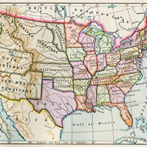
![]()
Home Decor from North Wind
EXPL2A-00058
Samuel de Champlains map of the Gaspee and Gulf of the Saint Lawrence River, 1632.
Hand-colored woodcut reproduction of the original map
North Wind Picture Archives brings history to life with stock images and hand-colored illustrations
Media ID 5879514
© North Wind Picture Archives
1600s 17th Century Adventure Atlantic Canada Canadian Cartography Champlain Chart Compass Discover Exploration Explore French French Canada Gaspee Maritime Navigation New France New World Newfoundland Ocean Quebec River Sailing Ship Samuel De Champlain Ship Travel Whale 1632 Calipers
Glass Place Mat (Set of 4)
Set of 4 Glass Place Mats. Stylish and elegant polished safety glass, toughened and heat resistant (275x225mm, 7mm thick). Matching Coasters also available.
Set of 4 Glass Place Mats. Elegant polished safety glass and heat resistant. Matching Coasters may also be available
Estimated Image Size (if not cropped) is 25.4cm x 20.4cm (10" x 8")
Estimated Product Size is 27.5cm x 22.5cm (10.8" x 8.9")
These are individually made so all sizes are approximate
FEATURES IN THESE COLLECTIONS
> North Wind Picture Archives
> Canadian history
> North Wind Picture Archives
> Exploration
> North Wind Picture Archives
> Maps
EDITORS COMMENTS
This print takes us back to the 17th century, immersing us in the adventurous spirit of exploration. The hand-colored woodcut reproduction showcases Samuel de Champlain's remarkable map of the Gaspee and Gulf of the Saint Lawrence River, created in 1632. The intricate details on this vintage artwork transport us to a time when navigation relied heavily on maps like these. As we gaze at the illustration, we can almost feel ourselves aboard a sailing ship, embarking on an epic journey across the Atlantic Ocean. Champlain's chart not only serves as a historical artifact but also represents his significant contributions to maritime history. It played a crucial role in discovering new territories such as Newfoundland and Quebec, ultimately shaping North America's landscape. The artistry displayed in this piece is awe-inspiring; every stroke brings life to each element depicted – from majestic whales gracefully swimming through ocean currents to meticulously drawn ships navigating uncharted waters. As we examine this masterpiece with calipers in hand, it reminds us of how far cartography has come since French Canada was known as New France. This map symbolizes both French and Canadian heritage while showcasing their shared history with the United States. With its rich colors and intricate details, this print invites viewers into an era where adventure awaited at every turn. It serves as a testament to human curiosity and our relentless pursuit of discovery throughout history.
MADE IN THE UK
Safe Shipping with 30 Day Money Back Guarantee
FREE PERSONALISATION*
We are proud to offer a range of customisation features including Personalised Captions, Color Filters and Picture Zoom Tools
SECURE PAYMENTS
We happily accept a wide range of payment options so you can pay for the things you need in the way that is most convenient for you
* Options may vary by product and licensing agreement. Zoomed Pictures can be adjusted in the Basket.