Glass Coaster > Europe > France > Canton > Landes
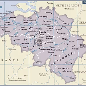
Glass Coaster : 1804 Cary Map Of Belgium And Luxembourg John Cary


![]()
Home Decor from Universal Images Group (UIG)
1804 Cary Map Of Belgium And Luxembourg John Cary
1804, Cary Map of Belgium and Luxembourg, John Cary, 1754 - 1835, English cartographer
Universal Images Group (UIG) manages distribution for many leading specialist agencies worldwide
Media ID 38550642
© Artokoloro Quint Lox Limited
1754 – 1835 1804 English Cartographer John Cary Antique Map Latitude Longitude Mappa Mundi Old Antique Plan Old Antique View Ols Antique Map Rare Old Maps Topo
Glass Coaster
Individual Glass Coaster. Stylish and elegant polished safety glass, toughened and heat resistant (10x10cm, 7mm thick). Price shown is per individual coaster.
Individual Glass Coaster. Elegant polished safety toughened glass and heat resistant, matching Place Mats are also available
Estimated Image Size (if not cropped) is 7.6cm x 6.9cm (3" x 2.7")
Estimated Product Size is 10cm x 10cm (3.9" x 3.9")
These are individually made so all sizes are approximate
Artwork printed orientated as per the preview above, with landscape (horizontal) orientation to match the source image.
FEATURES IN THESE COLLECTIONS
> Animals
> Fishes
> G
> Grouper
> Europe
> Belgium
> Related Images
> Europe
> France
> Canton
> Landes
> Europe
> Luxembourg
> Maps
> Europe
> Luxembourg
> Related Images
> Historic
> Space exploration
> Maps and Charts
> Early Maps
> Maps and Charts
> Luxembourg
EDITORS COMMENTS
Step back in time to the early 19th century with this stunning print of John Cary's 1804 map of Belgium and Luxembourg. The renowned English cartographer, known for his meticulous attention to detail, has brought forth a masterpiece that showcases the geographical boundaries and topographical features of these two neighboring regions.
This vintage map is a testament to Cary's skillful use of color and illustration, as he carefully depicts the rolling hills, rivers, and cities that make up the landscape. From the bustling port city of Antwerp to the picturesque countryside of Luxembourg, every aspect is meticulously rendered in exquisite detail.
As you gaze upon this ancient chart, imagine yourself embarking on a journey through history. This map would have been used by travelers and explorers seeking to navigate these territories during a time when maps were an essential tool for discovery. Today, it serves as a beautiful piece of art that celebrates our shared human quest for knowledge and understanding.
Printed on high-quality paper using traditional techniques, this reproduction captures every nuance and texture from the original artwork. Hang it proudly in your home or office as a conversation starter that sparks curiosity about the world around us.
MADE IN THE UK
Safe Shipping with 30 Day Money Back Guarantee
FREE PERSONALISATION*
We are proud to offer a range of customisation features including Personalised Captions, Color Filters and Picture Zoom Tools
SECURE PAYMENTS
We happily accept a wide range of payment options so you can pay for the things you need in the way that is most convenient for you
* Options may vary by product and licensing agreement. Zoomed Pictures can be adjusted in the Basket.