Glass Coaster > Animals > Birds > Passerines > Finches > Atlantic Canary
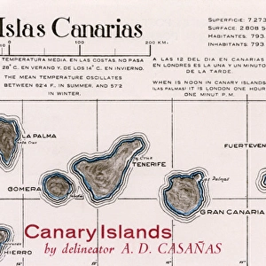
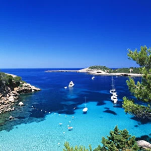
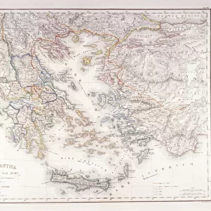
Glass Coaster : Map of Lanzarote, Canary Islands


![]()
Home Decor from Mary Evans Picture Library
Map of Lanzarote, Canary Islands
Map of Lanzarote, Canary Islands, with soundings in fathoms. Date: 1835
Mary Evans Picture Library makes available wonderful images created for people to enjoy over the centuries
Media ID 14262785
© Mary Evans / Pharcide
1830s 1835 Atlantic Canaries Canary Chart Charts Lanzarote Maps Navigation Soundings Fathoms
Glass Coaster
Individual Glass Coaster. Stylish and elegant polished safety glass, toughened and heat resistant (10x10cm, 7mm thick). Price shown is per individual coaster.
Individual Glass Coaster. Elegant polished safety toughened glass and heat resistant, matching Place Mats are also available
Estimated Image Size (if not cropped) is 5.7cm x 7.6cm (2.2" x 3")
Estimated Product Size is 10cm x 10cm (3.9" x 3.9")
These are individually made so all sizes are approximate
Artwork printed orientated as per the preview above, with portrait (vertical) orientation to match the source image.
FEATURES IN THESE COLLECTIONS
> Animals
> Birds
> Passerines
> Finches
> Atlantic Canary
> Animals
> Mammals
> Muridae
> Water Mouse
> Arts
> Artists
> O
> Oceanic Oceanic
> Europe
> France
> Canton
> Landes
> Maps and Charts
> Related Images
EDITORS COMMENTS
1. Title: "Navigating the Waters of Lanzarote: A 19th-Century Maritime Chart" This map print, dated 1835, showcases the intricate details of Lanzarote, the easternmost island in the Canary Islands archipelago located in the Atlantic Ocean. The chart, with soundings in fathoms, offers a glimpse into the maritime history of this volcanic island and its surrounding waters. During the 1830s, precise cartography was crucial for seafarers navigating the vast Atlantic Ocean. This map, with its meticulous depiction of the Lanzarote coastline, would have been an essential tool for sailors planning their voyages to and from the island. The soundings, measured in fathoms, indicate the depth of the seabed, helping navigators to avoid dangerous shoals and reefs. The map reveals the unique geography of Lanzarote, with its rugged cliffs, sandy beaches, and volcanic features. The island's position in the Atlantic Ocean is clearly marked, along with other notable landmarks such as the harbor of Arrecife, the capital city, and the nearby islets of Graciosa and Fuerteventura. This map print not only serves as a testament to the ingenuity and skill of 19th-century cartographers but also offers a fascinating glimpse into the maritime history of Lanzarote and the Canary Islands. It invites us to imagine the brave sailors who relied on such charts to traverse the Atlantic, braving the elements and the unknown to explore new lands and forge connections between distant shores. In conclusion, this 1835 map of Lanzarote, Canary Islands, with its soundings in fathoms, offers a captivating glimpse into the maritime history of this intriguing island and the era of sail. It is a reminder of the importance of precise cartography in the age of exploration and the enduring allure of the Atlantic Ocean.
MADE IN THE UK
Safe Shipping with 30 Day Money Back Guarantee
FREE PERSONALISATION*
We are proud to offer a range of customisation features including Personalised Captions, Color Filters and Picture Zoom Tools
SECURE PAYMENTS
We happily accept a wide range of payment options so you can pay for the things you need in the way that is most convenient for you
* Options may vary by product and licensing agreement. Zoomed Pictures can be adjusted in the Basket.