mail_outline sales@mediastorehouse.com
Framed Print
Antique Framed Print
Premium Framed Print
Canvas Print
Metal Print
Photographic Print
Poster Print
Fine Art Print
Mounted Print
Glass Frame
Acrylic Blox
Jigsaw Puzzle
Tote Bag
Photo Mug
Greetings Card
Postcard
Cushion
Mouse Mat
Glass Place Mat
Glass Coaster
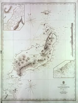
Map of Lanzarote, Canary Islands, with soundings in fathoms. Date: 1835
Engraving depicting divers searching for pearls5309078 Engraving depicting divers searching for pearls; (add.info.: Engraving depicting divers searching for pearls. The deepest a diver could venture without a suit was 12 fathoms (65.8m)
Engraving depicting pearl fishers, in British Ceylon, Sri Lanka, 19th century5309079 Engraving depicting pearl fishers, in British Ceylon, Sri Lanka, 19th century; (add.info.: Engraving depicting pearl fishers, in British Ceylon, Sri Lanka)
A "Six Bells"Drink, a Thirsty Officers Brilliant Idea and what came of it (engraving)1056693 A " Six Bells" Drink, a Thirsty Officers Brilliant Idea and what came of it (engraving) by Ralston, William (1848-1911) (after); Private Collection; (add.info)
LONG WORMA tapeworm taken from a patient in Paris by Dr Nicolas ?Antry on 9th June 1698 which measured 4 fathoms long before it broke off! Date: 1698
Map of Tenerife, Canary Islands, with soundings in fathoms. Date: 1838
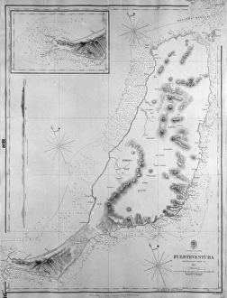
Map of Fuerteventura, Canary Islands, with soundings in fathoms. Date: 1835
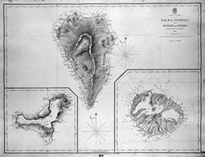
Map of Palma, Gomera and Hierro, Canary IslandsMap of Palma, Gomera and Hierro (or Ferro), Canary Islands, with soundings in fathoms. Date: 1837
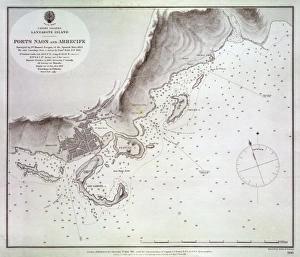
Map of Naos and Arrecife, Lanzarote, Canary IslandsMap of the ports of Naos and Arrecife, Lanzarote, Canary Islands, surveyed by the Spanish Navy in 1853, with outer soundings from a survey of 1835, updated in 1880. Date: 1881
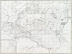
Basin of the North Atlantic Ocean, 1854 C016 / 8983Basin of the North Atlantic Ocean. 1854 edition of the first printed bathymetric map, showing seabed depths in the North Atlantic. The original data was gathered in the 1830s